
Excavations at Lucky Lane/Colleton Crescent, Exeter 1980 (Exeter archive site 74)
Exeter City Council, Cotswold Archaeology, 2015. https://doi.org/10.5284/1035211. How to cite using this DOI
Data copyright © Exeter City Council unless otherwise stated
This work is licensed under the ADS Terms of Use and Access.

Primary contact
Andrew
Pye
Principal Project Manager (Heritage)
Exeter City Council
Civic Centre
Paris Street
Exeter
EX1 1NN
England
Tel: 01392 265 224
Resource identifiers
- ADS Collection: 2040
- DOI:https://doi.org/10.5284/1035211
- How to cite using this DOI


Introduction
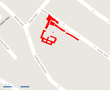
From February to May 1980, excavations took place in an area enclosed by Lucky Lane, Friars Gate and Colleton Crescent. This area was undergoing redevelopment of the grounds of the listed Magnolia House which was itself undergoing reconstruction. The excavations were conducted by the Exeter Museums Archaeological Field Unit.
The site was situated about 150 metres south of the South Gate of the City Wall at SX 9214/9213 and was outside the Roman legionary fortress; about 230 metres south-east of the south-east corner of the defences. The archaeological investigation comprised a series of machine-dug trenches cut on a north-west/south-east alignment, over a distance of 44 metres, on the south-eastern side of the site.
Remains of the post-medieval, medieval and Roman civil periods were recorded overlying features of the Roman military period which at Exeter dates from c AD 55/60 to c AD 75/80. Roman military levels were first encountered at about 22.6 metres above Ordnance Datum. Only a few features of Roman military date were in fact recorded; the bulk of the features on site related to the remains of buildings associated with the 13th-century Friary.
