
Excavations at Flowerpot Lane, Exeter 1986 (Exeter archive site 85)
Exeter City Council, Cotswold Archaeology, 2015. https://doi.org/10.5284/1035222. How to cite using this DOI
Data copyright © Exeter City Council unless otherwise stated
This work is licensed under the ADS Terms of Use and Access.

Primary contact
Andrew
Pye
Principal Project Manager (Heritage)
Exeter City Council
Civic Centre
Paris Street
Exeter
EX1 1NN
England
Tel: 01392 265 224
Resource identifiers
- ADS Collection: 2051
- DOI:https://doi.org/10.5284/1035222
- How to cite using this DOI


Introduction
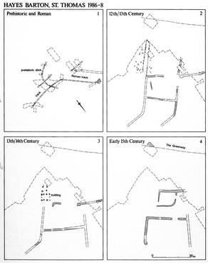
The site of medieval Hayes Barton in St. Thomas lies at Flowerpot Lane on the west bank of the Exe at the end of Okehampton Street, the site was investigated due to a proposal to build houses on the site. The excavation was completed at the end of February 1987.
The medieval estate known as the prebend of Hayes was created in the late 11th or early 12th century to support one of four prebendaries attached to St. Mary's Chapel in Exeter Castle. A house is documented on the site of Hayes Barton from the later 13th century. This would, perhaps, have been occupied by the bailiff of the prebend who is mentioned in deeds and presumably farmed the demesne lands.
The earliest features cutting into the colluvium date from the late 12th or early 13th century. A small rectangular ditched enclosure at the north-eastern limit of the excavation is likely to have contained a building in its northern corner which left no trace.
In the late 15th century, a large non-domestic building, believed to have been a barn, occupied the eastern corner of a yard bounded by cob walls.
In the early 16th century, the ground level over the whole site was raised up to 0.5 metres by means of an extensive spread of dumped alluvium. Some of this material must have been brought in from sources nearby but quite a lot of it was dug from ditches which now defined the settlement enclosure in the manner of a small-scale moat.
In the mid 16th century, the house was modernised by the addition of a new solar block at the west end of the hall. This included an external stair turret and no doubt contained a parlour and perhaps a dining room on the ground floor with sleeping chambers above.
William Peter is documented as inheriting the house and estate in 1571 and living there until his death in 1614, during which time he filled in the ditches and built cob boundary walls without stone footings in place of the hedges which were there previously. This description matches well the character of the later 16th century enclosure walls and outbuildings revealed by the excavation.
The excavation provided a picture of a considerable two-storey building with a double doorway in the north wall on the ground floor. The eastern part of the ground floor was clearly built as a chapel since it contains a piscina in the south wall and a holy water stoup is situated externally on the east side of the eastern doorway in the north wall.
