
Rapid Coastal Zone Assessment: North East
Archaeological Research Services Ltd, 2009. (updated 2011) https://doi.org/10.5284/1000385. How to cite using this DOI
Data copyright © English Heritage, Archaeological Research Services Ltd unless otherwise stated
This work is licensed under the ADS Terms of Use and Access.


Primary contact
Archaeological Research Services Ltd
Angel House
Portland Square
Bakewell
DE45 1HB
UK
Tel: 01629 814540
Resource identifiers
- ADS Collection: 884
- DOI:https://doi.org/10.5284/1000385
- How to cite using this DOI
Overview
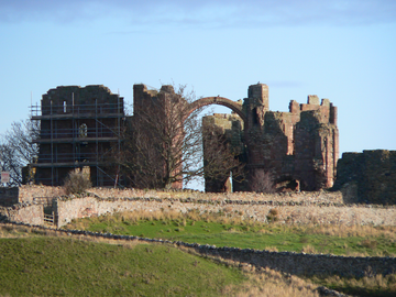
The North East Rapid Coastal Zone Assessment, or NERCZA, is one of a series of projects initiated by English Heritage around the coasts of England. The brief specifically required that the assessment be undertaken with reference to Defra's Shoreline Management Plans (SMPs). The Rapid Coastal Zone Assessment Surveys (RCZAS) are an English Heritage initiative to inform and develop our knowledge of the coastal historic environment. For more information on the RCZCAS please see the English Heritage RCZAS webpages.
The NERCZA study area consists of approximately 200km of coastline between the Lowest Astronomical Tide (LAT) and 1km inland from Mean High Water Springs (MHWS), and includes Coquet Island and the Farne Islands which lie offshore and Holy Island, joined to the mainland at low tide by a causeway. The review of the heritage assets has been based on a consideration of two data sets. The first consists of the Historic Environment Records (HERs) maintained by or for the Local Authorities with curatorial responsibilities for this section of the coast, namely North Yorkshire County Council, the North York Moors National Park Authority, Tees Archaeology (for Redcar and Cleveland, Middlesbrough, Stockton-on-Tees and Hartlepool), Durham County Council, Tyne and Wear Specialist Conservation Team (for South Tyneside and North Tyneside) and Northumberland County Council. The second data set consists of the aerial photograph coverage of the study area from which all archaeological features visible have been mapped to the standards of English Heritage's National Mapping Programme. Within the context of the NERCZA, this has been referred to as the Aerial Photograph Transcription Exercise (APTE).
The NERCZA Aerial Survey
The survey area consists of complete 1km squares which encompassing a strip of land from the lowest astronomical tide level (LAT) to a line 1km inland from Mean High Water Springs (MHWS), along the coast from Whitby in the south to the Anglo-Scottish border in the north. Digital maps at a nominal scale of 1:10,000 and supporting records were produced to National Mapping Programme (NMP) standards for an area of 560km² of which 402km² is inland of MHWS and the remainder falls within the inter-tidal zone between MHWS and LAT. In only mapping a narrow corridor along the coast this project deviates from the normal NMP practice of mapping whole 1:10,000 map quarter sheets. Mapping started on 1st March 2007 and was completed by 22nd July 2008 (AMIE Event No. 1453221).
The project mapped and recorded archaeological sites varying in date and type from prehistoric enclosures to twentieth century military remains. Records for 968 new sites, with a further 270 enhancements to existing records, were input to the National Monuments Record (NMR) database AMIE.
The aerial survey mapping component of the project was undertaken by ARS Ltd Investigators based with EH's Aerial Survey team in York.
Phase 2: Field Survey
The project aimed to rapidly survey all extant archaeological features visible at each of ten survey locations identified by Phase 1 of the project and survey and sample inter-tidal peat deposits at an additional four locations. The results of this survey and sampling can then be utilised to enhance the existing HER and NMR record and provide a useful tool to feed back to the Shoreline Management Plans and better inform the management of the archaeology of coastal margin in future. The results and outputs of the NERCZA project can also be used to help local communities better engage with their coastal heritage in future.
A digital photo archive of 2733 JPEG images was amassed during the project, as well as additional detailed imagery of eroding peat layers at Low Hauxley, Northumberland. Upon completion of the initial fieldwork more than 500 sites had been recorded, of which 115 were new records and the remainder provided significant enhancement to existing records. Along with this a further 100 Second World War sites have been identified within the Northumberland Coast Area of Outstanding Natural Beauty as part of a separate survey project which focussed only on the remains surviving from the Second World War. This project was undertaken on behalf of the Northumberland Coast AONB and undertaken after the completion of the NERCZA Phase 2 fieldwork. The same methodology was employed by Archaeological Research Services Ltd in the course of this survey during February 2010. This additional work provided an additional 20 new records. The data from this survey has been added to the project GIS along with the photographic and paper archive, increasing the scope of the NERCZA Phase 2 field survey. This gave a total of 609 records for the project with 135 of these being new records not previously incorporated into the regional HER data.
