
Extensive Urban Survey - Northamptonshire
Glenn Foard, Jenny Ballinger, J Taylor, 2006. https://doi.org/10.5284/1000257. How to cite using this DOI
Data copyright © Northamptonshire County Council, English Heritage unless otherwise stated
This work is licensed under the ADS Terms of Use and Access.

Primary contact
Charlotte
Walker
Resource identifiers
- ADS Collection: 451
- DOI:https://doi.org/10.5284/1000257
- How to cite using this DOI

Overview
Roman (Jeremy Taylor)
The data collection and analysis in this overview and the accompanying town reports were collated as part of the Northamptonshire Extensive Urban Survey but also draw upon the author's current work on the development of Roman urbanism in the wider East Midlands and the province of Britain. This was conducted in part as a follow up to research on Iron Age and Roman rural settlement in the region contained within a PhD thesis at the University of Durham, through collating the Northamptonshire data for the Roman Regional Resource Assessment and Research Agenda for the East Midlands currently in the course of publication and as part of ongoing research at the University of Leicester.
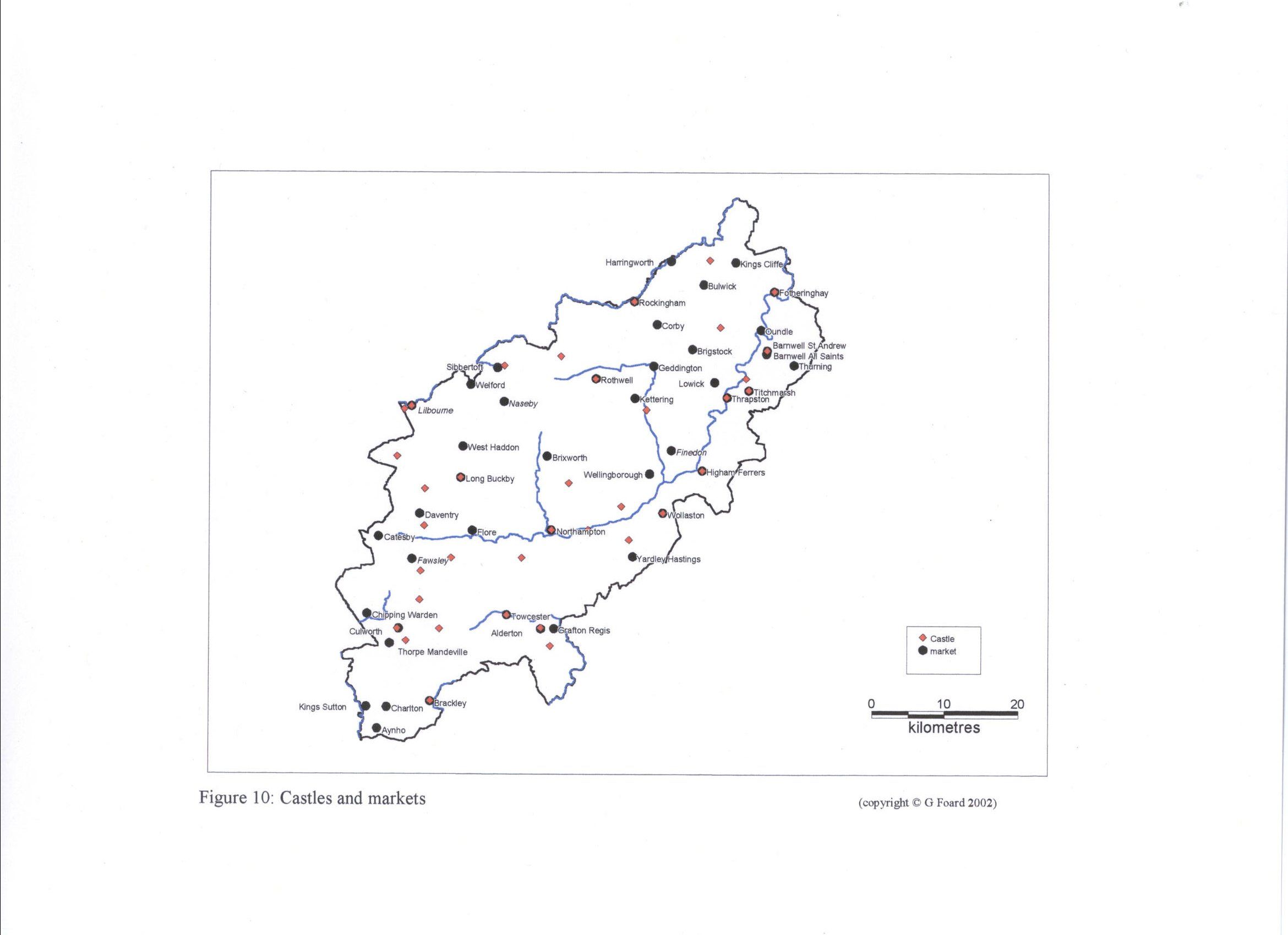
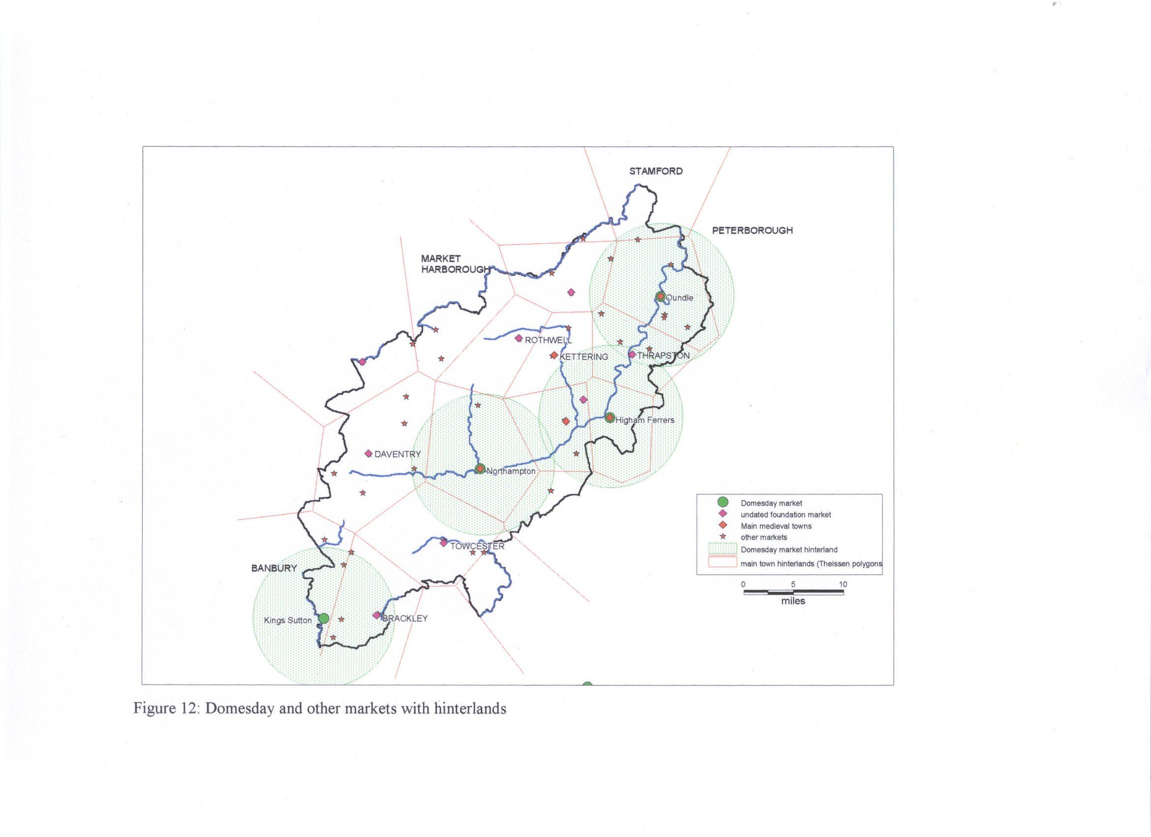
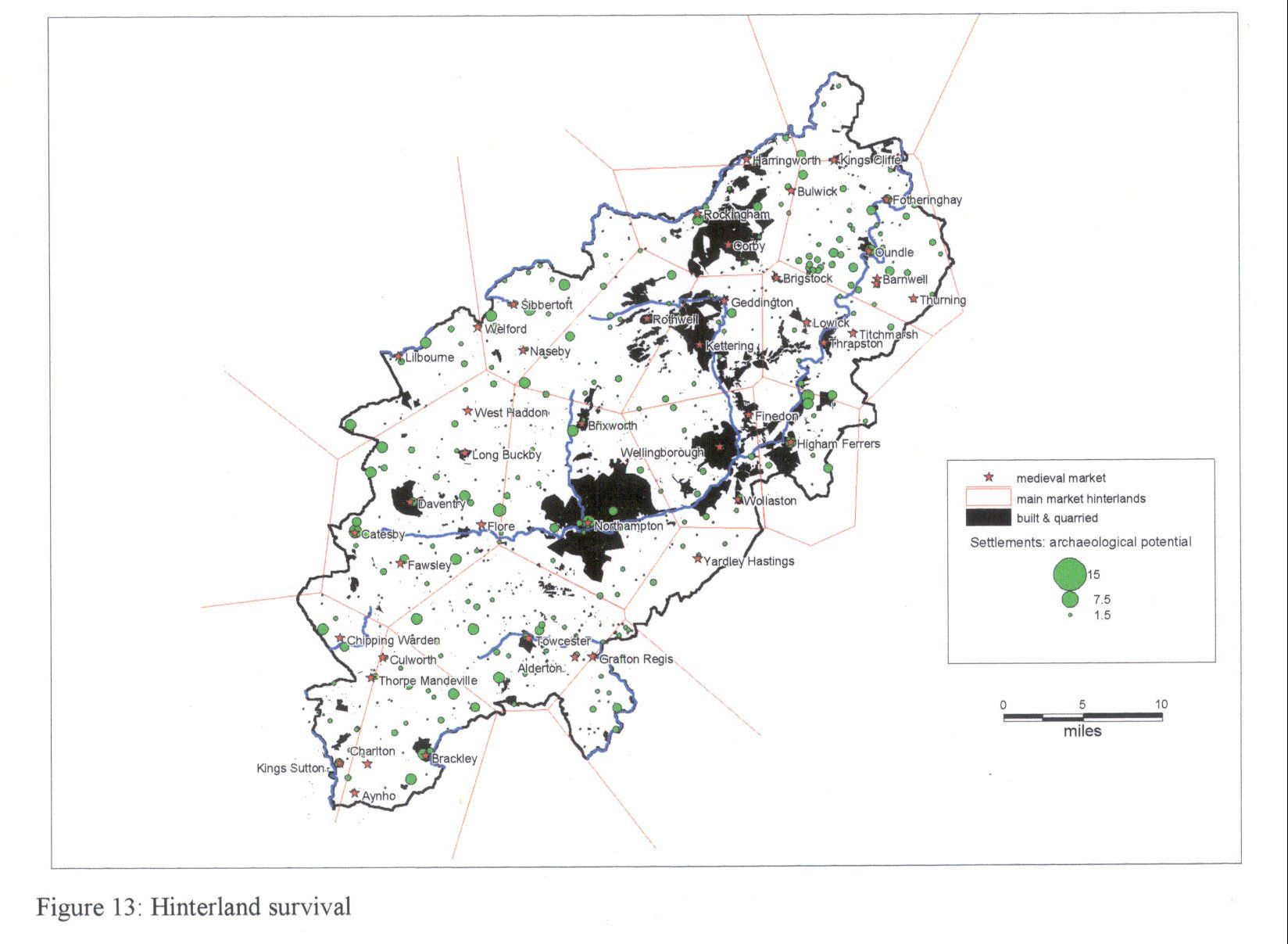
Medieval and Post Medieval (Glenn Foard)
In addition to the data collection and analysis carried out as part of the Extensive Urban Survey, the present chapter and the specific medieval and post medieval settlement reports draw heavily upon the results of systematic work on the archaeology and history of the small towns of Northamptonshire begun in the late 1970s by the author. This was conducted in part through Northamptonshire County Council, as part of the development of an overall strategy for the management of the archaeological resource, assisted by various temporary staff working on government funded 'job creation' schemes. The people involved in this work which contributed to a greater or lesser extent to the study of the small towns included Pauline Moore, Gillian Rickard, Steven Mitchell and Anne Foard. The majority of the data collection and analysis was however conducted a private research by the author.
The work in the late 1970s and early 1980s was never completed but resulted in the various fieldwork, most notably the excavations in Brackley in 1984 Castle Lane. In the mid 1990s funding became available through the English Heritage Extensive Urban Survey programme and this offered the opportunity to build upon the earlier work and provide a comprehensive reporting upon and strategy for the management of the small town archaeological resource of the county. The EUS Project Design, excluding the section on resources, is presented in Appendix 1. While the project was in progress a quite separate project on medieval urbanisation in the region was undertaken by Laughton and Jones based in Birmingham and Leicester University respectively. The results of this study were not available in time that work on the EUS was in progress although Laughton did contribute to the documentary study of Daventry and Towcester in the EUS. It is possible that further re-evaluation may be necessary for a number of settlements when the results of this study are fully published, but on the basis of the information seen for Towcester and Daventry it is not expected that this will require major changes in the overall base data or assessments presented in the EUS reports. The East Midlands Regional Research Framework papers were also completed too late to contribute directly to the EUS, although various of the issues discussed in the seminars which led up to the preparation of those papers have had an influence on the content of this overview.
Industrial Period (Jenny Ballinger)
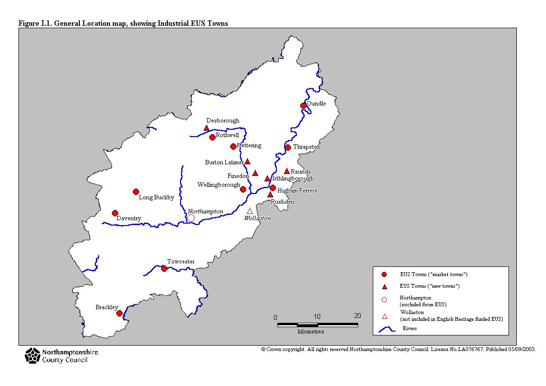
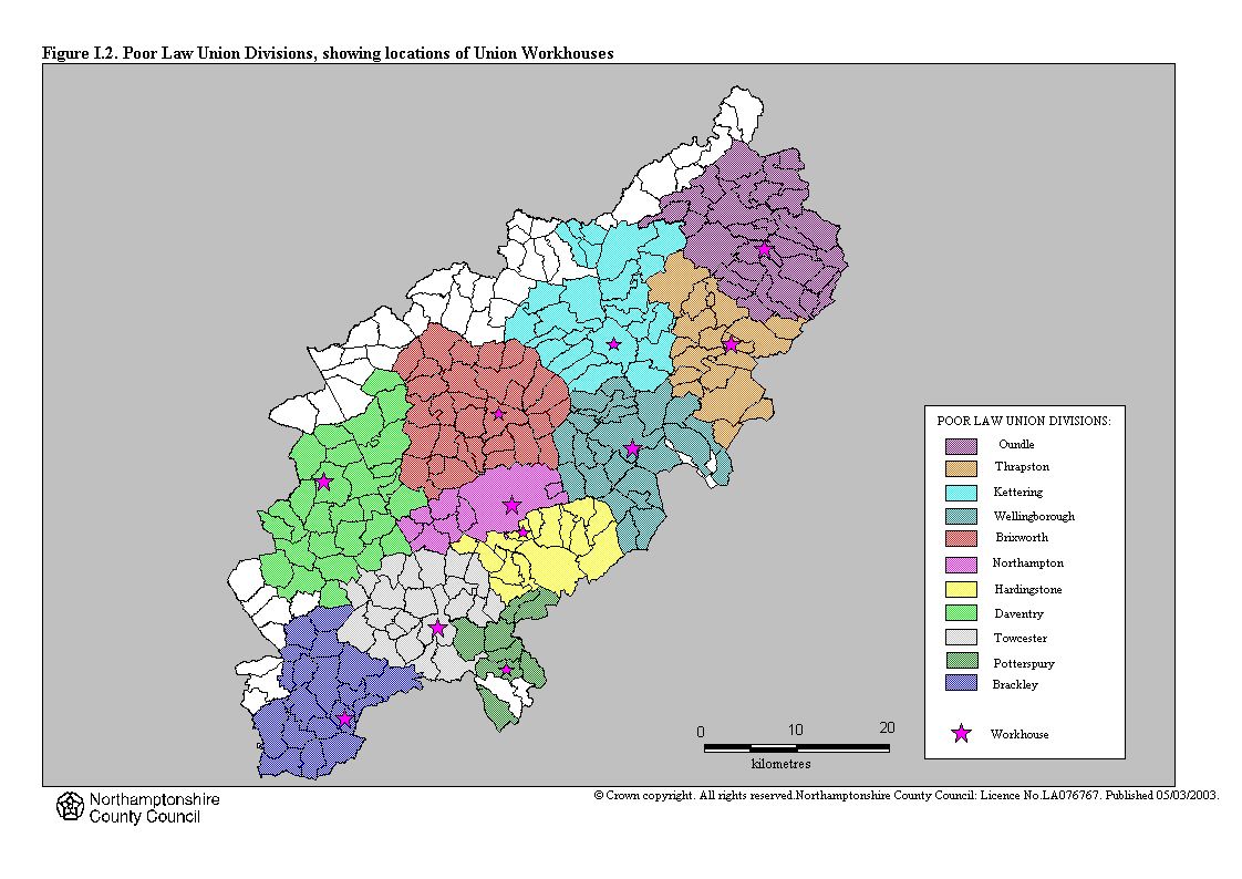
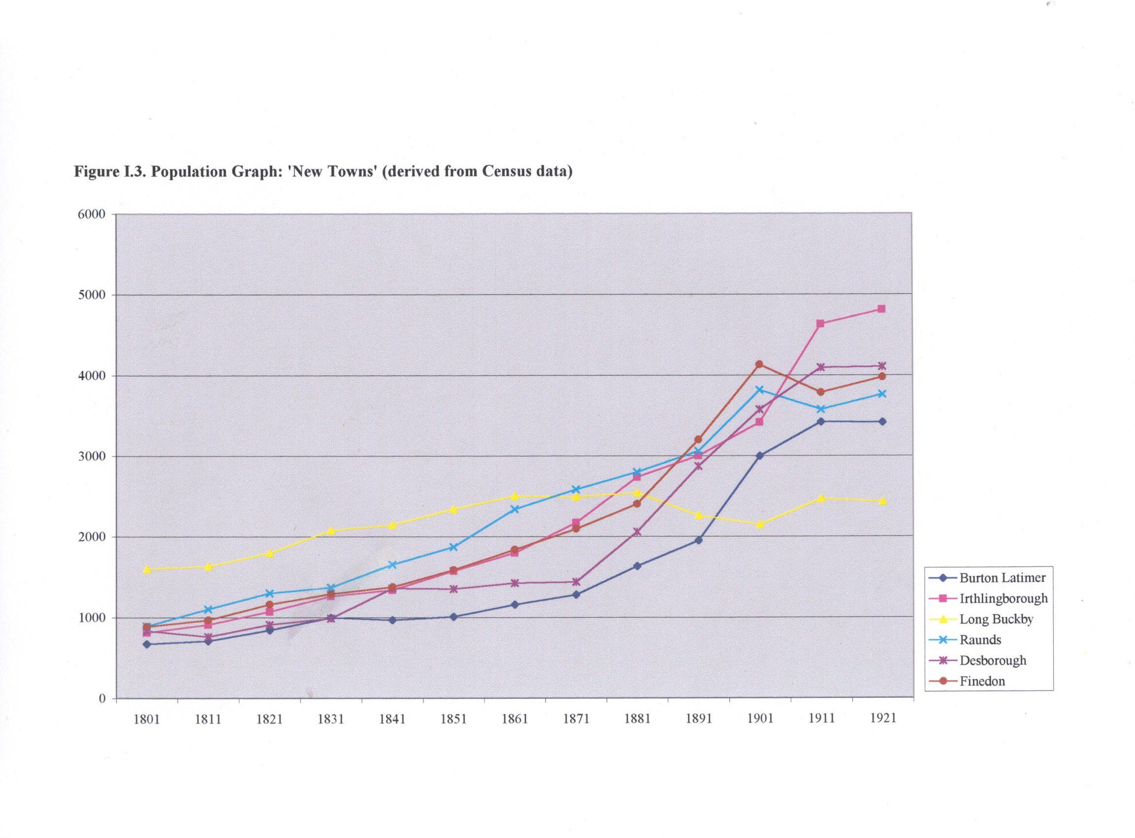
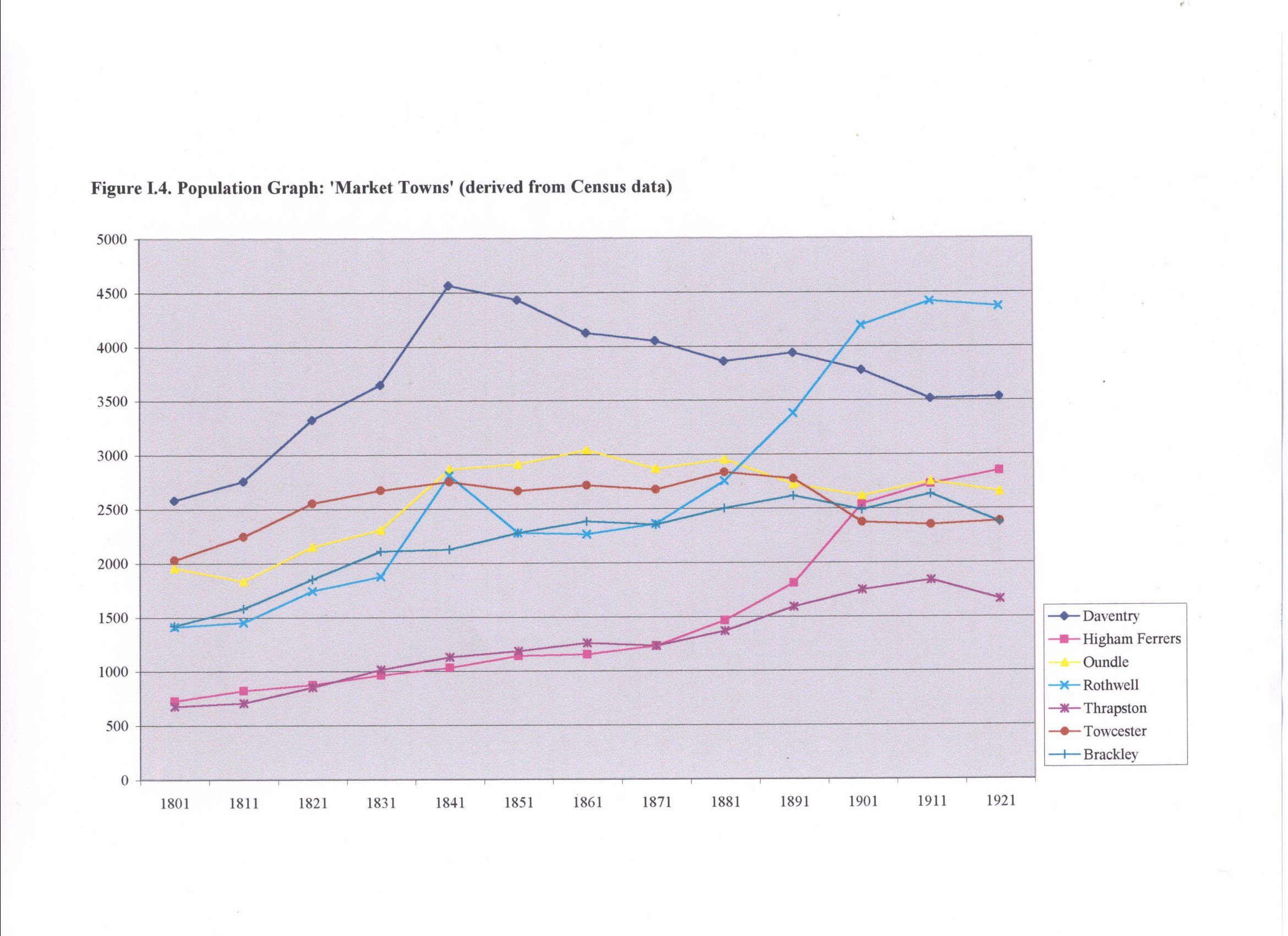
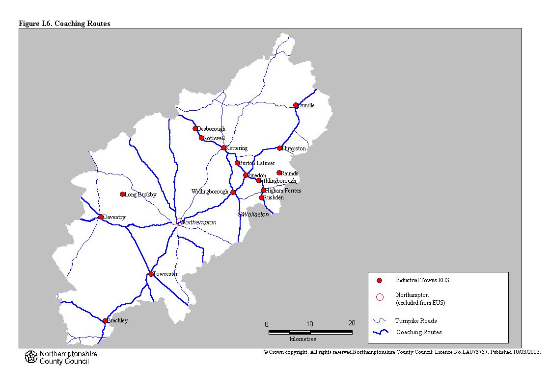
The 'industrial period' has been defined, for the purposes of this survey, as the period 1750-1939 inclusive. A total of 16 settlements in Northamptonshire were surveyed for this period. Ten of these settlements were towns in the medieval and post medieval period and their urban status continued through; the remaining six are "new" towns which underwent a process of industrialisation and urbanisation in the 19th-century and evolved from villages into larger urban settlements. The town of Corby has not been included in the survey as the main period of industrialisation for this town was after 1939. In addition to the 16 settlements which were surveyed as part of the Extensive Urban Survey, the town of Wollaston was surveyed by Kate Richards (following exactly the same methodology used for the Extensive Urban Survey) as part of her undergraduate degree at University College Northampton. The report for Wollaston was not completed in time to be considered for this overview, but the individual report is included with the remainder of the towns. The distinction between "industrialised village" and town in the period is difficult to determine and an arbitrary division has been made based on population statistics. The survey has included all settlements with a population of 2000 or more in 1901; although Thrapston, which had a population of only 1747, has also been included as professional judgement indicated that it had a clear role as an urban centre (Table I.1). Northampton has not been included in the Extensive Urban Survey, as the town had already been subject to an Intensive Urban Survey, also funded by English Heritage. The period following 1750 was not studied as part of this earlier survey and this has caused major problems in developing an understanding of industrialisation and urbanisation in Northamptonshire in the period following 1750. Similarly it has not been possible to find comparative data for the town of Peterborough, which until 1974 was within the administrative boundary of the county of Northamptonshire or to assess larger urban areas such as Leicester, Coventry and Birmingham.
Overview Text
The following PDF documents contain the full Overview Chapter and Appendices from the Northamptonshire Extensive Urban Survey project:
| Northamptonshire EUS Overview Chapter | 580Kb | |
| Northamptonshire EUS Appendices | 438Kb |
Overview Figures
The following JPG images refer to the Figures mentioned in the Overview Chapter PDF document (above):
Roman
