
Cowclose House, Barningham, County Durham. Building Recording (OASIS ID: northern1-329406)
Northern Archaeological Associates, 2019. https://doi.org/10.5284/1050902. How to cite using this DOI
Data copyright © Northern Archaeological Associates unless otherwise stated
This work is licensed under a Creative Commons Attribution 4.0 International License.

Primary contact
Northern Archaeological Associates
Marwood House
Harmire Enterprise Park
Barnard Castle
Co. Durham
DL12 8BN
Tel: 01833 690 800
Resource identifiers
- ADS Collection: 3384
- DOI:https://doi.org/10.5284/1050902
- How to cite using this DOI
Introduction
Northern Archaeological Associates Ltd (NAA) was commissioned by Edward Milbank to undertake a phase of archaeological historic building recording at Cowclose House, Barningham, Durham. This work was completed in advance of the conversion of the Grade II listed property for holiday accommodation and partially fulfils Condition 10 of the related planning consent (DM/17/00849/FPA).
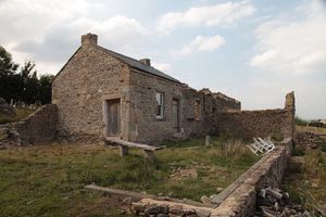
Cowclose House is located approximately 2km south-east of Barningham on an unnamed road that follows the northern edge of Barningham Moor. The farmstead lies on the western shore of an artificial lake that was created by the damming of Gordale Beck in the late 20th century. The building is a traditional Yorkshire longhouse, built of sandstone and limestone rubble, with a carved lintel on the main door bearing the date 1697. The documentary evidence seems to support a late 17th-century construction date and much of the surviving fabric can be attributed to this period, except for the projecting east byre, which was constructed in the mid-19th century.
By the late 1930s, the building was abandoned and remained in a semi-ruinous state until a recent phase of renovation made the southern bay watertight for use as a shelter for anglers. The proposed conversion plans will see the restoration of the whole building, ensuring a long-term sustainable future for this historic structure.
Cowclose House is considered to be of high heritage significance as a good example of a former longhouse that features preserved evidence of a byre, barn and domestic quarters under the same roof. The building is historically significant not only for its age but also its association with landownership changes over the centuries. In addition, it forms an important part of the historic landscape.
In accordance with Condition 10 of the granted planning consent, a Level 2 written, drawn and photographic survey of the Grade II listed building was undertaken, which is suitable to mitigate against any loss of heritage significance arising from the conversion. Although there remain a number of outstanding questions as to the phasing and development of the building, the following report and accompanying archive are considered to be sufficient to meet the building recording requirement. However, a phase of archaeological monitoring will be required during the removal or partial dismantling of any internal dividing walls, floor surfaces or blocked features.
