Rapid Coastal Zone Assessment Surveys (RCZAS)
Historic England, 2013. https://doi.org/10.5284/1106880. How to cite using this DOI
This work is licensed under a Creative Commons Attribution 4.0 International License.
Primary contact
Historic England
4th Floor, Cannon Bridge House
25 Dowgate Hill
London
EC4R 2YA
Tel: 020 7973 3700
Resource identifiers
- ADS Collection: 1587
- DOI:https://doi.org/10.5284/1106880
- How to cite using this DOI
Introduction to the Programme
England's coastal zone contains a legacy of historic assets including a complex array of fragile and irreplaceable archaeological remains, historic buildings and structures, and entire landscapes. These remains are vulnerable to a wide range of threats, including anthropogenic pressures, such those associated with commercial development and shoreline management, as well as natural processes of coastal change. It is now generally accepted that coastal physical processes are being forced by changes in annual rainfall distribution and wave direction, relative sea-level rise and an increase in storm incidence, all associated with wider climate change.
Over recent decades it has been recognised by coastal managers and Government that the entire English coastline cannot be maintained in its present form through the 21st century and that, where possible, natural processes should be allowed to operate. Coastal management is now viewed more holistically, taking into account not just the need to protect life and property but also environmental and social factors, as part of the move towards Integrated Coastal Zone Management.
Since the late 1990's English Hertiage have initiated a programme of Rapid Coastal Zone Assessment Surveys to enhance the knowledge of the coastal historic environment in an effort to inform future Shoreline Management Plans (SMPs). The information gained will feed into SMP consultation and development and will help to ensure effective mitigation of the effects of coastal change through the 21st century. It will also provide a data-base which may be used for further research and in the development control process
Completed Surveys (2009):
- North East England
- Yorkshire and Lincolnshire
- Dorset
- Cornwall South Coast
- The Inner Humber
- Norfolk
- Suffolk
- Essex
- North Kent
- Isles of Scilly
- Severn Estuary
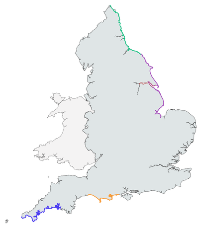
The map to the right highlights completed surveys with reports and data now available via the ADS; click on any of the coloured areas to access the relevant survey. For more information regarding other projects and for up-to-date information on RCZAS work please visit the Historic England RCZAS web pages.


