
Land south-west of Ripple, Worcestershire
Worcestershire Historic Environment and Archaeology Service, 2007. (updated 2008) https://doi.org/10.5284/1000261. How to cite using this DOI
Data copyright © Worcestershire Historic Environment and Archaeology Service unless otherwise stated
This work is licensed under the ADS Terms of Use and Access.


Primary contact
Robin
Jackson
Project manager
Worcestershire Historic Environment and Archaeology Service
Woodbury
Worcester University
Henwick Grove, Worcester
WR2 6AJ
England
Tel: 01905 855401
Resource identifiers
- ADS Collection: 785
- ALSF Project Number: 3369
- DOI:https://doi.org/10.5284/1000261
- How to cite using this DOI

Introduction
A staged archaeological assessment was undertaken by Worcestershire Historic Environment and Archaeology Service at Ripple Quarry, Worcestershire where RMC Aggregates (Western) Limited (now Cemex UK) have an outstanding, pre-PPG 16 planning permission for quarrying of c 52ha of land on the eastern side of the River Severn.
A desk-based appraisal and aerial photographic assessment (Stage 1) was followed by geophysical, metal-detector and earthwork surveys allied to examination of LiDAR mapping (Stage 2). Stage 3 comprised targeted evaluation trenching and geoarchaeological assessment of areas of potential identified during Stages 1 and 2.
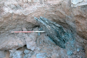
Although ground conditions on the floodplain during Stage 3 placed considerable constraints on the project, important results were obtained. Firstly, a Late Neolithic to Early Bronze Age post-pit was found alongside four less certainly archaeological features. These features appear to extend a boundary represented by a pit-alignment running across the adjacent terrace but masked by alluvium on the floodplain. The early date of the post-pit (established by radiocarbon dating of the surviving tree-trunk placed within it) raises important questions about floodplain utilisation at this period and the character of the activity represented. Secondly, the expected continuation of a trackway across the floodplain was confirmed by the discovery of two parallel ditches and associated banks. This trackway probably linked the Iron Age hillfort at Towbury to the River Severn.
Associated pollen, geoarchaeological and stratigraphic analysis combined to provide an impression of a degree of Late Neolithic/Early Bronze Age clearance on the floodplain, and a subsequent long period of slow aggradation, the rate of alluviation appearing to increase from the Iron Age onwards.
The Late Neolithic/Early Bronze Age post-pit and the probable Iron Age ditches are considered regionally significant and the post-pit of probable national significance. Associated alluvial deposits and pollen remains are also regionally significant and have a high potential to contribute to an understanding of long-term floodplain development and utilisation. This significance is enhanced in the light of the importance of the River Severn and of the very limited research previously undertaken on its floodplain.
Unfortunately definition of the potential extent of the activity represented and difficulties of interpreting the post-pit have hindered securing of further funding for this site at which quarrying has now commenced.
