
Silbury Hill
English Heritage, 2014. https://doi.org/10.5284/1024570. How to cite using this DOI
Data copyright © English Heritage unless otherwise stated
This work is licensed under the ADS Terms of Use and Access.

Primary contact
English Heritage
Fort Cumberland
Fort Cumberland Road
Eastney
Portsmouth
P04 9LD
UK
Tel: 01793 414700
Fax: 01793 414707
Resource identifiers
- ADS Collection: 1648
- DOI:https://doi.org/10.5284/1024570
- How to cite using this DOI
Introduction
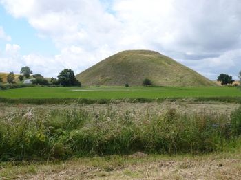
Silbury Hill from the eastern bank of the Winterbourne
English Heritage has been engaged in work at Silbury since May 2000 when a vertical shaft originally dug in 1776 re-opened up on the summit. After temporary stabilisation, a major investigative programme revealed further local problems associated with lateral tunnels dug at the base of the hill in 1849 and 1968. After much public debate and scrutiny, a scheme for permanent remedial works was agreed and work was duly carried out between 2007 and 2008.
The 2007/8 recording work identified numerous phases of the mound, suggesting that the archaeological stratigraphic sequence is considerably more complex than previously thought; the mound growing through many small events, rather than a few grand statements. The digital archive reflects the work that took place from the shaft opening on the summit of the hill in 2000 to the 2007/8 excavations and the assessment and analysis stages that followed.
