Thornborough Henges: Air Photo Mapping Project
Archaeological Services WYAS, 2006. https://doi.org/10.5284/1000279. How to cite using this DOI
Data copyright © Archaeological Services WYAS unless otherwise stated
This work is licensed under the ADS Terms of Use and Access.
Primary contact
Archaeological Services WYAS
Nepshaw Lane South
Morley
Leeds
LS27 7JQ
UK
Tel: 0113 535 0163
Resource identifiers
- ADS Collection: 494
- ALSF Project Number: 3897
- DOI:https://doi.org/10.5284/1000279
- How to cite using this DOI
Introduction
The Thornborough Henges Air Photo Mapping Project was funded by the Aggregates Levy Sustainability Fund (ALSF), as disbursed through English Heritage, and operated by Archaeological Services WYAS.
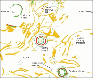
An area of 100 square kilometres, centred on the nationally important prehistoric henge complex at Thornborough North Yorkshire was surveyed to NMP standards from existing air photographs. Digital maps, at a nominal scale of 1:10,000, and supporting records were created by a small team of aerial investigators. This team was contracted by Archaeological sesrvices WYAS and based with English Heritage's Aerial Survey and Investigation at Tanner Row, York.
The project identified and mapped sites varying in date and type ranging from a Neolithic cursus to military reamains from the twentieth century. New AMIE records were created for 153 monuments or monument groups and a further 41 amendments were made to existing records.
The work also contributes to English Heritage's ongoing National Mapping Programme (NMP), generating a comprehensive record of the archaeology that is visible on air photographs for the whole of England. In addition to this the Thornborough Henges Air Photo Mapping Project is intrinsically linked to two other ALSF projects focusing on the Thornborough area:
- ALSF 3845: Thornborough Moor and Landscape - Conservation Plan
- ALSF 3314: Thornborough, North Yorkshire: Neolithic and Bronze-Age monument complex


