HMJ Underhill Archive
Deborah Harlan, Megan Price, 2004.
(updated 2013)
https://doi.org/10.5284/1000234. How to cite using this DOI
Digital Object Identifiers
Digital Object Identifiers (DOIs) are persistent identifiers which can be used to consistently and accurately reference digital objects and/or content. The DOIs provide a way for the ADS resources to be cited in a similar fashion to traditional scholarly materials. More information on DOIs at the ADS can be found on our help page.
Citing this DOI
The updated Crossref DOI Display guidelines recommend that DOIs should be displayed in the following format:
https://doi.org/10.5284/1000234
Sample Citation for this DOI
Deborah Harlan, Megan Price (2013) HMJ Underhill Archive [data-set]. York: Archaeology Data Service [distributor] https://doi.org/10.5284/1000234
Data copyright © University of Oxford unless otherwise stated
This work is licensed under the ADS Terms of Use and Access.
Primary contact
Prof
Helena
Hamerow
Institute of Archaeology
University of Oxford
36 Beaumont St
Oxford
OX1 2PG
England
Tel: 01865 278240
Fax: 01865 278254
Resource identifiers
- ADS Collection: 395
- DOI:https://doi.org/10.5284/1000234
- How to cite using this DOI
Digital Object Identifiers
Digital Object Identifiers (DOIs) are persistent identifiers which can be used to consistently and accurately reference digital objects and/or content. The DOIs provide a way for the ADS resources to be cited in a similar fashion to traditional scholarly materials. More information on DOIs at the ADS can be found on our help page.
Citing this DOI
The updated Crossref DOI Display guidelines recommend that DOIs should be displayed in the following format:
https://doi.org/10.5284/1000234
Sample Citation for this DOI
Deborah Harlan, Megan Price (2013) HMJ Underhill Archive [data-set]. York: Archaeology Data Service [distributor] https://doi.org/10.5284/1000234
Downloads
Albums
The HMJ Underhill collection comprises a series of digised lantern slides which have been organised into discrete thematic albums.
Stone Circles | Roman | Windmills | Photos
This album includes 47 images:
underhill26
underhill26.png
[DOWNLOAD] (Full Resolution) right-click and save link |
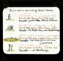
underhill26 Label : Terms used to describe megaliths. Great Stone Circles. Number 722 in Catalogue. On image: Menhir, Dolmen, Crom Lech, Trilithon Image created : Dec. 5, 1895 Period : Location : , , |
PNG
underhill26
underhill26.png
[DOWNLOAD] (Full Resolution) right-click and save link |
4.50 Mb |
XYb144
XYb144.png
[DOWNLOAD] (Full Resolution) right-click and save link |
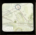
XYb144 Label : Map of Avebury & district showing circle and avenue. Number 747 in Catalogue. Image created : 1895 Period : Neolithic Location : Avebury, Wiltshire, Britain |
PNG
XYb144
XYb144.png
[DOWNLOAD] (Full Resolution) right-click and save link |
5.83 Mb |
XYb141
XYb141.png
[DOWNLOAD] (Full Resolution) right-click and save link |
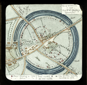
XYb141 Label : Plan of Avebury in 1722. [X added in 1895 to stones still extant]. Number 744 in Catalogue. Image created : 1895 Period : Neolithic Location : Avebury, Wiltshire, Britain |
PNG
XYb141
XYb141.png
[DOWNLOAD] (Full Resolution) right-click and save link |
7.15 Mb |

underhill21
underhill21.png
[DOWNLOAD] (Full Resolution) right-click and save link |
underhill21 Label : From S.E. to Dyke. Paint flaking damage. Number 752 in Catalogue. On image: H.M.J.U. Aug. 23, 95 Image created : Aug. 27 to Sept. 1, 1895 Period : Neolithic Location : Avebury, Wiltshire, Britain |
PNG
underhill21
underhill21.png
[DOWNLOAD] (Full Resolution) right-click and save link |
5.06 Mb |
underhill08
underhill08.png
[DOWNLOAD] (Full Resolution) right-click and save link |
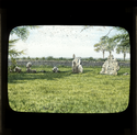
underhill08 Label : View towards the King Stone. Rollright, the Sunrise Stone, over the N.E. stone from the middle of the Ring. 741 in Catalogue. On Image: H.M.J.U. Sept. 3, 1895 Image created : Nov. 22 to 25, 1895 Period : Location : Rollright Stones, Oxfordshire, Britain |
PNG
underhill08
underhill08.png
[DOWNLOAD] (Full Resolution) right-click and save link |
4.69 Mb |

underhill20
underhill20.png
[DOWNLOAD] (Full Resolution) right-click and save link |
underhill20 Label : Stone of Outer Ring. South side, by the Marlborough Road. Number 758 in catalogue. On image: H.M.J.U. Aug. 22, 1895 Image created : Nov. 20 to 21, 1895 Period : Neolithic Location : Avebury, Wiltshire, Britain |
PNG
underhill20
underhill20.png
[DOWNLOAD] (Full Resolution) right-click and save link |
5.81 Mb |

underhill18
underhill18.png
[DOWNLOAD] (Full Resolution) right-click and save link |
underhill18 Label : Stone of Outer Ring, North side. By the Swindon Road. Number 756 in Catalogue. On image: H.M.J.U. Sept. 16, 1895 Image created : Nov. 13 and 14, 1895 Period : Neolithic Location : Avebury, Wiltshire, Britain |
PNG
underhill18
underhill18.png
[DOWNLOAD] (Full Resolution) right-click and save link |
4.05 Mb |

underhill03
underhill03.png
[DOWNLOAD] (Full Resolution) right-click and save link |
underhill03 Label : The Cove. Number 754 in Catalogue. On Image: H.M.J.U. Aug. 22, 1895 Image created : Oct. 28 to 31, 1895 Period : Neolithic Location : Avebury, Wiltshire, Britain |
PNG
underhill03
underhill03.png
[DOWNLOAD] (Full Resolution) right-click and save link |
5.11 Mb |
underhill16
underhill16.png
[DOWNLOAD] (Full Resolution) right-click and save link |
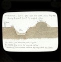
underhill16 Label : Section of Dyke and Ditch (1894). On image: (top) AVEBURY - Section of the Dyke and Ditch, made July 1894, showing its present form and the original outline. (bottom) The Green Line shows the original outline. 'Weathering' has rounded corners, and partly filled the Ditch. Number 750 in Catalogue. Image created : Dec. 6, 1895 Period : Neolithic Location : Avebury, Wiltshire, Britain |
PNG
underhill16
underhill16.png
[DOWNLOAD] (Full Resolution) right-click and save link |
4.12 Mb |

underhill14
underhill14.png
[DOWNLOAD] (Full Resolution) right-click and save link |
underhill14 Label : Dyke and Ditch, East side from same spot as view of South Stone. Number 749 in Catalogue. On image: H.M.J.U. 1895 Image created : Nov. 15 to 18 , 1895 Period : Neolithic Location : Avebury, Wiltshire, Britain |
PNG
underhill14
underhill14.png
[DOWNLOAD] (Full Resolution) right-click and save link |
4.85 Mb |

underhill13
underhill13.png
[DOWNLOAD] (Full Resolution) right-click and save link |
underhill13 Label : Beckhampton Avenue. The Devil's Quoits (Tip of Serpent's tail). Number 759 in Catalogue.On Image: H.M.J.U. Sept. 16, 1895 Image created : Nov. 18 & 19, 1895 Period : Neolithic Location : Avebury, Wiltshire, Britain |
PNG
underhill13
underhill13.png
[DOWNLOAD] (Full Resolution) right-click and save link |
4.82 Mb |

underhill09
underhill09.png
[DOWNLOAD] (Full Resolution) right-click and save link |
underhill09 Label : 2,000 years ago (Restoration) of Kennet Avenue. Paint flaking damage. Number 761 in Catalogue. On Image: H.M.J.U. Image created : Sept. 2 to 7, 1895 Period : Neolithic Location : Avebury, Wiltshire, Britain |
PNG
underhill09
underhill09.png
[DOWNLOAD] (Full Resolution) right-click and save link |
4.83 Mb |

underhill29
underhill29.png
[DOWNLOAD] (Full Resolution) right-click and save link |
underhill29 Label : Remains of the Kennet Avenue. Number 760 in Catalogue. On image: H.M.J.U. Aug. 22, 1895 Image created : Dec. 3 to 5, 1895 Period : Neolithic Location : Avebury, Wiltshire, Britain |
PNG
underhill29
underhill29.png
[DOWNLOAD] (Full Resolution) right-click and save link |
4.81 Mb |

underhill04
underhill04.png
[DOWNLOAD] (Full Resolution) right-click and save link |
underhill04 Label : Silbury Hill. Near the Bath Road, Avebury. Number 762 in Catalogue.On image: H.M.J.U. Sept. 16/95 Image created : Oct. 20 to 27, 1895 Period : Location : Avebury, Wiltshire, Britain |
PNG
underhill04
underhill04.png
[DOWNLOAD] (Full Resolution) right-click and save link |
4.50 Mb |
underhill02
underhill02.png
[DOWNLOAD] (Full Resolution) right-click and save link |
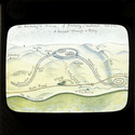
underhill02 Label : The Wansdyke is really five miles away. On image: Dr Stukeley's Vision of Avebury - restored 1723 A.D. - Serpent through a Ring. Number 745 in Catalogue. Image created : Nov. 25 to 27, 1895 Period : Neolithic Location : Avebury, Wiltshire, Britain |
PNG
underhill02
underhill02.png
[DOWNLOAD] (Full Resolution) right-click and save link |
4.19 Mb |

underhill12
underhill12.png
[DOWNLOAD] (Full Resolution) right-click and save link |
underhill12 Label : Stukeley's Tom Robinson. Avebury. From a tailpiece to one of Dr Stukeley's chapters. On image: The Good Dr William Stukeley's revenge on the Wicked Tom Robinson, 'Temple-destroyer'. Number 746 in Catalogue. Image created : 1895 Period : Location : , , |
PNG
underhill12
underhill12.png
[DOWNLOAD] (Full Resolution) right-click and save link |
4.84 Mb |
XYb174
XYb174.png
[DOWNLOAD] (Full Resolution) right-click and save link |
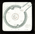
XYb174 Label : Plan of restored Stonehenge [in context]. 767 in Catalogue. Image created : 1895 Period : Neolithic Location : Stonehenge, Wiltshire, Britain |
PNG
XYb174
XYb174.png
[DOWNLOAD] (Full Resolution) right-click and save link |
5.07 Mb |

underhill10
underhill10.png
[DOWNLOAD] (Full Resolution) right-click and save link |
underhill10 Label : The larger Trilithon from South. 776 in Catalogue. On image: H.M.J.U. Image created : May 2 to 8, 1895 Period : Neolithic Location : Stonehenge, Wiltshire, Britain |
PNG
underhill10
underhill10.png
[DOWNLOAD] (Full Resolution) right-click and save link |
5.79 Mb |

underhill30
underhill30.png
[DOWNLOAD] (Full Resolution) right-click and save link |
underhill30 Label : From the nearest tumulus on E. 772 in Catalogue. On image: Afternoon April 17, 1895 Image created : April 27 to May 1, 1895 Period : Neolithic Location : Stonehenge, Wiltshire, Britain |
PNG
underhill30
underhill30.png
[DOWNLOAD] (Full Resolution) right-click and save link |
4.66 Mb |
XYb172
XYb172.png
[DOWNLOAD] (Full Resolution) right-click and save link |
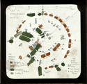
XYb172 Label : Plan of Stonehenge: the blue stones in position. 766 in Catalogue. Image created : 1895 Period : Neolithic Location : Stonehenge, Wiltshire, Britain |
PNG
XYb172
XYb172.png
[DOWNLOAD] (Full Resolution) right-click and save link |
6.60 Mb |

underhill37
underhill37.png
[DOWNLOAD] (Full Resolution) right-click and save link |
underhill37 Label : The Sunrise Stone of the Ring. Friar's Heel and Circle from NNE. 779 in Catalogue. On image: H.M.J.U. Aug. 20, 1895 Image created : Oct. 4 to 8, 1895 Period : Neolithic Location : Stonehenge, Wiltshire, Britain |
PNG
underhill37
underhill37.png
[DOWNLOAD] (Full Resolution) right-click and save link |
5.11 Mb |
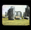
underhill27
underhill27.png
[DOWNLOAD] (Full Resolution) right-click and save link |
underhill27 Label : View to Friar's Heel across circle. Drawn from a photograph. On image Aug. 20, 1895 H.M.J.U. 781 in Catalogue. Image created : Dec. 12 to 16, 1895 Period : Neolithic Location : Stonehenge, Wiltshire, Britain |
PNG
underhill27
underhill27.png
[DOWNLOAD] (Full Resolution) right-click and save link |
5.07 Mb |

underhill38
underhill38.png
[DOWNLOAD] (Full Resolution) right-click and save link |
underhill38 Label : The Middle Trilithon and Altar. 778 in Catalogue. On image: H.M.J.U. Aug. 21, 1895 Image created : Oct. 8 to 10, 1895 Period : Neolithic Location : Stonehenge, Wiltshire, Britain |
PNG
underhill38
underhill38.png
[DOWNLOAD] (Full Resolution) right-click and save link |
4.70 Mb |
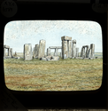
underhill36
underhill36.png
[DOWNLOAD] (Full Resolution) right-click and save link |
underhill36 Label : From the Earth Ring. View from the Vallum looking N.E. 775 in Catalogue. On image: Midday. March 27, 1895 Image created : May 4 to 6, 1895 Period : Neolithic Location : Stonehenge, Wiltshire, Britain |
PNG
underhill36
underhill36.png
[DOWNLOAD] (Full Resolution) right-click and save link |
4.98 Mb |

underhill35
underhill35.png
[DOWNLOAD] (Full Resolution) right-click and save link |
underhill35 Label : From the Earth Ring, looking E. Morning. View fom Vallum looking E. 773 in Catalogue. On image: Morning. Aug. 21, 1895 Image created : Sept. 22 to 29, 1895 Period : Neolithic Location : Stonehenge, Wiltshire, Britain |
PNG
underhill35
underhill35.png
[DOWNLOAD] (Full Resolution) right-click and save link |
5.18 Mb |
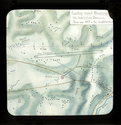
underhill23
underhill23.png
[DOWNLOAD] (Full Resolution) right-click and save link |
underhill23 Label : Map of surrounding country. 765 in Catalogue. On image: Country round Stonehenge. The Dots are barrows. There are 465 in the neighbourhood. Image created : 1895 Period : Location : Stonehenge, Wiltshire, Britain |
PNG
underhill23
underhill23.png
[DOWNLOAD] (Full Resolution) right-click and save link |
5.03 Mb |
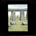
underhill34
underhill34.png
[DOWNLOAD] (Full Resolution) right-click and save link |
underhill34 Label : View of Stone over which the sun rises on midsummer morning. View to Friar's Heel from the interior. 780 in Catalogue. On image: Morning April 13, 1895. From the 'Altar' looking E.N.E. [Note on back: E.N.E. is a mistake. The direction is really barely one point E of N.E.] Image created : April 27 to 28, 1895 Period : Neolithic Location : Stonehenge, Wiltshire, Britain |
PNG
underhill34
underhill34.png
[DOWNLOAD] (Full Resolution) right-click and save link |
3.45 Mb |

underhill33
underhill33.png
[DOWNLOAD] (Full Resolution) right-click and save link |
underhill33 Label : From my old sketch. Looking S.E. View from W. 774 in Catalogue. On image: H.M.J.U. Aug. 23, 1870 Image created : July 22 to 24, 1894 Period : Neolithic Location : Stonehenge, Wiltshire, Britain |
PNG
underhill33
underhill33.png
[DOWNLOAD] (Full Resolution) right-click and save link |
4.78 Mb |

underhill32
underhill32.png
[DOWNLOAD] (Full Resolution) right-click and save link |
underhill32 Label : From the Road to Amesbury: afternoon. Distant view from road. 771 in Catalogue. On image: H.M.J.U. Aug. 19, 1895 Image created : Sept. 30 to Dec. 4, 1895 Period : Neolithic Location : Stonehenge, Wiltshire, Britain |
PNG
underhill32
underhill32.png
[DOWNLOAD] (Full Resolution) right-click and save link |
5.03 Mb |
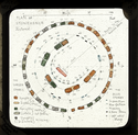
XYb173
XYb173.png
[DOWNLOAD] (Full Resolution) right-click and save link |
XYb173 Label : Plan of restored Stonehenge. 768 in Catalogue. Image created : 1895 Period : Neolithic Location : Stonehenge, Wiltshire, Britain |
PNG
XYb173
XYb173.png
[DOWNLOAD] (Full Resolution) right-click and save link |
6.16 Mb |

underhill15
underhill15.png
[DOWNLOAD] (Full Resolution) right-click and save link |
underhill15 Label : Restored. Bird's eye view. 769 in Catalogue. Image created : May 17 to 25, 1895 Period : Neolithic Location : Stonehenge, Wiltshire, Britain |
PNG
underhill15
underhill15.png
[DOWNLOAD] (Full Resolution) right-click and save link |
5.75 Mb |

underhill40
underhill40.png
[DOWNLOAD] (Full Resolution) right-click and save link |
underhill40 Label : Restoration: side view. From E. Barclay's outline. 770 in Catalogue. On image: H.M.J.U. Image created : Nov. 8 to 12, 1895 Period : Neolithic Location : Stonehenge, Wiltshire, Britain |
PNG
underhill40
underhill40.png
[DOWNLOAD] (Full Resolution) right-click and save link |
4.74 Mb |

underhill39
underhill39.png
[DOWNLOAD] (Full Resolution) right-click and save link |
underhill39 Label : Restoration: 2000 BC. Sunrise on Midsummer morning, looking along the axis. 782 in Catalogue. On image: H.M.J.U. Image created : Nov. 30 to Dec. 2, 1895 Period : Neolithic Location : Stonehenge, Wiltshire, Britain |
PNG
underhill39
underhill39.png
[DOWNLOAD] (Full Resolution) right-click and save link |
4.04 Mb |

XYb130
XYb130.png
[DOWNLOAD] (Full Resolution) right-click and save link |
XYb130 Label : Plan of Rollright Stones. 736 in Catalogue. Image created : 1895 Period : Location : Rollright Stones, Oxfordshire, Britain |
PNG
XYb130
XYb130.png
[DOWNLOAD] (Full Resolution) right-click and save link |
5.79 Mb |
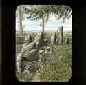
underhill07
underhill07.png
[DOWNLOAD] (Full Resolution) right-click and save link |
underhill07 Label : From inside the ring. Looking N.E. The tall thin stone is 7 feet high, and is exactly North of the Centre of the Ring. 739 in Catalogue. Paint flaking damage. On Image: 5 p.m. May 31, 1895 Image created : July 4 to 12, 1895 Period : Location : Rollright Stones, Oxfordshire, Britain |
PNG
underhill07
underhill07.png
[DOWNLOAD] (Full Resolution) right-click and save link |
6.28 Mb |

underhill06
underhill06.png
[DOWNLOAD] (Full Resolution) right-click and save link |
underhill06 Label : Looking East, the tall thin stone is [...] exactly North of the Centre of the Ring. 738 in catalogue. Image created : June 5 to 23, 1895 Period : Location : Rollright Stones, Oxfordshire, Britain |
PNG
underhill06
underhill06.png
[DOWNLOAD] (Full Resolution) right-click and save link |
5.51 Mb |

underhill25
underhill25.png
[DOWNLOAD] (Full Resolution) right-click and save link |
underhill25 Label : Stone with a hole through it, through which the Whispering Knights can be seen, direction E.S.E., as you lie exactly in the middle of the Ring. 742 in Catalogue. Paint flaking damage. On image: H.M.J.U. May 31, 1895 Image created : July 21 and 22, 1895 Period : Location : Rollright Stones, Oxfordshire, Britain |
PNG
underhill25
underhill25.png
[DOWNLOAD] (Full Resolution) right-click and save link |
3.14 Mb |

underhill24
underhill24.png
[DOWNLOAD] (Full Resolution) right-click and save link |
underhill24 Label : The Whispering Knights, Rollright Stones. 743 in Catalogue. Paint flaking damage. On image: H.M.J.U. May 31, 1895 Image created : 1895 Period : Location : Rollright Stones, Oxfordshire, Britain |
PNG
underhill24
underhill24.png
[DOWNLOAD] (Full Resolution) right-click and save link |
4.94 Mb |
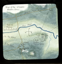
underhill17
underhill17.png
[DOWNLOAD] (Full Resolution) right-click and save link |
underhill17 Label : Map of three stone circles. 726 in Catalogue. On image: Map of the Stones Stanton Drew Image created : 1895 Period : Neolithic, Bronze Age Location : Stanton Drew, Avon, Britain |
PNG
underhill17
underhill17.png
[DOWNLOAD] (Full Resolution) right-click and save link |
5.92 Mb |
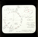
underhill31
underhill31.png
[DOWNLOAD] (Full Resolution) right-click and save link |
underhill31 Label : Plan of Stones. 727 in Catalogue. On image: STANTON DREW. From plans by C.W. Dymond 1872, 1876 Image created : Nov. 7, 1895 Period : Neolithic, Bronze Age Location : Stanton Drew, Avon, Britain |
PNG
underhill31
underhill31.png
[DOWNLOAD] (Full Resolution) right-click and save link |
4.22 Mb |
underhill28
underhill28.png
[DOWNLOAD] (Full Resolution) right-click and save link |
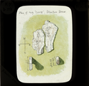
underhill28 Label : Plan of the 'COVE' Stanton Drew. 729 in Catalogue. On image: Plan of the 'COVE' Stanton Drew. Image created : 1895 Period : Neolithic, Bronze Age Location : Stanton Drew, Avon, Britain |
PNG
underhill28
underhill28.png
[DOWNLOAD] (Full Resolution) right-click and save link |
4.34 Mb |
underhill19
underhill19.png
[DOWNLOAD] (Full Resolution) right-click and save link |
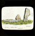
underhill19 Label : The Cove. 730 in Catalogue. On image: The 'COVE' Stanton Drew. Looking E. H.M.J.U. Image created : Nov. 1, 1895 Period : Neolithic, Bronze Age Location : Stanton Drew, Avon, Britain |
PNG
underhill19
underhill19.png
[DOWNLOAD] (Full Resolution) right-click and save link |
4.10 Mb |

underhill41
underhill41.png
[DOWNLOAD] (Full Resolution) right-click and save link |
underhill41 Label : N.E. Circle. The Altar in the middle. 728 in Catalogue. On image: H.M.J.U. Sept. 12, 1895 Image created : Oct. 14 to 19, 1895 Period : Neolithic, Bronze Age Location : Stanton Drew, Avon, Britain |
PNG
underhill41
underhill41.png
[DOWNLOAD] (Full Resolution) right-click and save link |
5.10 Mb |

underhill01
underhill01.png
[DOWNLOAD] (Full Resolution) right-click and save link |
underhill01 Label : "Wayland Smith's Cave" 2 Views. Bottom: side view. 732 in Catalogue. On image: (top) H.M.J.U. May 14, 1894 (bottom) Aug. 24, 1895 Image created : Nov. 4 to 6, 1895 Period : Location : Wayland, Oxfordshire, Britain |
PNG
underhill01
underhill01.png
[DOWNLOAD] (Full Resolution) right-click and save link |
6.21 Mb |
underhill22
underhill22.png
[DOWNLOAD] (Full Resolution) right-click and save link |
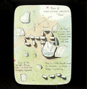
underhill22 Label : "Wayland Smith's Cave" Plan. Dolmen - Chambered Grave. 733 in Catalogue. On image: Plan of Wayland Smith's Cave. The 'Cave' is on a very low tumulus, about 100 yards across and covered with trees. There is a little bank around the tumulus, on which a hedge is growing. Some of the upright stones seem to have been roughly square. Image created : Nov. 2 to 4, 1895 Period : Location : Wayland, Oxfordshire, Britain |
PNG
underhill22
underhill22.png
[DOWNLOAD] (Full Resolution) right-click and save link |
4.26 Mb |
underhill05
underhill05.png
[DOWNLOAD] (Full Resolution) right-click and save link |
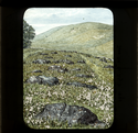
underhill05 Label : Sarsen Stones at Ashdown, nr. Uffington. 731 in Catalouge. Paint flaking damage.On image: H.M.J.U. 1895 Image created : June 24 to July 3, 1895 Period : Location : , Berkshire, Britain |
PNG
underhill05
underhill05.png
[DOWNLOAD] (Full Resolution) right-click and save link |
5.94 Mb |
underhill11
underhill11.png
[DOWNLOAD] (Full Resolution) right-click and save link |
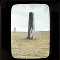
underhill11 Label : Menhir on Dartmoor. 723 in Catalogue. On image: H.M.J.U. Image created : April 25, 1895 Period : Location : Dartmoor, Devon, Britain |
PNG
underhill11
underhill11.png
[DOWNLOAD] (Full Resolution) right-click and save link |
4.79 Mb |


