
Boundary Wall of Former Cinema Site, Sandgate: Archaeological Recording Report (OASIS ID: wardella2-327338 )
Wardell Armstrong Archaeology and Cultural Heritage, 2018. https://doi.org/10.5284/1050111. How to cite using this DOI
Data copyright © Wardell Armstrong Archaeology and Cultural Heritage unless otherwise stated
This work is licensed under the ADS Terms of Use and Access.

Primary contact
Wardell Armstrong Archaeology and Cultural Heritage
Marconi Road
Burgh Road Industrial Estate
Carlisle
Cumbria
CA2 7NA
England
Tel: +44 (0) 1228 550 575
Resource identifiers
- ADS Collection: 3351
- DOI:https://doi.org/10.5284/1050111
- How to cite using this DOI
Introduction
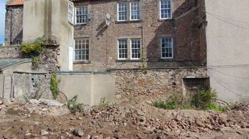
Wardell Armstrong Archaeology was commissioned by Walsingham Planning to undertake an archaeological recording of the north-west boundary wall of the former cinema site, Sandgate, Berwick-upon-Tweed (NT 99853 52699) in advance of its demolition as part of the approved and ongoing redevelopment of the site.
The report summarises the results of the site work and the accompanying archive, to be deposited in a suitable repository provides a permanent record of the structure prior to its demolition. The former cinema site as a whole has already been the subject of an archaeological desk-based assessment and evaluation in 2006 (Claydon 2006a and b), a geoarchaeological assessment (O' Meara 2015) and a heritage impact assessment (Peters 2016), and there is presently an archaeological watching brief programme in place to monitor excavations occurring within the wider site boundary as part of the redevelopment of the site. Furthermore, the north-western boundary wall itself, along with an abutting building, has been the subject of a heritage statement (Wardell Armstrong 2018). This was used to inform the planning decision for further mitigation in the form of an archaeological recording of the boundary wall prior to demolition (Planning Reference: 18/02198/FUL).
The boundary wall has been seen to have retained some historic integrity and some architectural features that have helped, along with cartographic analysis, the possible origins and evolution of the wall. The earliest fabric may retain evidence for building constructed by 1799, and the latest indicates 20th century use. This has provided an interesting insight into the changing buildings and plots utilising this central area of Berwick through the 18th, 19th and 20th centuries.
