
Where Rivers Meet: Landscape, Ritual, Settlement and the Archaeology of River Gravels
University of Birmingham, 2006. (updated 2012) https://doi.org/10.5284/1000311. How to cite using this DOI
Data copyright © University of Birmingham unless otherwise stated
This work is licensed under the ADS Terms of Use and Access.


Primary contact
Simon
Buteux
Birmingham Archaeology
University of Birmingham
Edgbaston
Birmingham
B15 2TT
UK
Tel: 0121 4145513
Fax: 0121 4145516
Resource identifiers
- ADS Collection: 492
- ALSF Project Number: 3349
- DOI:https://doi.org/10.5284/1000311
- How to cite using this DOI

Introduction
The Where Rivers Meet project is an Aggregates Levy Sustainability Fund project that is studying the archaeological resource at the confluence of the Trent and the Tame rivers in south-eastern Staffordshire. This is one of the most intensively quarried landscapes for aggregates extraction in the country. It also contains a remarkable archaeological record, beginning with well–preserved megafauna from the Late Pleistocene and including a Neolithic/Early Bronze Age ritual landscape, an Iron age and Romano–British settlement landscape, and an extensive Anglo–Saxon settlement and cemeteries. Most of our knowledge of these landscapes has arisen as a consequence of archaeological work carried out in the context of aggregate extraction.
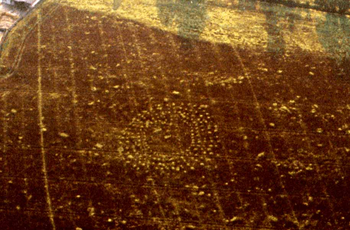
The overall study area of the project measures 6km by 12km (72 square kilometres) — this is termed the 'Full Area'. Within the Full Area a smaller 'Focus Area', covering some 235ha of land, has been designated at the physical confluence of the Trent, Tame and Mease Rivers, at Catholme Farm. The Focus Area contains an important concentration of monuments, revealed as cropmarks through aerial photography and believed on morphological grounds to comprise a complex of ritual monuments of Neolithic/Early Bronze Age date. These monuments include a 'Woodhenge' type monument consisiting of multiple rings of postholes, a 'sunburst' monument consisting of a central ring ditch with radiating pit alignments, and a very large ring ditch with apparently associated linear features. These monuments, together with a series of smaller ring ditches, a possible cursus and a series of pit alignments, are colllectively termed the 'Catholme Ceremonial Complex'.
The main phase of the Where Rivers Meet project was completed in March 2004. The project comprised a number of elements, each of which has resulted in a report.
It was part of the original design of the project that the geophysical survey of the monuments in the Focus Area should be followed up by a 'ground truthing' exercise with the principle aim of attempting to understand the sub–surface origins of the surface geophysical anomalies. Those reports were completed in October 2004 and describe the results of this exercise and include recommendations for further research and analysis.
