
Whitley Castle Geophysics Survey
Archaeological Services Durham University, 2012. https://doi.org/10.5284/1012483. How to cite using this DOI
Data copyright © Archaeological Services Durham University unless otherwise stated
This work is licensed under the ADS Terms of Use and Access.


Primary contact
Duncan
Hale
Senior Archaeologist
Archaeological Services Durham University
South Road
Durham
DH1 3LE
England
Resource identifiers
- ADS Collection: 1117
- DOI:https://doi.org/10.5284/1012483
- How to cite using this DOI


Introduction
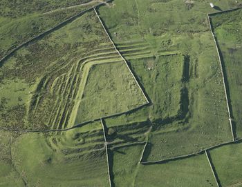
The study area covered approximately 36ha of land at Whitley Castle in Northumberland, a scheduled Roman fort (Epiacum) and its immediate surroundings, about 3km north-west of Alston (NGR centre: NY 6949 4868). The geophysical survey area was defined by a track and path (the route of the 'Pennine Way') curving around to the south, west and north of the fort, by Castle Nook Farm and the A689 road to the north and north-east, and by Whitlow to the south-east.
The geophysical surveys form part of an archaeological research project at Whitley Castle directed by English Heritage (EH). The project also included a Level 3 earthwork survey and studies of historical sources and the site's archaeological background. The principal objective of the project was to improve understanding of the monument and its setting and so inform plans for future conservation and visitor access.
In view of that objective, the specific aims of the geophysical surveys were to identify, define the extent of and, if possible, characterise any sub-surface features of potential archaeological interest.
The results of the Whitley Castle research will contribute to the wider 'Miner-Farmer Landscapes of the North Pennines AONB' project, a landscape research partnership project between EH and the North Pennines AONB, led by the EH Research Department.
