Land west of Church Road, Maisemore, Gloucestershire. Magnetometer Survey (OASIS ID: archaeol20-320069)

Archaeological Surveys Ltd, 2018. https://doi.org/10.5284/1048381. How to cite using this DOI

Digital Object Identifiers

Digital Object Identifiers (DOIs) are persistent identifiers which can be used to consistently and accurately reference digital objects and/or content. The DOIs provide a way for the ADS resources to be cited in a similar fashion to traditional scholarly materials. More information on DOIs at the ADS can be found on our help page.

Citing this DOI

The updated Crossref DOI Display guidelines recommend that DOIs should be displayed in the following format:

https://doi.org/10.5284/1048381
Sample Citation for this DOI

Archaeological Surveys Ltd (2018) Land west of Church Road, Maisemore, Gloucestershire. Magnetometer Survey (OASIS ID: archaeol20-320069) [data-set]. York: Archaeology Data Service [distributor] https://doi.org/10.5284/1048381

Data copyright © Archaeological Surveys Ltd unless otherwise stated

This work is licensed under the ADS Terms of Use and Access.
Creative Commons License


Archaeological Surveys Ltd logo

Primary contact

Kerry Donaldson
Director
Archaeological Surveys Ltd
1 West Nolands
Nolands Road
Yatesbury
Calne
SN11 8YD
Wiltshire
Tel: 01249 814231

Send e-mail enquiry

Resource identifiers

Digital Object Identifiers

Digital Object Identifiers (DOIs) are persistent identifiers which can be used to consistently and accurately reference digital objects and/or content. The DOIs provide a way for the ADS resources to be cited in a similar fashion to traditional scholarly materials. More information on DOIs at the ADS can be found on our help page.

Citing this DOI

The updated Crossref DOI Display guidelines recommend that DOIs should be displayed in the following format:

https://doi.org/10.5284/1048381
Sample Citation for this DOI

Archaeological Surveys Ltd (2018) Land west of Church Road, Maisemore, Gloucestershire. Magnetometer Survey (OASIS ID: archaeol20-320069) [data-set]. York: Archaeology Data Service [distributor] https://doi.org/10.5284/1048381

Introduction

Land west of Church Road, Maisemore, Gloucestershire. Magnetometer Survey (OASIS ID: archaeol20-320069)

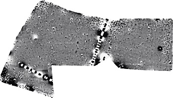
A detailed magnetometer survey was carried out by Archaeological Surveys Ltd on land to the west of Church Road, Maisemore in Gloucestershire. The results indicate the presence of a group of discrete positive responses in the central western part of the site that may relate to cut, pit-like features. Elsewhere, positive and negative linear and discrete positive responses are weak and poorly defined.

The lack of a coherent morphology does not enable them to be confidently interpreted as cut features. Other anomalies relate to modern disturbance associated with services and dumped magnetic debris.


ADS logo
Data Org logo
University of York logo