
Mapping the Medieval Townscape: a digital atlas of the new towns of Edward I
Keith Lilley, Chris Lloyd, Steve Trick, 2005. https://doi.org/10.5284/1000022. How to cite using this DOI
Data copyright © Dr Keith Lilley, Chris Lloyd, Steve Trick unless otherwise stated
This work is licensed under the ADS Terms of Use and Access.

Primary contact
Dr
Keith
Lilley
School of Geography
Queen's University Belfast
University Road
Belfast
BT7 1NN
Northern Ireland
Tel: 0208 902 73363
Fax: 0208 903 21280
Resource identifiers
- ADS Collection: 433
- DOI:https://doi.org/10.5284/1000022
- How to cite using this DOI


The Atlas
For each of Edward’s new towns the following atlas pages provide interpretative maps and text.
ArcIMS is slowly being abandoned by ESRI, so maintenance of the ArcIMS maps like these have become extremely difficult. We have decided to migrate these map interfaces to a more sustainable software stack using non-proprietary software. We will begin the migration to GeoServer and OpenLayers as soon as possible, but until then we apologise for any inconvenience.
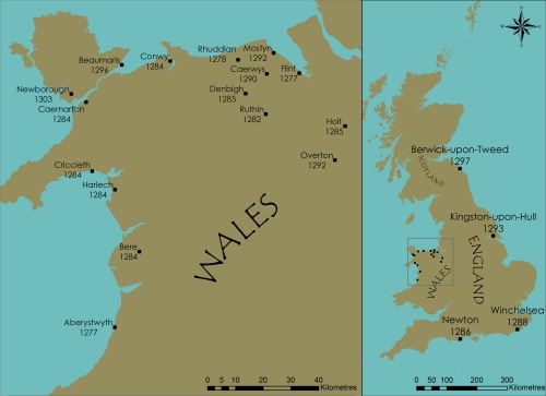
Edward’s ‘new towns’
- Aberystwyth
- Beaumaris
- Caernarfon
- Caerwys
- Conwy
- Cricieth
- Flint
- Harlech
- Holt
- Newborough
- Overton
- Rhuddlan
- Winchelsea
Information regarding other towns can also be downloaded as a PDF document.
A standard format is kept to, so that it is possible not only to study a town in its own right but also compare it with others. This should help reveal what similarities and differences there are between the thirteen towns. Such comparisons themselves might point to common aspects of their early urban histories and town planning, perhaps demonstrating connections between them. The maps to be found in these pages were discussed earlier. As far as the text is concerned, for each of the thirteen towns there is discussion firstly on the early history of the town, secondly on the town’s design and plan (its layout), and thirdly on the town as it is today.
The text on the early history of the town is a discussion drawn mainly from available historical sources and secondary works, with information about when the town was established, who was involved, and how it developed after its foundation. The aim with this is to sketch out what is known of the towns’ development up to and around 1300, the date at which they are depicted by the third of the core maps. Regarding the town’s design and plan, the focus is more on interpreting the evidence provided by studying the physical form of the urban features shown on the core maps. The aim here is to examine what the layouts of the towns reveal of their initial design, including evidence for their planning. To help provide some contemporary impression of the towns the third part of the discussion describes their character and population as they are now, some seven-hundred years after their foundation. The aim with this is to relate the medieval townscape to the modern urban landscape, pointing to those medieval features that are still visible and worthy of recognition. With all three elements of the discussion both the map-based information and historical accounts of the towns are drawn upon. To help trace the sources used in these discussions a system of footnote referencing is used which includes not only published and unpublished written work but also archaeological and cartographic sources.
An innovative aspect of this historical atlas is the links provided to GIS databases containing the layers of information that were used to create the core maps. These are accessed via an interface (ArcIMS), and archived by the Archaeology Data Service (ADS) at the University of York. To reach them simply follow the links provided. The interface is simple to use and does not require any GIS software. The database contains various map layers of source material, such as historic town plans, survey and excavation plans, architectural and building plans, primary field-survey data, and aerial imagery. As well as these source map layers there are also interpretative map layers, including the abstractions of street and building-plot patterns used to create the town plans shown by the core maps.
For each entry listed in the atlas the following summary information is provided. First, the modern, Welsh-language name of the town, the parish name (if different), and the county or shire the town is located in. Then the Ordnance Survey National Grid Reference (NGR), the type of town, and historical data. The type of town is based on a simple classification system that identifies whether a town was a ‘castle town’ or a ‘market town’, created with or without defences. The term castle town is used whether or not the castle pre-dated the town or was constructed at the same time as the town’s foundation, while ‘market town’ is used to differentiate between those new towns that had more of a military role from those towns whose function was solely commercial. Defences may also either be contemporary with the town’s foundation or established later. The historical data is derived from contemporary written sources, and include the date at which the first market or borough charter is recorded, and the number of the town’s burgages, burgesses, or taxpayers given in surviving rentals or accounts. The latter provides an indication of the population size at given a date, those selected here being the earliest documented figures. A ‘burgage’ was the property rented by a ‘burgess’ according to the customs and privileges set out in a town’s borough charter. The physical size of a burgage is occasionally stipulated. Where this is the case it is noted. Burgess and taxpayer figures provide an approximate estimate of urban population size, but because not every inhabitant of a town was a burgess or a taxpayer the actual population total would have been higher (by a factor of about 4-6). Also, the number of burgages recorded usually only includes those which were either occupied by a burgess or being rented by them. The total number of burgages laid out in a town at the time of its foundation could easily have been higher. To confuse matters even further, sometimes one burgess could rent more than one burgage, or one burgage may become subdivided and held by more than one burgess, so the burgage and burgess figures may not always tally. So these historical sources can be traced, references are provided in the historical essays. Two dimensions are also given, the area of the town and its overall length/breadth as measured along two main axes (usually the main streets). The calculations are based on field survey data gathered in 2004 and are approximate for the towns as they were at around 1300.
[top]
A note on units of measurement and money
Measurements of area and length in the atlas entries are given in imperial units (ie. acres, feet) with their metric equivalents (ie. hectares, metres). Monetary values are in pounds (£), shillings (s) and pence (d). Twelve pence made a shilling and twenty shillings a pound. As a guide to value of currency, at the end of the thirteenth century a carpenter’s daily wage was around two and a half pence, and while a labourer might earn thirty shillings a year, an aristocratic lord, such as an earl, could have an income of around £5000 a year.
[top]
