
Stourbridge Sand Caverns, West Midlands. Archaeological Survey
Birmingham Archaeology, 2017. https://doi.org/10.5284/1046303. How to cite using this DOI
Data copyright © University of Birmingham unless otherwise stated
This work is licensed under the ADS Terms of Use and Access.

Primary contact
Historic England
1 Waterhouse Square
138-142 Holborn
London
EC1N 2ST
UK
Tel: 01793 414700
Fax: 01793 414707
Resource identifiers
- ADS Collection: 2934
- DOI:https://doi.org/10.5284/1046303
- How to cite using this DOI


Introduction
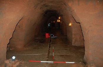
Birmingham Archaeology was commissioned in November 2008 by the Engineer’s Department of Dudley Metropolitan Borough Council, to carry out an Archaeological Survey of a series of sandstone caverns located below St. John’s Road, Stourbridge, West Midlands (centred on NGR SO 90150 84545). The caverns were due to be backfilled following a condition assessment of early 2008, which raised serious concerns regarding the long term stability of the complex.
The caverns have been the subject of a previous Archaeological Desk-Based Assessment which established that the area of the caverns remained essentially undeveloped until the middle years of the 19th century, when expanding industrialisation gradually encroached onto an area of former fields and gardens. A brewery (the Stourbridge Brewery) was established by a Mr. John Wall, formerly a maltster, at some point between 1837 and 1851, occupying the area directly above the cavern complex. The caverns are commonly held to have been originally excavated as cellarage for this brewery but, though probable, no documentary sources have been identified to definitively support such a conclusion and their origins remain somewhat obscure. They certainly seem to have been sited to exploit the proximity of the Stour River, Stourbridge Canal, the railway goods yards and associated communication networks, either for the receipt of incoming raw materials or for the export of finished products. The Stourbridge Brewery was amalgamated in 1886 to form the North Worcestershire Breweries Company, subsequently being taken over by Wolverhampton and Dudley Breweries and closed soon after 1910, at which time the caverns became obsolete and were abandoned. During World War II, the complex of caverns was refurbished to function as air raid shelters for use by the general public and by pupils and staff of the King Edward VI Grammar School. Following the end of the war, the caverns were once again closed and partially infilled.
The survey has allowed for a detailed survey and photographic record of the cavern system to be made in advance of backfilling, while the use of laser scanning for the base survey allowed for the creation of full, 3-dimensional model of the complex to be generated.
