The Excavation of the Southern Defences of the Caerleon Legionary Fortress 1982
Howard Mason, Philip Macdonald, H. E. M. Cool, 2010. https://doi.org/10.5284/1000161. How to cite using this DOI
Data copyright © Cadw unless otherwise stated
This work is licensed under the ADS Terms of Use and Access.
Primary contact
Richard
Turner
Inspector of Ancient Monuments
Cadw
Plas Carew Unit 5/7
Cefn Coed
Nantgarw
Cardiff
CF15 7QQ
Wales
Tel: 01443 336012
Fax: 01443 336001
Resource identifiers
- ADS Collection: 987
- DOI:https://doi.org/10.5284/1000161
- How to cite using this DOI
Overview
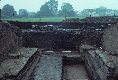
The area available to be excavated was governed by the needs of the consolidation work and was thus effectively confined to the area of the wall and rampart. There was no opportunity to explore either the berm and ditch in front of the wall or the area at the rear of the rampart, though the edges of some buildings in the latter area were recorded. The excavations took place in five areas Sites A and D were those of the corner and interval turrets respectively. Site C was a machine dug trench across the rampart which in part duplicated the section dug in 1909, whilst Site B was a new machine dug section across the rampart. The proposed re-display of the defences involved the demolition of a Second World War fortification on the top of the rampart to the north-west of the corner tower. This allowed the excavation of the surface of the rampart in Site E which linked Sites A and C.

Seven phases of activity were recorded. Phase I was the original earthen rampart of the fortress and clear evidence for the turf revetment stacks on either face were recovered. The areas dug produced little direct dating evidence but it is assumed that the rampart was one of the first elements of the fortress to be built which would date it to the AD 74-5 period.
Phase II was the construction of the stone rampart wall and turrets. Clear evidence that both the wall and the turrets were planned and built as a single scheme was recovered. There was good evidence that the rampart walls were originally rendered white with false jointing picked out in red paint. An unworn as of AD 86 from the foundation trench of the interval tower provided a terminus post quem for the building work. Very soon after completion, the paved floor of the interval turret was removed and the ground floor room was used as a rubbish dump (Phase III). The date of the objects included in the dumps indicate that this activity had started by the early years of the second century. Combined with the coin from the foundations, this indicates that the rebuilding in stone must have taken place during the late 80s or 90s. The dumping of rubbish and oven debris continued into the later second century.
Phase IV consisted of two separate episodes when the rampart wall was replaced. The need to carry out this work had probably been brought about by instability caused by the drainage system. This is the lowest-lying part of the fort and a major drain discharged in the area. No direct dating evidence of when these rebuilding episodes occurred was recovered.
Parts of four unrelated building were found cut into the back of the rampart and were described as Phase V. They included a latrine, a building of unknown function, possible cooking ovens and a cookhouse. The last-mentioned being built after the interval tower dumping had finished. Alterations to the rampart consisting of deposits to broaden and level it were observed on Site E (Phase VI). Such dating evidence as there was suggested this activity took place in the early to mid third century. Late third and fourth century material was conspicuous by its absence throughout the excavations.
Phase VII consisted of various post Roman episodes. The stone of the turrets was robbed out in the eighteenth century and in 1940 a non-standard brick-built emplacement was built on top of the rampart as part of the Second World War fortifications prepared for the Home Guard.


