
Land East of Lower Road, Stoke Mandeville, Buckinghamshire: Archaeological Evaluation (OASIS ID: cotswold2-317198)
Cotswold Archaeology, 2018. https://doi.org/10.5284/1048313. How to cite using this DOI
Data copyright © Cotswold Archaeology unless otherwise stated
This work is licensed under the ADS Terms of Use and Access.

Primary contact
Cotswold Archaeology
Building 11
Kemble Enterprise Park
Cirencester
GL7 6BQ
UK
Tel: 01285 771022
Fax: 01285 771033
Resource identifiers
- ADS Collection: 3246
- DOI:https://doi.org/10.5284/1048313
- How to cite using this DOI
Introduction
In February and March 2016, Cotswold Archaeology carried out an archaeological evaluation of land to the east of Lower Road, Stoke Mandeville, Buckinghamshire. The results of the evaluation, which was commissioned by CgMs Consulting, acting on behalf of Gladman Developments Ltd, will be submitted in support of an outline planning application to Aylesbury Vale District Council for the residential development of the land.
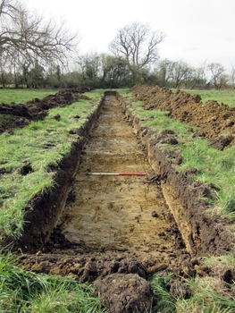
The trenches were distributed across three pasture fields on the northern edge of the modern village. Previous geophysical survey of the site had identified a series of furrows of medieval/post-medieval date; extant ridge and furrow earthworks were still evident in the western and central parts.
The evaluation revealed a concentration of poorly dated but probable late prehistoric features in trenches in the north-eastern corner of the site, features that were not detected by the geophysical survey. The features comprised part of a rectilinear ditch system, probably a sub-divided enclosure of at least two phases, along with pits and at least one, but probably two curvilinear ditches, possibly the remains of roundhouses. There was no dating evidence to securely date these features, but they were sealed by the subsoil suggesting that they probably predate the medieval period. Other undated features across the site may be the remains of an outlying field system associated with the settlement, though their sparse distribution prevents any definitive interpretation.
Medieval/post-medieval furrows were identified in trenches across the site and their alignments suggest that the site covers parts of two former open fields.
