
A Viking-age cemetery at Cumwhitton, Cumbria.
Oxford Archaeology North, Historic England, 2015. https://doi.org/10.5284/1031499. How to cite using this DOI
Data copyright © Oxford Archaeology North, Historic England unless otherwise stated
This work is licensed under the ADS Terms of Use and Access.

Primary contact
Oxford Archaeology (South)
Janus House
Osney Mead
Oxford
OX2 0ES
UK
Tel: 01865 263800
Fax: 01865 793496
Resource identifiers
- ADS Collection: 1973
- DOI:https://doi.org/10.5284/1031499
- How to cite using this DOI

Overview
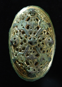
Oval brooch which led to the
discovery of the site
© Oxford Archaeology Ltd
The site consisted of six graves, which were renumbered during the publication process for ease of identification and reference in the published material. Many objects from the site were lifted in soil blocks, which following micro-excavation by English Heritage at Fort Cumberland, were found to contain multiple objects. These were originally numbered in accordance with the soil blocks but after conservation they were renumbered in the finds database. The graves are referred to by their original context numbers in the archive, and a concordance table with the published material is provided below for ease of reference.
| Published grave numbers | Original context |
| Grave 1 | Gr 4 or 85 |
| Grave 2 | Gr 27 |
| Grave 3 | Gr 24 |
| Grave 4 | Gr 36 |
| Grave 5 | Gr 25 |
| Grave 6 | Gr 32 |
Included within the downloads section are the figures produced for the assessment, all fully georeferenced, and the associated CAD plans of individual features and site plans. The file 'Final_plan.dwg' is a composite of the features, limits of excavation, geophysical interpretive plots, grave and feature cuts, and the location data plots for all the objects and artefacts, and 'contour.dwg' contains the georeferenced contour data, which were the result of a topographic survey conducted on the site.
The 'finds data table' within the database in the downloads section is the final output version, listing all the objects, renumbered after their return from Fort Cumberland, their material, and context associations.
The images portion of the downloads section are named by the original grave context, which concords with the published sequence outlined above.
The Rectified Photographs are submitted in two versions: Rectified (Raw) and Rectified (Combined). The raw files are the individual photographs taken on site, unadulterated; and the combined ones are the composite rectified images of the graves and features. Within the X-rays portion of the images section are the X-rays of the objects, divided by those from the graves, and those found within the ploughsoil of the field. These are named by the original grave context number, and then the x-ray code. The original X-rays are held by Tullie House Museum and Art Gallery in Carlisle.
