
England's Historic Seascapes: Southwold to Clacton
Oxford Archaeology (South), 2007. https://doi.org/10.5284/1000277. How to cite using this DOI
Data copyright © Historic England unless otherwise stated
This work is licensed under the ADS Terms of Use and Access.


Primary contact
Oxford Archaeology (South)
Janus House
Osney Mead
Oxford
OX2 0ES
UK
Tel: 01865 263800
Fax: 01865 793496
Resource identifiers
- ADS Collection: 746
- ALSF Project Number: 4729
- DOI:https://doi.org/10.5284/1000277
- How to cite using this DOI
England's Historic Seascapes:
Southwold to Clacton
ALSF Project Number 4729
Oxford Archaeology, 2007
Aldeburgh Coastal Waters
Primary Subcharacter Type:
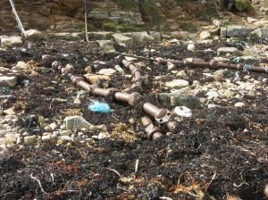
Submarine cable/pipeline
Main Character / current form and use
The character of the Aldeburgh Area Coastal Waters is somewhat mixed. The character area has a large industrial component in the form of coastal shipping and the presence of a high number of submarine cables and pipelines. In addition the area is used for recreational sailing and other water-based recreational activities due to its proximity to the Suffolk Heritage Coast.
Shipping follows the coastal route in evidence around the whole coastline of the study area and includes vessels such as cargo and bulk ships, ferries, gas carriers and tankers. The northern half of the area falls within the jurisdiction of Great Yarmouth Port Operations and is a precautionary area due to submarine cables and pipelines and changing depths. The southern half, in contrast, is within the reach of Harwich Haven Authority and is subject to restrictions concerned with high speed craft, submarine cables and traffic separation and is covered by Vessel Traffic Services (VTS).
Submarine cables and pipelines include Concerto North and South which connect the UK to the Netherlands and Belguim and are maintained by Interoute and Flute Ltd, Hermes 1 maintained by GTS Network Services and Farland North which connects Aldeburgh to Domburg in Holland. Additionally a number of intake and outfall pipes and disused cables are located within the character area close to the coast, making landfall at Sizewell, Thorpeness and Aldeburgh.
The area has widely varying depth ranges, mainly decreasing towards the coast from 20-30 m to 2-5 m. However, depths are not uniform and areas of deeper and shallower water exist throughout. The tidal range in the character area is within the range of 2-3 m at Mean Spring Tide (DTI 2004). The area is notable for a number of natural features, important to use of the sea. These include Sizewell Bank, Aldeburgh Napes and Aldeburgh Ridge / Onion. All present a navigational hazard to shipping, Aldeburgh Ridge is marked by a light buoy, though incidents of grounding still occur, as recorded by Aldeburgh lifeboat (http://aldeburghlifeboat.org.uk/services7.html). An area of water turbulence is located immediately to the east of Aldeburgh Napes, noticeably correlating with a number of the known wrecks in this area. In general the geology of the area is a mixture of gravel and gravelly muddy sand.
An outcrop of bedrock (Pleistocene Coralline Crag) also exists off the Thorpeness headland. This type of feature is unusual off this area of coast and attracts local sealife. As such it is extensively fished for crabs and lobsters by local fishermen and may be of scientific interest (Moore and Bamber 1995). Commercial fishing also takes place over Aldeburgh Napes.
Additionally three Royal Yacht Association (RYA) routes cross the area, one is immediately coastal, the second in deeper water though still following the coast, the third links the two together. The area is also a potential recreational dive site.
Historic Character and archaeological potential
The area has been a navigational hazard for shipping for a number of years and the sandbanks discussed above are all marked on Admiralty charts dating to 1855 and 1905. The Ipswich Journal of January 16th 1742 records that "Yesterday morning his Majesty's Sloop the Otter, Capt Gordon, was lost on Sizewell Bank, the captain and 36 others were drowned, only 18 escaped." (http://www.foxearth.org.uk/1740-1745IpswichJournal.html)
Overall, 33 known wrecks are located in the character area, 25 of which are considered dangerous. The majority of named wrecks were mined or sunk by enemy submarines. These include three Royal Navy vessels, HMS Tervani, HMS Dane and HMS Hirose. Both coastal and international voyages are represented among the known losses. For example, the Friargate was carrying 225 tons of loam from London to Middlesborough, the Ingstad was carrying coal from the Tyne, bound for Nantes
The potential for shipwreck archaeology in the character area is quite high. In addition, the area has potential to contain submerged prehistoric landscapes, features or artefacts, having been dry land prior to 8000 BP, particularly considering the location of the area close to the present day coastline in an area which may have been coastal for thousands of years. However, no investigation work is known to have been done in this area.
Character perceptions
The area is perceived as industrial due to its proximity to the Sizewell Nuclear Power station which may explain the presence of numerous cables and pipelines. It is also important to shipping communities as part of the main coastal route around East Anglia. The area is significant to local fishermen, especially from Aldeburgh who fish the reef off Thopeness and the sandbanks.
Bibiliography
DTI, 2004, Mean Spring Tidal Range: Atlas of UK Marine Renewable Energy Resources. Department of Trade and Industry, 2004
Moore, J. & Bamber, R., 1995, Diving Survey of an Unusual Rocky Habitat off Thorpeness Point, Sizewell, Suffolk. Porcupine Newsletter, 5 (10): 239-245
Aldeburgh Inshore Lifeboat Service Calls. Available at: http://aldeburghlifeboat.org.uk/services7.html (15/03/2007)
Ipswich Journal. Available at: http://www.foxearth.org.uk/1740-1745IpswichJournal.html (15/03/2007)
Wikipedia. Available at: http://en.wikipedia.org (15/03/2007)
