
England's Historic Seascapes: Southwold to Clacton
Oxford Archaeology (South), 2007. https://doi.org/10.5284/1000277. How to cite using this DOI
Data copyright © Historic England unless otherwise stated
This work is licensed under the ADS Terms of Use and Access.


Primary contact
Oxford Archaeology (South)
Janus House
Osney Mead
Oxford
OX2 0ES
UK
Tel: 01865 263800
Fax: 01865 793496
Resource identifiers
- ADS Collection: 746
- ALSF Project Number: 4729
- DOI:https://doi.org/10.5284/1000277
- How to cite using this DOI
England's Historic Seascapes:
Southwold to Clacton
ALSF Project Number 4729
Oxford Archaeology, 2007
Clacton Area
- Clacton Area
- 'Clactonian'
- Clacton
- Frinton-on-Sea
- Jaywick
- Martello Tower
- The Lyonesse Surface
- Walton-on-the-Naze
Primary Subcharacter Type:
Seaside leisure area
Main Character / current form and use
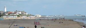
The Clacton area extends along the coast, from the Naze in the north to Jaywick Sands in the south and includes the immediate coastal waters of the region. The area is predominantly characterised as a recreational leisure area, dominated by the coastal resort of Clacton-on-Sea (see link) but also encompassing Walton-on-the-Naze (see link), Frinton-on-Sea (see link), Holland-on-Sea and Jaywick (see link). The area as a whole is known as the �Sunshine Coast� and is famous for its sandy beaches, piers and amusement arcades, as well as more traditional features such as beach huts and coastal walks and architecture. The area also contains Holland Haven Country park which has status as an SSSI. This comprises unspoilt grazing marshes with footpaths, cliff-top walks, access to beaches and birdwatching for visitors. The SSSI designation recognises the rare and varied flora of the area.
As part of this character, recreational fishing takes place off Clacton Pier, Walton pier and beaches at Jaywick, Frinton and Holland-on-Sea. The offshore area is a potential recreational dive site and is popular for swimming and watersports, particularly windsurfing at Jaywick.
The area rests upon the foundation of the London Clay. The cliffs within this area are composed of a series of Pleistocene gravels, sands and clays which represent the deposits of a much older course of the Thames (D�Olier 2002). Offshore, the maximum depth in the area is 5 m. The tidal range is within the range of 4-5 m at Mean Spring Tide (DTI 2004).
The area has a small fishing industry based mainly at Clacton and Walton which includes trawling, netting, longlining and potting (KESFC). The catches of sole, roker, cod and shellfish are mainly sold to the public.
Historic Character and archaeological potential
The area has a rich maritime history and remarkable archaeological potential. Clacton is a very significant Palaeolithic site and gives its name to a flint tool industry (see link). Evidence also indicates a series of coastal settlements dating from the Mesolithic to the Bronze Age period, associated with the 'Lyonesse surface' (see link). Settlement generally moved away from the coastline after this point in the Prehistoric. Considering this there is potential for Prehistoric settlement both in the intertidal and marine zones of this character area, possibly in the form of submerged landscapes.
Roman activity along the coastline was limited to Red Hills indicating salt working was taking place. In addition a shore fort was built at Walton in its location during this period. The fort is now lost to the sea, though some exploration has been carried out (Bacon pers com). The fort appeared to continue as a keep into the Middle Ages, as records indicate Henry II ordered the keep to be dismantled in 1174 after the baron's rebellion. However, Edward III was said to have stayed at the castle en route to Crecy in 1338, therefore some settlement must have remained (Bacon per com).
During the Saxon period and later the land in this area was owned by the chapter of St Pauls cathedral and an area of the coast, made up of Walton, Kirby and Thorpe were known as the Soken. This area was granted special privileges and powers. The Soken was conveyed to Henry VIII in 1545.
The character area was generally farmland and small hamlets next to the sea until the 20th century when seaside recreation became popular. Much of the land was then purchased by wealthy individuals who planned to create coastal resorts, aided by the construction of railways. It can be argued that Clacton, Walton and Frinton owe their existence entirely to the railways (Williamson 2006, 125). This seaside heyday was cut short by WW2 and has been affected in recent years by the popularity of foreign holidays.
Built maritime heritage is significant in the character area, mainly in the form of coastal defences. A series of five Martello Towers (see link) were built between 1810 and 1812 along the coastal strip. World War II defences include a number of pillboxes and underground monitoring posts. In addition 56 listed buildings survive in the area as a whole.
Character perceptions
The character area is perhaps best known as the 'Sunshine Coast', commonly perceived as a retreat for Londoners with its sandy beaches and numerous amusement arcades. It is also known for its archaeology and fossils, occasionally well preserved within the London Clay and associated layers.
Bibiliography
DTI 2004, Mean Spring Tidal Range: Atlas of UK Marine Renewable Energy Resources. Department of Trade and Industry, 2004
D'Olier, Wallingford, B. H. R., 2002, Southern North Sea Sediment Transport Study, Phase 2 (appendix 10). Technical Report. CEFAS/UEA
Strachan, D., 1998, Essex from the Air, Essex County Council
Williamson, T., 2006, England's Landscape: East Anglia. English Heritage
Wilkinson, T. J. & Murphy, P. L., Essex: 1995, The Archaeology of the Essex Coast , Volume 1: The Hullbridge Survey Project. Essex County Council, Archaeology Section
Daves Jaywick Website. Available at: http://www.jaywick.net/ (15/03/2007)
Tour of Clacton on Sea: Clacton�s Largest Independent Tourist Information Website. Available at: http://www.clactontour.co.uk/ (15/03/2007)
Kent & Essex Sea Fisheries Committee, pers. comm.
Wikipedia. Available at: http://en.wikipedia.org (15/03/2007)
