
England's Historic Seascapes: Southwold to Clacton
Oxford Archaeology (South), 2007. https://doi.org/10.5284/1000277. How to cite using this DOI
Data copyright © Historic England unless otherwise stated
This work is licensed under the ADS Terms of Use and Access.


Primary contact
Oxford Archaeology (South)
Janus House
Osney Mead
Oxford
OX2 0ES
UK
Tel: 01865 263800
Fax: 01865 793496
Resource identifiers
- ADS Collection: 746
- ALSF Project Number: 4729
- DOI:https://doi.org/10.5284/1000277
- How to cite using this DOI
England's Historic Seascapes:
Southwold to Clacton
ALSF Project Number 4729
Oxford Archaeology, 2007
Deben Estuary
Primary Subcharacter Type:
Protected area
Main Character / current form and use
The predominant character of the Deben estuary is its recreational function. This applies to its status as a protected area and as a popular sailing route. The intertidal mudflats and saltmarsh are designated Special Protection Areas (SPA) and RAMSAR (internationally significant wetlands). As much as one third of all the salt marsh in Suffolk lies within the Deben Estuary. The southern part of the character area falls within Essex, whilst the northern part lies in Suffolk, and as such is part of the Suffolk Heritage Coast and the Suffolk Coast and Heath Area of Outstanding Natural Beauty (AONB). It is designated as a Natura 2000 internationally important marine site because of its rare birdlife.
The river is navigable for more than 10.5 miles from the estuary mouth to Wilford Bridge. The area's significance to the sailing community is evident in the town of Woodbridge at the head of the estuary and the hamlet of Waldringfield on the southern bank.
Woodbridge was once an important trading centre and retains its thriving boat building industry. Waldringfield comprises a series of houses built alongside the estuary with parallel docks and a small beach. Most of the river is covered by byelaws from May to September. The estuary comes within the jurisdiction of Harwich Haven Authority and consequently is subject to a number of precautionary zones such as high speed craft, submarine cables, traffic separation and is covered by vessel traffic services.
The Deben is strongly contained by man-made defences with quite broad flood plains and the entrance an be treacherous where the banks shoal and the depth ranges from 0m to 5 m. This restricts the type of traffic it can support and retains its essentially rural character. A total of 23 wrecks and two possible wrecks are known within the area, in addition to a number of other obstructions including piles and posts.
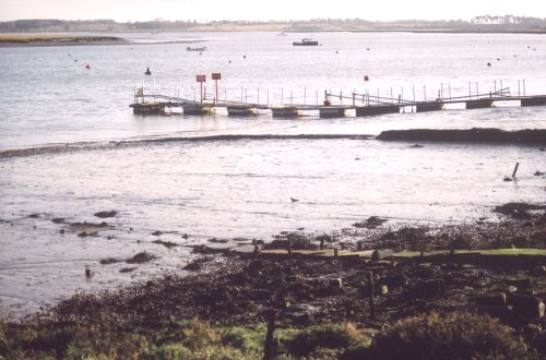
Caption: View of Deben estuary from Waldringfield
Photo courtesy: Oxford Archaeology
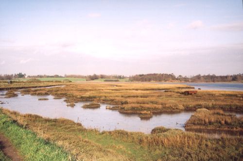
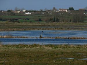
Caption: View of saltmarsh to the north-west of Waldringfield on the Deben estuary
Photo courtesy: Oxford Archaeology
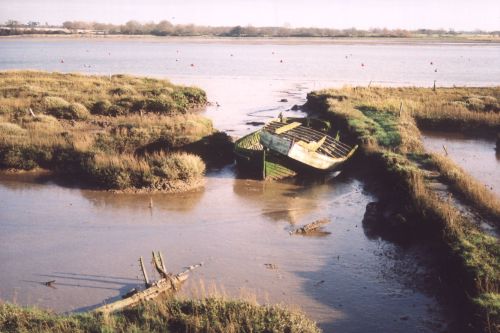
Caption: View of a hulk in saltmarsh in the River Deben estuary, north-west of Waldingfield
Photo courtesy: Oxford Archaeology
Historic Character and archaeological potential
The archaeological potential of the area is high. Settlement evidence dates back as far as the Mesolithic in the form of flint implements found on the shore of Ramsholt cliff. Estuaries are generally perceived to be 'hotspots' for locating submerged prehistoric archaeology particularly dating to the Mesolithic. The site of Sutton Hoo, on the banks of the Deben, famous for its Anglo-Saxon burials has also produced evidence of activity as early as the Neolithic.
The area was significant in the medieval period and may have been the centre of the Anglian kingdom of East Anglia (Wren 1976, 188). The medieval port of Woodbridge developed from the Anglo-Saxon area of 'Goseford' which comprised a number of settlements. The town was known for building merchant ships and men of war for the navy from 1500 to 1850 (Wren 1976, 189) and area enjoyed coastal and continental trade until the railway opened in the 19th century, gradually killing trade. The port also decayed as a result of silting of the river and the sandbar at the mouth of the estuary. A tidal mill is known to have existed in Woodbridge from the 12th century and one still stands at the head of the Deben today (see link).
Further down the estuary Waldringfield was an industrial centre for coprolite in the 1700s and cement production and export in the 19th century but the industry became redundant in 1907. The remains of a quay built for this purpose survives at Waldringfield (see link).
The Martello tower (see Link) at Felixstowe Ferry is a scheduled monument. Prior to the construction of the Martello tower a floating battery with four guns was stationed at the mouth of the Deben for defensive purposes.
The character area was also important defensively in the 20th century, with military installations placed in a strategic position on the east coast, including RAF Bawdsey (see link).
Character perceptions
Like the Stour Estuary, the Deben is recreational and tourism dominated. It is renowned for its tranquillity and wildlife and perceived as a hotspot for recreational sailing. The area has become particularly upmarket in recent years. The estuary head is dominated by the picturesque town of Woodbridge which contains a range of standing medieval and earlier post-medieval buildings.
The tranquillity of the area is important to the local community and 'Deben Watch' was established in 2004, encouraging people to report crimes, collisions and irresponsible behaviour on the river.
Bibiliography
Suffolk County Council, 2006, Suffolk Intertidal Field Survey Assessment Report, v. 1. Suffolk County Council
Wren, W. J., 1976, Ports of the Eastern Counties: The Development of Harbours on the Coast of the Eastern Counties From Boston in Lincolnshire to Rochford in Essex. Dalton
Bawdsey Radar Group. Available at: http://www.bawdseyradargroup.co.uk/ (15/03/2007)
