
England's Historic Seascapes: Southwold to Clacton
Oxford Archaeology (South), 2007. https://doi.org/10.5284/1000277. How to cite using this DOI
Data copyright © Historic England unless otherwise stated
This work is licensed under the ADS Terms of Use and Access.


Primary contact
Oxford Archaeology (South)
Janus House
Osney Mead
Oxford
OX2 0ES
UK
Tel: 01865 263800
Fax: 01865 793496
Resource identifiers
- ADS Collection: 746
- ALSF Project Number: 4729
- DOI:https://doi.org/10.5284/1000277
- How to cite using this DOI
England's Historic Seascapes:
Southwold to Clacton
ALSF Project Number 4729
Oxford Archaeology, 2007
Deep Sea Route
Primary Subcharacter Type:
Shipping lane
Main Character / current form and use
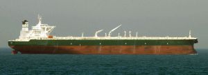
The Deep Sea Route is primarily a deep water shipping route immediately adjacent to the median line with Holland in the north eastern sector of the study area. It is traversed by a wide variety of shipping types including ferries, bulk and cargo vessels, gas carriers and tankers (Jones et al nd). Part of the eastern side of the area is avoided by shipping as a result of the two-way deep water route in place in this region. In addition the northern part of the character area is within a larger caution area due to pipelines and is covered by Vessel Traffic Services (VTS).
The majority of the character area falls within the depth range of 30-50 m, though isolated pockets of seabed 20-30 m deep exist in the south and an area 50-100 m deep is located in the northwest corner. The overlying geology is gravelly muddy sand with the exception of one isolated patch of gravel. The tidal range in the character area is mainly within the range of 1-2 m at Mean Spring Tide (DTI 2004).
The submarine cable known as Hermes1 maintained by GTS Network Services traverses the north of the area.
Historic Character and archaeological potential
Little is known about the historic character of the area, which is in many cases too far offshore to be included on historic Admiralty charts. The area was defensively mined as part of a large coastal barrier during WW2 (Foynes 1994).
In total 24 wrecks are known to be located within this character area, twelve of which are considered to be dangerous. Vessels including the Konigin Wilhelmina, Maas, Poolster and HMS Amphion were sunk by mines. Pluto and E & C were sunk by submarines.
The potential therefore exists for shipwrecks. Any surviving vessels may be well preserved as a consequence of their depth. In addition the area has potential to contain submerged prehistoric landscapes, features or artefacts, having been dry land prior to 8000 BP. No investigative work is known to have been carried out in this area, although a number of Mesolithic worked bone and antler implements have been dredged up by fishermen directly north and east of this area in the area around the feature known as Brown Bank. It is thought that these represent the remains of coastal settlement in this area, possibly sheltered behind a coastal barrier (now Brown Bank) (Louwe Kooijmans 1970-1971).
Character perceptions
The Deep Sea Route Area is generally known to the shipping community as a continental sea route and is recognised as a two-way traffic region. As an area of open sea, approximately 65 km from the Suffolk coast the area is unlikely to be known by local land-based communities. Currently available information indicates the area has not been intensively investigated.
Bibiliography
DTI, 2004, Mean Spring Tidal Range: Atlas of UK Marine Renewable Energy Resources. Department of Trade and Industry, 2004
Foynes, J. P., 1994, Battle of the East Coast (1939-1945). J. P. Foynes
Jones, L. A., Coyle, M. D., Evans, D., Gilliland, P.M., & Murray, A. R., Southern North Sea Marine Natural Area Profile: A contribution to regional planning and management of the seas around England. Peterborough: English Nature.
Louwe Kooijmans, L. P., 1970-71, Mesolithic bone and antler implements from the North Sea and from the Netherlands. Ber Rijksdienst oudheidk. bodemonderz. 20/21, 27-73, plus plates
Wikipedia. Available at: http://en.wikipedia.org (15/03/2007)
