
England's Historic Seascapes: Southwold to Clacton
Oxford Archaeology (South), 2007. https://doi.org/10.5284/1000277. How to cite using this DOI
Data copyright © Historic England unless otherwise stated
This work is licensed under the ADS Terms of Use and Access.


Primary contact
Oxford Archaeology (South)
Janus House
Osney Mead
Oxford
OX2 0ES
UK
Tel: 01865 263800
Fax: 01865 793496
Resource identifiers
- ADS Collection: 746
- ALSF Project Number: 4729
- DOI:https://doi.org/10.5284/1000277
- How to cite using this DOI
England's Historic Seascapes:
Southwold to Clacton
ALSF Project Number 4729
Oxford Archaeology, 2007
East of Orford Ness
Primary Subcharacter Type:
Dumping ground (military)
Main Character / current form and use
The East of Orford Ness area is mainly characterised as a commercial shipping route. This particularly applies to coastal traffic, with deep water traffic generally crossing further out to sea. As such, the western part of the character area has denser shipping routes, mainly going to and from the Thames Estuary. The type of vessels known to transit the area include ferries, gas carriers, tankers, bulk and cargo ships (Jones et al nd). The area comes under the jurisdiction of Great Yarmouth Port Operations and is a precautionary area due to submarine cables and changing depths.
The main depth range over the character area is 20-30 m, with isolated areas as deep as 30-50m. An unnamed sandbank is located in the east of the area, the depth over which is as little as 10-15 m. The overlying geology of the area is predominantly gravelly muddy sand. The tidal range is within the range of 2-3 m at Mean Spring Tide (DTI 2004).
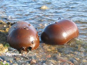
Secondary features of the East of Orford Ness Area include a disused explosives dump and a number of submarine cables. The explosives dump, known as 'East of Orford Ness' takes advantage of a deeper part of the area. Such marine disposal of surplus munitions has been widespread in the coastal waters of the British Isles. There is no statutory regulation of access to these areas and some are regularly fished (Rogers 1997).
Submarine cables include Concerto North and South which connect the UK to the Netherlands and Belguim and are maintained by Interoute and Flute Ltd, Hermes 1 maintained by GTS Network Services and Farland North which connects Aldeburgh to Domburg in Holland.
The west and south of the area are also a potential recreational dive sites.
Historic Character and archaeological potential
The unnamed sandbank to the west of the area does not appear on historic charts and as such there is no historic reference to this character area. However, 89 wrecks are known to be located within the area. Of the named wrecks the majority are mined and two were sunk by submarines indicating the area was heavily mined during the World War 2. A total of 64 of the wrecks are considered dangerous. Known wrecks include Royal Navy vessels HMS Waveflower, HMS New Comet, HMS Holdene, HMS Adonis, HMS Eros, HMS Sisters Melville and HMS River Clyde. Other vessels such as Ostprussen, Torchbearer, Vae Victis and Lonada were undertaking coastal voyages which illustrates the importance of this area for coastal trade historically. International voyages are represented by vessels such as Dagmar, Kwasind, Petshenga and Mendibil Mendi.
The potential for shipwreck archaeology in the character area is therefore high, with many concentrated in the western part. In addition, the area has potential to contain submerged prehistoric landscapes, features or artefacts, having been dry land prior to 8000 BP. However, no investigation work is known to have been done in this area.
Character perceptions
The character area is perceived as an area of open sea which will be well-known by those undertaking coastal shipping but is unlikely to be recognised by land-based communities on the Suffolk coast, some 9 km to the west. The explosives dump appears to contribute little to how the area is viewed with sea-users treating the area as any other.
Bibliography
Department of Trade and Industry, 2004, Mean Spring Tidal Range: Atlas of UK Marine Renewable Energy Resources. Department of Trade and Industry
Jones, L. A., Coyle, M. D., Evans, D., Gilliland, P.M., & Murray, A. R., Southern North Sea Marine Natural Area Profile: A contribution to regional planning and management of the seas around England. Peterborough: English Nature.
Rogers, S. I., 1997, A review of closed areas in the United Kingdom Exclusive Economic Zone. CEFAS Science Series Technical Report No. 106
Wikipedia. Available at: http://en.wikipedia.org (15/03/2007)
