
England's Historic Seascapes: Southwold to Clacton
Oxford Archaeology (South), 2007. https://doi.org/10.5284/1000277. How to cite using this DOI
Data copyright © Historic England unless otherwise stated
This work is licensed under the ADS Terms of Use and Access.


Primary contact
Oxford Archaeology (South)
Janus House
Osney Mead
Oxford
OX2 0ES
UK
Tel: 01865 263800
Fax: 01865 793496
Resource identifiers
- ADS Collection: 746
- ALSF Project Number: 4729
- DOI:https://doi.org/10.5284/1000277
- How to cite using this DOI
England's Historic Seascapes:
Southwold to Clacton
ALSF Project Number 4729
Oxford Archaeology, 2007
Felixstowe Area
Primary Subcharacter Type:
Coastal/estuarine settlement
Main Character / current form and use
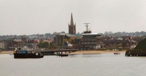
The Felixstowe area is primarily characterised as an industrial and settlement area, inexorably linked to the North Sea. The character area is situated between the Orwell and Deben Estuaries and incorporates the town of Felixstowe, the international Port of Felixstowe and industrial areas on the banks of the Deben Estuary. At the southern end of the character area the mouth of the River Orwell and the entrance to Harwich harbour are sheltered by the Languard peninsula. The town of Felixstowe has a population of c 29, 000 and is based along a strip of shingle beach with recreation facilities.
The Port of Felixstowe is the largest container port in the UK and the fifth largest in Europe. It has a number of terminals which handle goods including containers, bulk solids, grain, bulk liquids, forest products and Ro-Ro cargoes.
The seaside town is mainly notable for its shingle beach and pier. The latter was built in 1905 and was at one time the second longest in the country at 3/4 of a mile, until much of its length was demolished during the Second World War to prevent it being used as a landing point for enemy troops. The damage was never repaired and the pier was sadly neglected until the late 1990s, when it was deemed unsafe and closed to the public.
As a busy port, the offshore regions of the character area are within the jurisdiction of Harwich Haven Authority (HHA) and is covered by Vessel traffic services. It is subject to traffic separation and cautionary status due to submarine cables and high speed craft.
The depth of the offshore area around the coastal strip is generally no more than 2 m deep, though around the area of the docks the Harwich Deep Water Channel is dredged to 14.5 m. The tidal range in the character area is within the range of 3-4 m at Mean Spring Tide (DTI 2004).
Recreational sea fishing is common on Felixstowe beach, with a catch including Whiting, Cod, Sole, Bass and Garfish (http://www.leader-lines.com/). Recreational dive boats are launched from Felixstowe Ferry, heading up to 30 miles offshore, from Aldeburgh in the north to Kentish Knock in the south.
The Landguard peninsular is designated a SSSI on account of the number and quality of shingle-dwelling plant species by which it has been colonised, as well as its importance as a land-fall site for migrating birds.
The southern part of the docks area is currently the subject of proposals for redevelopment which will convert the area to provide additional deep water container capacity. The proposal will entail the dredging of a new approach channel and berths, and will include construction of a new railway terminal. It is intended that the development will largely be achieved by re-engineering existing operational areas, with minimal new impact, although it will involve the demolition of Admiralty oil tanks and seaplane erecting shed.
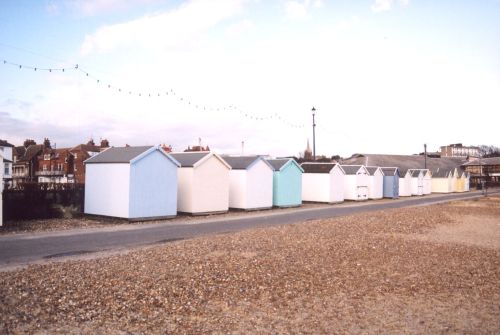
Caption: Beach huts at Felixstowe
Photo courtesy: Oxford Archaeology
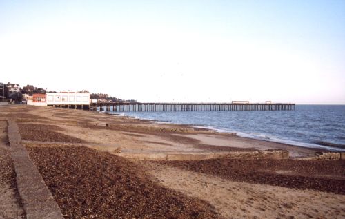
Caption: View of Felixstowe beach and pier
Photo courtesy: Oxford Archaeology
Historic Character and archaeological potential
Felixstowe is first recorded in the Domesday Book, but remained a small coastal village until developing into a major port in 1886. The town also developed a flourishing tourist industry during the late 19th century as the new fashion for sea bathing made the town a popular destination for visitors from London, facilitated by the opening of the railway station and pier in 1877. It became particularly fashionable following a visit by the German royal family, but declined by the late 1930s.
Archaeological finds in the character area include Neolithic flints, a Bronze Age burial with a cinerary urn and a Roman burial ground. The latter was discovered during coprolite extraction in the 19th century. Finds included a glass phial, tweezers, a mirror, gold rings, coins, tiles, bricks and pottery.
Felixstowe was home during the early part of the 20th century to the Seaplane Experimental Station, which was responsible for designing seaplanes and flying boats. In 1924 design work was discontinued and the station was renamed the Marine Aircraft Experimental Establishment, relocating to Helensburgh in Scotland during the Second World War.
A total of six wrecks are located within the offshore region of the character area including the possible remains of a British Destroyer sunk in 1939. On land five scheduled monuments include two Martello Towers (see link) and Landguard fort with associated fieldworks (see link). The coastguard station is a listed building. In addition a number of pillboxes, anti-tank cubes and anti-aircraft obstacles, a searchlight emplacement and Royal Observer Corps Monitoring post emphasis the importance of the area for coastal defence in the Second World War.
The archaeological potential of the area is high and includes the possibility of locating new shipwrecks. In addition the strategic importance of the area and its location in close proximity to two estuaries make it a hotspot for submerged prehistoric remains.
Character perceptions
The character area was late to develop any maritime significance, though its prominence in international trade has made Felixstowe a maritime giant over a short period of time. The town is still visited regularly by tourists who enjoy the seaside facilities. The presence of Landguard fort, a monument of national significance brings an element of historic importance and must be a key consideration in any redevelopment plans.
Bibliography
DTI, 2004, Mean Spring Tidal Range: Atlas of UK Marine Renewable Energy Resources. Department of Trade and Industry, 2004
Bawdsey Radar Group. Available at: http://www.bawdseyradargroup.co.uk/ (15/03/2007)
Leader Lines. Available at: http://www.leader-lines.com/ (07/03/2007)
Wikipedia. Available at: http://en.wikipedia.org (15/03/2007)
