
England's Historic Seascapes: Southwold to Clacton
Oxford Archaeology (South), 2007. https://doi.org/10.5284/1000277. How to cite using this DOI
Data copyright © Historic England unless otherwise stated
This work is licensed under the ADS Terms of Use and Access.


Primary contact
Oxford Archaeology (South)
Janus House
Osney Mead
Oxford
OX2 0ES
UK
Tel: 01865 263800
Fax: 01865 793496
Resource identifiers
- ADS Collection: 746
- ALSF Project Number: 4729
- DOI:https://doi.org/10.5284/1000277
- How to cite using this DOI
England's Historic Seascapes:
Southwold to Clacton
ALSF Project Number 4729
Oxford Archaeology, 2007
Harwich Area
Primary Subcharacter Type:
Coastal/estuarine settlement
Main Character / current form and use
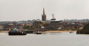
The Harwich area is primarily characterised as an industrial and settlement area, inexorably linked to the North Sea. The historic town is located on the extremity of a north facing peninsula which projects into Harwich Harbour. The two original settlements of Harwich and Dovercourt are now contiguous and referred to collectively as Harwich. The natural landscape at Harwich forms the finest natural harbour between the Humber and the Thames, at the confluence of the Stour and Orwell estuaries.
As well as a large town Harwich is currently characterised by the international port at Parkeston Quay on the Stour. Harwich International Port is one of the UK�s leading multi-purpose freight and passenger ports handling freight and passenger traffic to and from Scandinavia and the Low Countries (http://www.harwich.co.uk/). As such the traffic using this area is continuous and dense.
Harwich harbour is controlled by a wider agency known as Harwich Harbour Authority (HHA), the jurisdiction of which covers the ports of Felixstowe and Ipswich and has far reaching impacts into the offshore area. The harbour areas contained within the character area are subject to restrictions concerned with submarine cables and high speed craft and are covered by vessel traffic Services (VTS).
Much of the area of sea around the peninsula on which Harwich is located is within the area known as the shelf, the depth of which reaches up to 5 m. However, the Harwich Deep Water Channel, which leads into the port area is annually dredged to 14.5 m depth. The tidal range in the character area is within the range of 3-4 m at Mean Spring Tide (DTI 2004).
Secondary characteristics of the harbour area include recreational fishing which occurs off Halfpenny Pier and the Dovercourt area (http://www.leader-lines.com/). Recreational dive boats are launched from Harwich, heading up to 30 miles offshore, from Aldeburgh in the north to Kentish Knock in the south. A primary Royal Yacht Association (RYA) route crosses the area to the east of the Deep water Channel. The town itself is also a tourist destination.
The area has been extensively developed in recent years. Provisional approval was given in December 2005 for construction of the �300 million development of Bathside Bay which could make Harwich International the second largest container port in the UK, almost doubling quay length to 3000 m, potentially changing the character of the area.
Historic Character and archaeological potential
Harwich is very significant from a maritime historical perspective, in addition its archaeological potential is high and areas of deep stratigraphy and waterlogging have been located through excavation (Essex County Council Nd)
Prehistoric activity is recorded within the character area from the Palaeolithic onwards, particularly around Dovercourt, where in 1908 a large collection of tools and faunal remains were found in Gant Pit (Essex County Council Nd). Mesolithic tools have been found on Dovercourt beach and remnants of a Neolithic settlement, barrow cemeteries and Late Bronze Age axes and dwelling sites have been located within the Dovercourt region. No evidence of Iron Age occupation exists.
The Romans mined septaria stone from the cliffs and seabed around Dovercourt, and historic accounts and chance finds indicate the possible presence of Roman settlement and salt working sites. Finds include a tesselated pavement from Dovercourt.
The town appears under the name Duvrecurt in the Domesday Book of 1087 under the ownership of Aubrey de Vere (http://www.harwich.net/histbrf.htm) but did not obtain real significance until 13th Century when the town was developed as an economic venture by Roger Bigod, 4th Earl of Norfolk, in direct competition with the port of Ipswich. The town received its charter in 1238 and was granted a weekly market in 1253. By the14th century Harwich had become an assembly point for ships summoned by the king in times of war and by the 15th century had a flourishing ship-building industry (http://www.harwich.net/histbrf.htm).
During the 16th and 17th centuries Harwich gained significance as a defensive area as a result of successive wars with France, Spain and Holland and a naval dockyard was constructed in 1657 and remained in use until 1713. Cod fishing and the coal trade also became prominent and Harwich mariners led expeditions to Jamestown and New England including Christopher Jones who captained the Mayflower. The 17th century also saw the establishment of the packet boat service to Ipswich and London (http://www.harwich.net/histbrf.htm), run from the Halfpenny pier from 1853. In 1854 the railway came to Harwich and in 1883 Parkeston Quay was built increasing traffic to the Continent. The Continental Pier (Trinity) was built in 1886 (ibid).
The threat of invasion from France in the Napoleonic era led to the construction of the Redoubt (1808-1810) a circular fort, surrounded by a moat (see link). Other defences include the Martello tower (see link), Bath Side Battery and Angel Gate Battery, built in 1811. A battery was also constructed on Beacon Hill in the 1890s. Later Harwich was an important naval base in both world wars and witnessed the surrender of the German U-boats in WW1.
In the offshore region of the character area contains 25 wrecks including the possible remains of HMS Marsa lost to a mine in 1917 and therefore the potential for shipwreck archaeology is high. Onshore a number of scheduled monuments include the battery at Bath Side Bay, the Beacon Hill Fort, the Redoubt (see link), the High and Low lighthouses and the Dovercourt lighthouses (see link). The remains of a treadmill crane constructed in 1667 is situated on the eastern shore of the peninsula, housed in a rectangular structure. Other monuments include Parkeston Quay, built in 1883 and still in use within the modern port. A number of WW2 monuments survive including pillboxes and an extended defence officers post, the Royal Naval base, four spigot mortar positions and a single anti-tank cube block, a battery of twin gun emplacements and a Radio Direction Finding Tower. Overall there are 206 listed buildings within the character area.
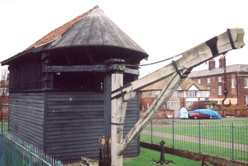
Caption: Harwich navalyard treadmill crane
Photo courtesy: Oxford Archaeology
Character perceptions
Harwich is one of the most important maritime centres in England. It has a rich maritime history stretching back into the Middle Ages and may have been a coastal settlement as far back as Prehistory. The town plan has barely changed since the Medieval period.
Henry VIII based his navy in Harwich and Elizabeth I was said to have commented that Harwich was a "pretty little town and wants nothing" (Wheatley 1990, 57). Maritime links include tales of Nelson and Lady Hamilton who were said to frequent the Three Cups (Hay and Hay 1972).
The area is crucial to the region in terms of its economic, historic and tourism values. This is set to be altered by the Bath Side Bay development, though it is not likely to dramatically change the character of the area.
Bibliography
DTI, 2004, Mean Spring Tidal Range: Atlas of UK Marine Renewable Energy Resources. Department of Trade and Industry, 2004
Essex County Council, Nd, Harwich Town Assessment Report. Essex Extensive Urban Survey. Essex County Council
Hay, D. & Hay, J. 1972, East Anglia from the Sea. E Stanford
Wheatley, K., 1990, National Maritime Museum Guide to Maritime Britain. Webb & Bower
Harwich History: A brief History of Harwich. Available at: http://www.harwich.net/histbrf.htm (15/03/2007)
Harwich International Port. Available at: http://www.harwich.co.uk/ (15/03/2007)
Leader Lines. Available at: http://www.leader-lines.com/ (07/03/2007)
Wikipedia. Available at: http://en.wikipedia.org (15/03/2007)
