
England's Historic Seascapes: Southwold to Clacton
Oxford Archaeology (South), 2007. https://doi.org/10.5284/1000277. How to cite using this DOI
Data copyright © Historic England unless otherwise stated
This work is licensed under the ADS Terms of Use and Access.


Primary contact
Oxford Archaeology (South)
Janus House
Osney Mead
Oxford
OX2 0ES
UK
Tel: 01865 263800
Fax: 01865 793496
Resource identifiers
- ADS Collection: 746
- ALSF Project Number: 4729
- DOI:https://doi.org/10.5284/1000277
- How to cite using this DOI
England's Historic Seascapes:
Southwold to Clacton
ALSF Project Number 4729
Oxford Archaeology, 2007
The Naze
- The Naze
- Beaumont Quay
- Hamford Water / Blackford Backwaters
- The Naze Cliffs
- The Naze Tower
- The North Sea Flood of 1953
Primary Subcharacter Type:
Protected Area
Main Character / current form and use
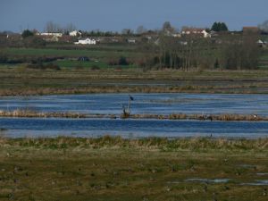
The Naze is located in the south of the study area, on the Essex side of the Suffolk/Essex border. The majority of the character area comprises the low-lying areas known as Hamford Water and Walton Backwaters. This is a large, shallow, estuarine basin comprising over 2000 hectares of tidal creeks and islands, saline lagoons, intertidal mudflats, sandflats and saltmarsh, backed to the south by Early Pleistocene Red Crag cliffs, up to 15 m high. The area also includes the Naze foreshore and public open space, containing the John Weston nature reserve. It is characterised today by its status as an internationally recognised area for wildlife and fossils. Walton Backwaters is a RAMSAR site, Hamford Water is a Special Protection Area (SPA) and the cliffs and foreshore are included within an SSSI as a result of the land and sea fossils exposed within the cliff face. Offshore the area also incorporates Pennyhole Bay, a shallow sea area and secluded beach.
The basin is located within the larger estuarine system of the Stour/Orwell and environment and character is dominated by these estuaries (English Nature 2002). Localised longshore drift along the open coast moves sediment north from the Naze to form a spit of land with Stone Point at its northern tip, extending to Pye Sands. This system restricts the width of the channel and is overtopped at high tide allowing extensive salt marshes to develop on either side (ibid). As a result the area supports unusual assemblages of invertebrates and plants, different to those of the adjacent estuaries or open sea. The area is probably most significant as a refuge for birds, and is accordingly designated an SPA. Horsey Island is the largest of the islands and supports a colony of over 70 harbour seals and grey seals; Skippers Island is a protected bird sanctuary.
The underlying geology has had an important influence on the character of the area. This comprises Eocene rocks, overlain by a London Clay, a sequence of Quaternary sands and gravels, Holocene sands and muds. Much of the sand today is created through erosion of the Red Crag cliffs which is also threatening the area.
Historic Character and archaeological potential
The Naze once formed thenorthern side of the major river valley which contained the Thames, Medway, Crouch, Colne and Blackwater and their minor tributaries before rising sea levels drowned them c. 8000 years ago (D'Olier 2002). This setting, close to the coastline and major estuaries high in marine resources, suggests the Naze was a prime location for early human settlement.
The majority of archaeological material from this area was found at Stone Point, possibly representing a palaeo land surface broken up by the sea (Wilkinson and Murphy 1995). The assemblage included a tanged point which may place settlement in the area as early as the Upper Palaeolithic (Jacobi 1980). The Mesolithic was represented at Stone Point by a significant assemblage of microliths which may indicate that some of the Mesolithic activity in the area took place when the main part of the major Mesolithic sea level rise had taken place and the coast had reached its present outline (with the exception of coastal erosion). The discovery of Neolithic pottery and axeheads may indicate that settlement was continuous.
Notably the character area lies within a section of the coastline in which a buried land surface outcrops, termed the 'Lyonesse surface,' by S. Hazzledine Warren in the early 20th century. Today the surface is depleted due to coastal erosion and development, though patches are present at the Walton end of the Naze. Evidence suggests the surface was inundated in the Neolithic period, shortly after 3800-3700 BP (Wilkinson and Murphy 1995, 101). Warren located Beaker sites, pits and flint scatters indicating continuity of settlement from early to late Neolithic. It is probable that Prehistoric settlers exploited the landscape using craft such as logboats, an example of which was seen at Walton strand in 1936.
Settlement appears to be discontinued in this area of the coast after the Prehistoric period, though Red Hills were also found at Stone Point/ Walton.
The headland is characterised by The Naze Tower, constructed by Trinity House on the Naze cliffs in 1721 (see link). The headland surrounding the Naze Tower was originally privately owned land and became a golf course in 1928. In 1963 the land was bought by local authorities and remains a public open area.
In the 19th century the western area of the Naze, inland from Walton was a centre for busy coastal trade. This is represented by Beaumont Quay (see link). Victorian sea defences were constructed in order to try and save the area from further erosion, including the 'Tamarisk Wall.' During World War II the area was mined and access restricted and the sea defences fell into disrepair and were almost completely destroyed by the 1953 storm (see link) surge.
In total, 26 wrecks are recorded within the character area, though most of these were deliberately scuppered by the National Rivers Authority to protect Horsey Island. The coastal strip also contains 19 listed buildings and a number of pill boxes and 20th century defences. Three scheduled monuments include two WWII bombing decoys at Kirby-le-Soken and a post-medieval duck decoy pond situated at the western end of Horsey Island.
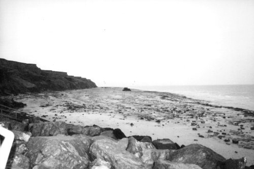
Caption: View from the beach of the eroded Naze headland
Photo courtesy:Oxford Archaeology
Character perceptions
The character area is important to the region in terms of its natural significance and as a visitor attraction. Its importance is illustrated by formation of The Naze Protection Society, a local group which works towards finding a solution to the ongoing erosion problems with local and central authorities. The site is also internationally renowned for its wildlife.
The Hamford Water / Walton Backwaters area is well known as the setting for Arthur Ransome's novel 'Secret Water', the eighth book of the Swallows and Amazons children's series, published in 1939. In addition the area was once home to William Witney Gull who became Queen Victoria's personal physician and is rumoured to have been Jack the Ripper. His house still remains standing at Landermere Quay.
In combination with its function as a natural attraction, the Naze is very popular for recreational sailing and a number of marinas have been constructed within Walton Backwaters. The sandbank areas around Pye Sand and Crabknowe Spit can be very shallow at low water and act as a hazard to small boats, additionally two dangerous wrecks are recorded.
Bibliography
D'Olier B (2002)'A geological background to sediment sources, pathways and sinks' in Southern North Sea sediment transport study. Phase 2. H R Wallingford, CEFAS/UEA, Posford Haskoning and Dr Brian D'Olier.
English Nature, 1997 Greater Thames Estuary Coastal Natural Area Profile. Technical Report. Colchester
English Nature, 2002 Essex Coast and Estuaries Coastal Habitat Management Plan (CHaMP) Final Report.
Gray, J.M. 1988 Coastal cliff retreat at Walton on the Naze, Essex since 1874: patterns, rates and processes. Proc. Geol. Ass. 99(4) 335- 338.
Jacobi R. M., 1980 'Late-glacial settlement in Essex' in Buckley D.G. (ed.), Archaeology in Essex to AD 1500, Counc. Brit. Archaeol. Res. Rep. 34, 12-13
Wilkinson, T.J. and Murphy, P.L, 1995 Archaeology of the Essex coast, Volume 1: the Hullbridge Survey, East Anglian Archaeology 71, Chelmsford
imnh.isu.edu/digitalatlas/glossary/letter.asp
Wikipedia. Available at: http://en.wikipedia.org (15/03/2007)
