
England's Historic Seascapes: Southwold to Clacton
Oxford Archaeology (South), 2007. https://doi.org/10.5284/1000277. How to cite using this DOI
Data copyright © Historic England unless otherwise stated
This work is licensed under the ADS Terms of Use and Access.


Primary contact
Oxford Archaeology (South)
Janus House
Osney Mead
Oxford
OX2 0ES
UK
Tel: 01865 263800
Fax: 01865 793496
Resource identifiers
- ADS Collection: 746
- ALSF Project Number: 4729
- DOI:https://doi.org/10.5284/1000277
- How to cite using this DOI
England's Historic Seascapes:
Southwold to Clacton
ALSF Project Number 4729
Oxford Archaeology, 2007
Rough Shoals
HM Fort Roughs / Sealand
One of the most notable features of this character area is the presence of HM Fort Roughs or the Roughs Tower, constructed on the Rough Shoals sandbank. The tower is one of four similar structures designed by G A Maunsell and placed in the North Sea during WW2 to protect London and the coastal areas such as Harwich from enemy aircraft and shipping attacks. The forts were intended to act as an early warning system, break up aircraft formations and prevent minelaying. This was particularly crucial as the Luftwaffe were dropping a new German Magnetic Influence Mine by parachute from seaplanes resulting in heavy shipping losses (http://www.bobleroi.co.uk). Each fort had a steel gun platform with two anti-aircraft guns, a control tower and radar equipment (http://www.offshoreechoes.com). The platform of the forts were supported by two 8m diameter concrete legs on a pontoon base, each of which contained seven floors comprising living quarters and storage areas. The forts adopted the MOD code Uncle with each given the abbreviation U. The Rough Shoals fort was known as U1. The forts were abandoned in 1956 and many were discovered by pirate radio stations in the 1960s.
Presently the fort is occupied by the family of Paddy Roy Bates, a former radio broadcaster and British Army major who took the fort by force in 1967. The Royal Navy tried to forcibly evict Bates at this time but were repelled by warning shots. As the fort was outside territorial waters at the time a court ruled in Bates' favour. Although the fort has no legal status the family claim it is an independent state of 'Sealand'. Following this he introduced a flag, constitution, currency and passports (http://en.wikipedia.org/wiki/Sealand). The fort is currently available for transfer of ownership, therefore its future is uncertain.
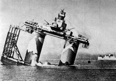
Caption: Grounding of Rough Tower in 1942
Photo courtesy: Offshore Echoes
