
England's Historic Seascapes: Southwold to Clacton
Oxford Archaeology (South), 2007. https://doi.org/10.5284/1000277. How to cite using this DOI
Data copyright © Historic England unless otherwise stated
This work is licensed under the ADS Terms of Use and Access.


Primary contact
Oxford Archaeology (South)
Janus House
Osney Mead
Oxford
OX2 0ES
UK
Tel: 01865 263800
Fax: 01865 793496
Resource identifiers
- ADS Collection: 746
- ALSF Project Number: 4729
- DOI:https://doi.org/10.5284/1000277
- How to cite using this DOI
England's Historic Seascapes:
Southwold to Clacton
ALSF Project Number 4729
Oxford Archaeology, 2007
Shipwash Dredging
Primary Subcharacter Type:
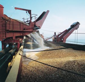
Dredging (aggregates)
Main Character / current form and use
This character area encompasses a tract of open sea, approximately 15 km x 12 km, to the east of the Shipwash Bank, off the coast of Orford. The area is predominantly characterised as a busy shipping route. It is also defined by its history of aggregates dredging.
The area is transited by bulk carriers, cargo ships, tanker, ferries and gas carriers (Jones et al nd) and is heavily used as the main route from Black Deep (see Black Deep and Long Sand character area) and consequently the Thames estuary. Recent surveys showed that 16,862 vessels transited the area to the south of this region (UKHO 2006), most of which will have used this area. Incoming vessels were funnelled into the Sunk Precautionary Area and Harwich Deep Water Channel was used outbound into the open sea. As a result of its proximity to the ports of Harwich and Felixstowe the area comes within the jurisdiction of the Harwich regulatory system. It is subject to restrictions concerned with high speed craft, submarine cables and traffic separation and is covered by Vessel Traffic Services (VTS).
A series of Royal Yacht Association routes cross the west of the area, heading into Orford Haven and along the coast. The area is also a potential recreational dive site.
The character area is mostly within the depth range of 20 m to 30 m, although some areas are deeper, up to 50 m and in the northwest corner the depth decreases to 15-20 m. The tidal range in the character area is within the range of 2-4 m at Mean Spring Tide (DTI 2004). The sediment in the area is mainly coarse sand and gravel, with large areas of gravel, making it viable for aggregates dredging. This type of activity has taken place over much of the area, though not all the licensed area is still in use. Companies known to have been connected with this area include United Marine Dredging, East Coast Aggregates, South Coast shipping, ARC Marine, Hanson Civil and Marine, British Dredging Ltd and Cemex UK (Marine). Dredging activity is related to market demand, therefore activity can be sporadic and difficult to predict (Rogers 1997). This affects fishing activity as actively dredged areas are temporarily closed to commercial fishing. Recently sand dredged from the Shipwash area has been used for coastal defences on Southwold Beach.
Historic Character and archaeological potential
Little is known about the historic character of this area, which is not named or emphasised on available historic charts. However, the area contains 31 known wrecks, 23 of which are considered dangerous. The majority of the named wrecks were known to have been mined. Losses include a number of coastal vessels carrying cargo such as coal, including the Polgarth, Lonhelen, Forth, Moidart, Wychwood, Coalgas and Old Charlton. Continental trade is represented by the Rym, Estrella and Warrenpoint. Overall this demonstrates the importance of the character area to both coastal and continental vessels and its role in the defence of Britain. The potential for shipwreck archaeology is high.
The Albert Close fishing chart of 1953 records that this area was good sole ground in the summer.
In addition the area has potential to contain submerged prehistoric landscapes, features or artefacts, having been dry land prior to 8000 BP. However, no investigation work is known to have been done in this area.
Character perceptions
The Shipwash dredging area is generally perceived as an industrial area, both for shipping and aggregate dredging. It is not an area likely to be known by local populations but is a clearly recognised channel into the deep sea from the Haven ports and London.
Bibliography
DTI, 2004, Mean Spring Tidal Range: Atlas of UK Marine Renewable Energy Resources. Department of Trade and Industry, 2004
Jones, L. A., Coyle, M. D., Evans, D., Gilliland, P.M., & Murray, A. R., Southern North Sea Marine Natural Area Profile: A contribution to regional planning and management of the seas around England. Peterborough: English Nature.
Rogers, S. I., 1997, A review of closed areas in the United Kingdom Exclusive Economic Zone. CEFAS Science Series Technical Report No. 106
UKHO, 1953, Close�s Fishermen�s Chart of the North Sea United Kingdom Hydrographic Office
UKHO, March 2006, Thames Estuary South Ship Head: Assessment on the Analysis of Routine Resurvey Area TE3 from the 2005 Survey. UKHO
Wikipedia. Available at: http://en.wikipedia.org/wiki/Main_Page (07/03/2007)
