
Glastonbury Abbey: Archaeological Excavations 1904 - 1979
University of Reading, Trustees of Glastonbury Abbey, 2015. https://doi.org/10.5284/1022585. How to cite using this DOI
Data copyright © The Glastonbury Abbey Archaeological Archive Project unless otherwise stated
This work is licensed under the ADS Terms of Use and Access.

Primary contact
Prof
Roberta
Gilchrist
Department of Archaeology
University of Reading
Whiteknights
PO Box 218
Reading
RG6 6AA
England
Tel: 0118 9318132
Resource identifiers
- ADS Collection: 1447
- DOI:https://doi.org/10.5284/1022585
- How to cite using this DOI


Overview
Summary of findings
Reassessment of the archive has revealed new evidence for occupation pre-dating the first Christian settlement at Glastonbury, including material culture dating from the Iron Age to Roman and post-Roman periods, and a timber structure and trodden floor associated with imported late Roman amphorae (dated c450-550). Excavations in the 1920s revealed three phases of a Saxon stone church with detached burial crypt to the east; the crypt was incorporated into the church in the second phase and a tower was built over it in the third phase. Glastonbury exhibits the axial layout of churches that is characteristic of Anglo-Saxon monasteries. From the seventh to eighth century, there were three churches on the same alignment: the vetusta ecclesia, and to the east, the church of St Peter and St Paul and the detached crypt. The dating of five Saxon glass furnaces has been reassessed in conjunction with Bayesian analysis of radiocarbon dates from wood charcoal samples: the glass-making is likely to represent a single episode of production in the late seventh or early eighth century, connected with construction of the first stone church on the site. Compositional analysis of the Saxon glass and associated metalworking debris has confirmed that glass-working at Glastonbury incorporated recycled Roman materials. Several details of Radford's interpretation of the early monastery are challenged by reassessment of the archive, including the existence of a pre-Christian 'British' cemetery and the discovery of Arthur's grave. There were freestanding stone buildings to the south of the church at Glastonbury in the late Saxon period but there is no evidence for Radford's late Saxon cloister, an assertion that has been widely accepted as confirmation of the influence of Dunstan and the importance of Glastonbury in reforming the character of English monasticism in the tenth century.
Radford's interim reports provide very little detail for the Norman and later medieval monastery. Re-examination of the records has confirmed stratified evidence for the Norman and later medieval monastic ranges and revealed the sequence for the replacement of the Saxon and Norman buildings. There was substantial reconstruction of the church and claustral buildings after a devastating fire in 1184. It is estimated that the Great Church was largely complete and roofed by c1230. Major rebuilding took place in the fourteenth century, with John of Taunton beginning construction at the west end (1274-1301) and Walter of Monington remodelling the east end (1342-75). Glastonbury is highly unusual in the apparent absence of a west range to the monastic cloister, perhaps resulting from the evolution of the abbot's range in the south-western corner of the inner court. The excavated evidence confirms that the abbot's hall complex was completely remodelled from the early fourteenth century, providing a spacious and luxurious court c70m square for the abbot and his guests. The new complex comprised a grand hall and porch which provided a waiting room for visitors, accommodation for the abbot and his guests, a chapel, kitchen and service range and walled garden. Evidence for the Dissolution includes salvage activities and stone-breaking; post-medieval occupation in the precinct is represented by high status material culture associated with the use of the former abbot's lodging as a mansion up to the seventeenth century.
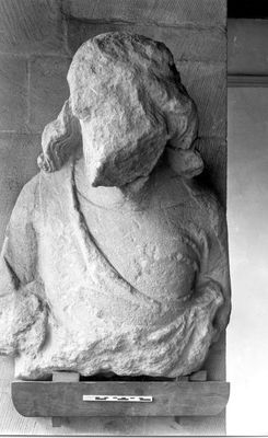
The monastic character of the medieval finds assemblage is evidenced especially in the objects linked with music and literacy and the large number of items for personal devotion that were owned by monks or secular guests and pilgrims. The assemblage of 7000 ceramic tiles represents a wide range of motifs and chemical analysis of the clay used in the fabric shows the majority were made at kilns close to Glastonbury. The assemblage of over 2000 fragments of medieval stained glass includes durable blue glass, confirmed by compositional analysis to have a mixed soda potash composition. It is likely to date to the twelfth century and confirms that Glastonbury's early glazing schemes were of the highest quality, comparing favourably with York, Winchester, Chartres and Saint-Denis. Study of the worked stone assemblage reveals the lavish cloister constructed by Abbot Henry of Blois, c1150: the fifty-one fragments of blue lias carving are amongst the finest examples of Romanesque sculpture produced in England. The assemblage of nearly 1500 fragments of Gothic sculpture confirms large-scale building activity following the fire of 1184, with major work undertaken from the 1180s into the 1250s. There are some stylistic affinities with Wells and the figural carvings from the north transept and Galilee demonstrate the outstanding quality of the Early English abbey church. There are many conservative or retrospective elements evident in the medieval architecture of Glastonbury Abbey; this tendency seems to have been deliberate and strategic, aimed at demonstrating the antiquity of Glastonbury and its pre-eminent place in monastic history.
Reassessment of the archive of excavations has identified a number of new questions for future research. The presence of LRA1 pottery confirms occupation at Glastonbury in the fifth or sixth century, but there is no evidence yet to suggest whether this was a religious community, or a high status secular settlement engaged in long-distance trade. The relationship of the monastery to earlier settlement patterns deserves further consideration; for example, it is possible that the monastic vallum incorporates a defensive bank and ditch pre-dating the monastery. A striking feature of the finds assemblage is the lack of evidence for metal objects dating to the middle and late Saxon periods. The paucity of evidence dating from the seventh to the ninth centuries prompts the question of whether the early monastic core has actually been located. It is feasible that the main domestic buildings of the Middle Saxon monastery were situated to the north of the church, in an area yet to be examined. Fresh excavations will be required to fully understand the character, form and dating of the Saxon monastery at Glastonbury.
Methodology including use of IADB
The pilot project 2007-8
The EH archive was catalogued and accessioned during the 2007-8 pilot project and subsequently re-ordered by EH. Primary excavation records were either scanned to create digital safety copies or transcribed. Secondary sources such as personal correspondence and newspaper cuttings were more variable in their archaeological content and notes were therefore only taken where relevant.
A test area was written-up in order to evaluate the quality of Radford's records and to develop an appropriate methodology for a full-project: the chapter house area was selected for this purpose. This area had also been partially excavated by Bond in 1910 and by Wedlake in 1935; it therefore provided a suitable test for amalgamating the excavation records from different campaigns. A geophysical survey carried out by the University of Reading proved essential to the successful outcome of this trial project. It was also concluded that an archaeological database would be required to process and integrate the records for the full archive. The Integrated Archaeological Database (IADB) created by Mike Rains (York Archaeological Trust) has been specifically designed to manage the data from large-scale archaeological projects.
A team of specialists was assembled in order to carry out the multitude of tasks that would be required for a full project covering the 20th century antiquarian excavations.
The archive project 2009-2013
The excavations
A list of all the excavation areas and trenches is provided for each period:
- 1908-39 excavation trenches
- Radford's excavation trenches
- Wedlake's excavation trenches
These lists provide the original trench names where present but also provide cross-referencing to any new trench numbering systems, new context numbers and photographic references that may have been created within the IADB. New numbering was not applied to the 1908-1939 excavations as much of the work involved clearance. However, the list includes publication references and details of the findings where this is not discussed elsewhere.
Mapping
The base mapping was taken from a recent survey of the precinct by Downland Partnership and tied into the Ordnance Survey National Grid, providing the necessary spatial framework for the archaeology. Most of the trenches were plotted from measurements on original plans, either triangulated from fixed points (usually upstanding remains) or base lines. Setting-out diagrams contained within Radford's site notebooks were useful for locating or confirming the locations of trenches.
Radford stated that the locations of the trenches from excavations pre-dating 1950 were generally too vague to facilitate cartographical delineation; overall this was found not to be true. The locations of most of the trenches mentioned in antiquarian publications and in the excavation notes have now been established, although an approximate position was only possible for some (see trenches with dashed lines in the Monograph). Published plans were also useful for confirming the locations of the pre-Radford trenches, although they did not always correspond exactly with the original plans. There were also discrepancies between the plans drawn of identical areas in different years, partly resulting from deterioration of exposed masonry between seasons. Where applicable, we have relied on the earliest plans of any exposed masonry. Problems were also generated by an inherited planning error from 1913, which assumed the cloister was an exact rectangle, which was not identified until 1952 (see Monograph for full discussion). As a result, Radford noted that some buildings discovered by excavation could no longer be plotted. Challenges were also caused by difficulties in deciphering hand-writing and various discrepancies in the records. Both the geophysics results and the photographic record were crucial in overcoming these difficulties.
A high success rate has been achieved in mapping Radford's 103 trenches and four test-holes. Most of these trenches have been precisely located with confirmation provided by excavation photographs and the geophysical data, which provided ground truth for several trench locations and for features recorded within trenches. The mapping of Wedlake's 1978-79 excavation plans was fairly straightforward. However, where drawings had been amalgamated from earlier excavations, the tracings resulted in human error on the base maps, propagating the pre-1950s survey errors mentioned above. The plentiful excavation photographs were extremely useful in clarifying trench locations.
In practical terms, there was some distortion of the original plans and sections drawings, in particular those drafted on brown paper which tends to distort with age. Brown paper was a product of the economic climate of the early 1950s, when paper rationing was still in force. With the drawings now scanned and digitally stored as vector images any distortion has been minimized. In order to amalgamate the plans it was necessary to standardize the variety of planning scales that had been used throughout the antiquarian excavations and to transfer measurements from imperial to metric. The new master plan of the site has been digitally created at 1:50, and sections drawn at 1:20. Many of the plans and sections from Radford's excavations include levels, some of which have been reduced; however, the Newlyn datum level has changed over the course of the century and the site has been landscaped. Consequently, it was considered that length of time it would have taken to convert the levels from imperial to metric and to reduce was not worthwhile.
The database
The IADB was specifically adapted for the Glastonbury Abbey project for the post-excavation analysis of antiquarian excavation records and to process section drawings (as opposed to single-context plans).
Using the IADB, the primary field records were tagged by year and trench name to link evidence with specific trenches where possible. All ninety section drawings were digitized within the IADB and assigned context numbers, which were also applied to the master plan created outside of the IADB. The majority of the excavation photographs only retained a date and it was necessary to link the photographic material to the trenches and where possible to features. Information from the excavation notes and other written evidence was transferred to the context records to retain source information.
Approximately 5050 finds retained contextual information with potential to link them with archaeological deposits, or at the very least, the year of excavation and trench or area from which the find was recovered. With some finds from the same context, a total of c 1530 finds records were created within the IADB. For Radford's excavations, context information had been recorded on brown envelopes detailing distance from one end of the trench and depth from the trench surface, often supplemented with a context description. As a result, it has been possible to link 2400 finds to archaeological deposits, albeit with differing degrees of certainty. The new specialist finds assessments have provided a limited dating framework allowing the archaeological phasing and stratigraphy to be properly assessed. All contexts have been included on stratigraphic matrices approximately arranged by phase and divided into ten areas; however, it was not possible to deduce relationships for all contexts.
Full excavation reports were written within the IADB. The Background and Results sections are reproduced within this archive. The Results provide a technical stratigraphic account based on the sections, plans, photographic material, sketches and notes for each trench. The phased Discussion sections (which form the basis of Chapters 4-6 in the Monograph) provide a critical appraisal of the archaeology incorporating new dating and spatial evidence from specialist finds reports, the recent geophysical survey, the parchmark and earthwork surveys (Hollinrake and Hollinrake, 1989). Interpretations recorded in original records and publications have been re-evaluated and features have been attributed to the earliest possible phase.
Acknowledgements
The project was funded by the Arts and Humanities Research Council (2009-12); the pilot project was funded by the British Academy (2007-8). Additional funding was provided by Linda Witherill, the University of Reading, the Society for Medieval Archaeology and the Maltwood Fund of the Somerset Archaeology and Natural History Society. We are also grateful to the English Heritage Archive (formerly National Monuments Record) for access to the archive of C A R Radford, to the Ordnance Survey for permission to use base maps and to Downside Abbey and the Glastonbury Antiquarian Society for permission to reproduce illustrations.
We would like to thank past and present staff and trustees of Glastonbury Abbey: John Allan, Janet Bell, Matthew Clements, Vicky Dawson, Robert Dunning, Mary Gryspeerdt, Francis Thyer and Peter Saunders. Thanks are also made to the many enthusiastic volunteers at Glastonbury Abbey: Caroline Bacon, Lindsay Beech, James Budden, Sarah Chard, Mary Claridge, Nadia Davies, Doug Forbes, Jenny Fowler, Feona Green, Susan Paisley, Lindsey Paton, Margaret Poyntz-Wright, Peter Poyntz-Wright, Christine Robertson, Frances Taylor, Julie Taylor and Pamela Walker.
We would also like to acknowledge: Rosemary Cramp, Ian Freestone, Dan Gardner, Tony Harcourt, Charles and Nancy Hollinrake, Lisa French, Marek Lewcun, Paul Pettitt, Nicky Powell, Gabor Thomas, Barney Sloane, Rhi Smith, Context One Archaeological Services, Museum of London Archaeology, the School of Archaeology, Geography and Environmental Science at the University of Reading, the Society of Antiquaries of London and the Somerset Heritage Centre.
Special acknowledgement is due to Philip Rahtz (d. 2011) and Lorna Watts, who supported the project from its inception and generously shared their knowledge of the archaeology of Glastonbury and its environs.
