Land adjacent to Ashton House, High Street, Ongar, Essex. Archaeological Evaluation (OASIS ID: heritage1-275538)

The Heritage Network, 2018. https://doi.org/10.5284/1048327. How to cite using this DOI

Digital Object Identifiers

Digital Object Identifiers (DOIs) are persistent identifiers which can be used to consistently and accurately reference digital objects and/or content. The DOIs provide a way for the ADS resources to be cited in a similar fashion to traditional scholarly materials. More information on DOIs at the ADS can be found on our help page.

Citing this DOI

The updated Crossref DOI Display guidelines recommend that DOIs should be displayed in the following format:

https://doi.org/10.5284/1048327
Sample Citation for this DOI

The Heritage Network (2018) Land adjacent to Ashton House, High Street, Ongar, Essex. Archaeological Evaluation (OASIS ID: heritage1-275538) [data-set]. York: Archaeology Data Service [distributor] https://doi.org/10.5284/1048327

Data copyright © The Heritage Network unless otherwise stated

This work is licensed under the ADS Terms of Use and Access.
Creative Commons License


The Heritage Network logo

Primary contact

The Heritage Network
11 Furmston Court
Icknield Way
Letchworth
SG6 1UJ

Send e-mail enquiry

Resource identifiers

Digital Object Identifiers

Digital Object Identifiers (DOIs) are persistent identifiers which can be used to consistently and accurately reference digital objects and/or content. The DOIs provide a way for the ADS resources to be cited in a similar fashion to traditional scholarly materials. More information on DOIs at the ADS can be found on our help page.

Citing this DOI

The updated Crossref DOI Display guidelines recommend that DOIs should be displayed in the following format:

https://doi.org/10.5284/1048327
Sample Citation for this DOI

The Heritage Network (2018) Land adjacent to Ashton House, High Street, Ongar, Essex. Archaeological Evaluation (OASIS ID: heritage1-275538) [data-set]. York: Archaeology Data Service [distributor] https://doi.org/10.5284/1048327

Introduction

Land adjacent to Ashton House, High Street, Ongar, Essex. Archaeological Evaluation (OASIS ID: heritage1-275538)

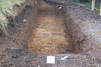
In order to characterise the archaeological potential of land adjacent to Ashton House, High Street, Ongar, Essex, the Heritage Network was commissioned by the developers to undertake an archaeological field evaluation. This work was a requirement of the planning consent granted by the local planning authority. An L-shaped trench was excavated across the footprint of the proposed building, revealing an earlier soil horizon below a considerable depth of overburden. Late post-medieval and modern features and services were also exposed within the trial trench.

No features deposits or finds of archaeological significance were encountered during the course of the present project and it appears that the line of the town's defensive ditch runs further to the north-west. On the basis of the results of the evaluation, the risk that the proposed development might disturb significant archaeological remains may be considered to be Low for all periods.


ADS logo
Data Org logo
University of York logo