
Troodos Archaeological and Environmental Survey Project
Michael Given, Vasiliki Kassianidou, A Bernard Knapp, Jay Noller, Luke Sollars, Hugh Corley, 2007. https://doi.org/10.5284/1000271. How to cite using this DOI
Data copyright © Dr Michael Given, Hugh Corley, Dr Luke Sollars unless otherwise stated
This work is licensed under the ADS Terms of Use and Access.


Primary contact
Dr
Michael
Given
Department of Archaeology
University of Glasgow
The Gregory Building
Lilybank Gardens
Glasgow
G12 8QQ
Scotland
Tel: 0141 3305690
Resource identifiers
- ADS Collection: 467
- DOI:https://doi.org/10.5284/1000271
- How to cite using this DOI


Overview
Methods
Within our 164km2 survey area we carried out fieldwalking transects in six intensive survey zones totalling 32km2. These were chosen to give a representative range of the topographic, environmental and cultural variation across the survey area. The rest of the area was sampled by means of a grid of 20 short transects and more purposive survey.
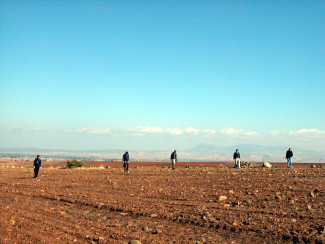
Transects are lines of survey units, traversed by fieldwalkers placed 5m apart. Where there were broad areas with high densities of artefacts and other features of interest, we also carried out contiguous block survey. These areas we termed Special Interest Areas (SIA, with identification numbers prefaced 'TS'). A particularly useful function of these was to allow us to investigate a settlement and its context as a single analytical entity. These methods were intended to give us a continuous view of human activity across the landscape, rather than limiting our analysis to a series 'sites' or dots on the map.
A typical survey unit (SU) is 25m across and between 50 and 100m long. It was surveyed by a field team consisting of four or five fieldwalkers 5m apart. The walkers counted sherds, tiles, chipped stone, ground stone, slag, shotgun cartridges and other artefacts, recorded relevant features such as ground visibility, and make a representative collection of the sherds. This was done by each fieldwalker collecting one of every type of sherd, as distinguished in the field: one thin sigillata rim; one thick sigillata rim; one thick sigillata base; etc. By the end of the project we had collected 30.1% of the 99,676 sherds found in 1119 survey units.
Each survey unit sits within a geomorphological unit (GU), which describes environmental features such as soil type, slope and surface stability. No survey unit can cross the boundaries of a geomorphological unit, which gives it analytical consistency and integrity.
The collected artefacts were analysed and recorded by the artefact team. Once the data entry and digitising had been done, the database tables could be joined to the GIS to produce artefact distribution maps. Clearly, we had to assess the reliability of these density figures. A series of seeding experiments run by Robert Schon in 2003 showed that varying ground density and artefact distribution had a surprisingly low effect on sherd recovery rates. Fieldwalkers were apparently compensating for poor conditions by scanning the ground more carefully. On this basis we decided not to factor the visibility and background ratings into our density analyses.
With the pottery distribution maps, we were able to exploit our representative collection procedures. This involved combining the total figures for sherds counted with the proportion of sherds collected of a particular characteristic (e.g. Roman, or cooking ware). This resulted in an estimated number of sherds of that characteristic in the entire survey unit, not just the 30% that we collected. These figures were then divided by the square area of the unit, to give estimated densities of sherds per 10 x 10m square (expressed as 'sherds per 100m2').
There were, of course, very clear focuses of human activity, many of them equivalent to the 'sites' of less intensive projects. These we termed Places of Special Interest (POSI, with identification numbers prefaced 'TP'). This is purely an administrative definition and carries no inherent cultural assumptions about meaning or function. Depending on their character, POSIs were variously recorded, mapped, gridded and sampled.
Our team also investigated a range of other disciplinary areas:
- archaeometallurgy (mainly by drawing and sampling sections of slag heaps)
- architecture (recorded systematically as 'Building Units')
- water distribution systems (by architectural recording, mapping and interviews)
- botany and geobotany (classifying satellite imagery; investigating olives and fuel sources)
- communication routes (including systematic recording of paths)
- oral history (by means of a series of recorded and transcribed interviews)
- documentary history
Dissemination (as of March 2007)
Given, M., Corley, H. and Sollars, L. 2007 'Joining the dots: continuous survey, routine practice and the intepretation of a Cypriot landscape (with interactive GIS and integrated data archive)', Internet Archaeology 20.
Jacobsen, K.W. 2004 'Regional distribution of transport amphorae in Cyprus in the Late Roman period.' In Transport amphorae and trade in the Eastern Mediterranean: International Colloquium at the Danish Institute at Athens, 26-29 September. J. Lund and J. Eiring, eds. Vol. 5. Monographs of the Danish Institute at Athens. Odder: Narayana Press. 143-148
Boutin, A., Knapp, A.B., Banks, I., Given, M., and Horowitz, M. 2003 'Settlement and cemetery in and around Katydhata village: from Prehistory to the Roman era.' Report of the Department of Antiquities, Cyprus, 335-349.
Given, M., Kassianidou, V., Knapp, A.B. and Noller, J. 2002 'Troodos Archaeological and Environmental Survey Project, Cyprus: Report on the 2001 Season', Levant 34, 25-38.
Given, M., Knapp, A.B., Evans, I., Gibson, E., Ireland, T., Kassianidou, V., Noller, J., Saunders, H., Sollars, L., Urwin, N., Winther Jacobsen, K. and Zesimou, S. 2001 'Troodos Archaeological and Environmental Survey Project: First Preliminary Report (June-July 2000)', Report of the Department of Antiquities, Cyprus 2001, 425-40.
http://www.taesp.arts.gla.ac.uk/
Acknowledgements
TAESP was directed by Dr Michael Given and Prof. A. Bernard Knapp (University of Glasgow), Dr Vasiliki Kassianidou (University of Cyprus) and Prof. Jay Noller (Oregon State University). We are very grateful to Dr Sophocles Hadjisavvas and Dr Pavlos Flourentzos, the previous and current directors of the Department of Antiquities of the Republic of Cyprus, for permission to carry out the survey and for their help and support.
The project was supported by major funding from the Arts and Humanities Research Council, and by additional funding from the British Academy, Council for British Research in the Levant, Institute for Aegean Prehistory, Carnegie Foundation, Mediterranean Archaeological Trust, Society for the Promotion of Roman Studies, and American Schools for Oriental Research.
We are very grateful to those friends and colleagues in Cyprus who have supported us, especially Robert Merrillees (previous director), Tom Davis (current director), Vathoulla Moustoukki and Diana Constantinides of the Cyprus American Archaeological Research Institute; Giorgos Georgiou of the Department of Antiquities; and Eleni Papapetrou. We have been given enormous help and hospitality by the people of the survey area, and we especially wish to express our gratitude to the people, village councils and presidents of the villages of Katydhata, Phlasou and Tembria.
TAESP's research team
| Iain Banks | University of Glasgow | Geophysics |
| Alexis Boutin | University of Pennsylvania | Team leader |
| Hugh Corley | University of Glasgow | GIS; data management |
| Stephen Digney | University of Glasgow | Team leader |
| Ian Evans | Byron Bay, Australia | Architecture |
| Smadar Gabrieli | University of Sydney | Medieval-Modern pottery |
| Myrto Georgakopoulou | University College London | Archaeometallurgy |
| Erin Gibson | University of Glasgow | Team leader; communications |
| Michael Given | University of Glasgow | Medieval-Modern periods |
| Angus Graham | University College London | Team leader |
| Marios Hadjianastasis | University of Birmingham | Oral history |
| Jean Humbert | Phlasou, Cyprus | Illustrator |
| Tracy Ireland | Australian National University | Historical archaeology |
| Sarah Janes | University of Glasgow | Iron Age |
| Vasiliki Kassianidou | University of Cyprus | Archaeometallurgy |
| A. Bernard Knapp | University of Glasgow | Prehistoric periods |
| Carole McCartney | Lemba, Cyprus | Lithics |
| Jay Noller | Oregon State University | Geomorphology |
| Chris Parks | Indiana | Photographer |
| Colin Robins | University of Nevada Las Vegas | Geomorphology |
| Sheila Slevin | Oregon State University | Geomorphology |
| Luke Sollars | University of Glasgow | Database manager |
| Gary Tompsett | University of Glasgow | Topographical survey |
| Neil Urwin | Canberra, Australia | Geobotany; satellite imagery |
| Joanita Vroom | University of East Anglia | Medieval-Modern pottery |
| Kristina Winther Jacobsen | Cambridge University | Director of pottery studies |
| Sevina Zesimou | Architect, Limassol | Water distribution system |
