
Tollgate, Gravesham, Kent - Integrated Site Report
Museum of London Archaeology, 2009. (updated 2017) https://doi.org/10.5284/1044803. How to cite using this DOI
Data copyright © High Speed 1 unless otherwise stated
This work is licensed under the ADS Terms of Use and Access.

Primary contact
Stuart
Foreman
Senior Project Manager
Oxford Archaeology (South)
Janus House
Osney Mead
Oxford
OX2 0ES
UK
Tel: 01865 263800
Fax: 01865 793496
Resource identifiers
- ADS Collection: 2376
- DOI:https://doi.org/10.5284/1044803
- How to cite using this DOI

Introduction
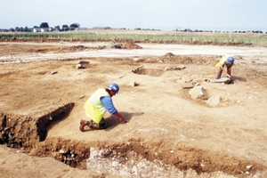
The Museum of London Archaeology Service (MoLAS) was commissioned by Union Railways (South) Limited (subsequently London and Continental Railways) to undertake a watching brief and detailed excavation between Wrotham Road and Scalers Hill, south of Gravesend, Gravesham, Kent, south of Gravesend, Kent. This work formed part of an extensive programme of archaeological investigation carried out in response to the construction of the Channel Tunnel Rail Link (CTRL). Fragmented sarsen stones with saddle quern.
Excavations at Tollgate have revealed Palaeolithic tools redeposited by colluvial processes at the base of a dry valley. The colluvial deposits sealed ancient soils indicative of an arctic environment (c 14,000 - 11,000 years before present).
Distinct spreads of sarsen stones were present to the east of Church Road. These have been considered as potentially the remains of a demolished Neolithic to early Bronze Age megalithic structure, but are more likely to be a natural accumulation, disturbed by medieval and later field clearance. A sub-rectangular cropmark enclosure, identified on aerial photographs to the east of Wrotham Road, is believed to be a Neolithic mortuary enclosure. It was preserved in situ beneath landscaping earthworks and not investigated in detail.
Evidence of a settled and cultivated landscape first appears at the end of the Bronze Age. A small scale settlement, established in the Iron Age to the west of Church Road, provides evidence of domesticated and processed crops and livestock, supplemented by foraged foods and game. Iron Age activity around Tollgate persists into the early first century AD, when a possible eastward shift in the focus of settlement and activity to the Henhurst Road area is recorded. Evidence for activity in the Roman period is dispersed along the length of the Tollgate zone, with a particular focus in the Henhurst Road area. A trackway junction including metalled surfaces and recut ditches, was established here cAD50 to AD70, apparently falling into disuse shortly thereafter. In the second century the area may lie on the periphery of a small settled area to the south and east of Henhurst Road. The character of Roman activity throughout the zone is agricultural, comprising field boundaries and trackways, with evidence for crop production and processing.
Archaeological evidence fades out by the mid-third century AD and no further features are recorded until the early medieval period, when new field systems and local routeways were established, suggesting renewed intensification in agricultural land-use in the 11th-14th centuries. Isolated pits at this time have produced evidence for wheat production and there is evidence that naturally occurring sarsen boulders were removed and broken up, presumably to improve fields for arable cultivation. Routeways and divisions of the agricultural landscape thereafter appear to remain stable, with little evidence for change to the modern period. Post-medieval chalk quarries are present across the Tollgate area. A brick kiln recorded near Cobham Service Station dates to the late 17th- to late-18th centuries and is likely to have provided brick and tile to the expanding communities of Gravesend, Singlewell and Cobham.
The fieldwork events covered by this report are:
- Tollgate (ARC TLG98) - Excavation
- West of Church Road, Singlewell (ARC CRS98) - Evaluation
- Package 330 Watching Brief (ARC 33098 / ARC 33098C) - Watching brief
