
HMJ Underhill Archive
Deborah Harlan, Megan Price, 2004. (updated 2013) https://doi.org/10.5284/1000234. How to cite using this DOI
Data copyright © University of Oxford unless otherwise stated
This work is licensed under the ADS Terms of Use and Access.

Primary contact
Prof
Helena
Hamerow
Institute of Archaeology
University of Oxford
36 Beaumont St
Oxford
OX1 2PG
England
Tel: 01865 278240
Fax: 01865 278254
Resource identifiers
- ADS Collection: 395
- DOI:https://doi.org/10.5284/1000234
- How to cite using this DOI
Overview
Information | Background | HMJ Underhill | Slides | Bibliography | About
The Slides
As Henry Underhill's lectures were not published, their content can only be inferred by the list of slides. However, by looking at the archaeology of these specific sites during the late nineteenth and early twentieth centuries, it is possible to understand Underhill's images in context. For the purpose of this web-site, the slides have been loosely organized by site and do not represent the original number or order. Catalogue numbers refer to the 1925 publication List of Haverfield and Underhill Collection of Lantern Slides in the Ashmolean Museum, Oxford.
In 1895, Underhill delivered two lectures to the Oxfordshire Natural History Society, both on antiquarian subjects, one on megalithic stone circles of Southern Britain, and another on the remains of Romano-British cities. In 1907, Underhill produced a series of slides on the subject of Windmills, delivering a talk to the Oxford Architectural and Historical Society in January of the following year. These lectures may have included photographic slides, though it is clear that many of his photographs were used as reference for his final painted versions.
The Great Stone Circles of Britain
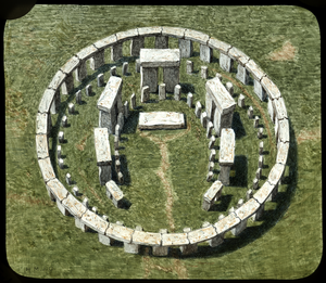
The late 19th century saw an increased interest in megalithic monuments, both in academic and popular circles. Many theories about the stone circles abounded, including the earlier ideas of John Aubrey and William Stukeley who connected the building of the stone circles to the Druids. Yet, because of the plethora of theories (some more rational than others), the academic world was beginning to take the study of stone circles seriously, weaning out the non-scientific ideas. This culminated in the British Association's 1899 Commission to formally study the 'Age of Stone Circles'. At the same time, the general public, including popular 'friendly societies' such as the Ancient Order of Druids, were creating their own mythologies about the monuments.
Terminology and etymology were considered significant, as evidenced by the stress on etymology in Arthur Evan's article on the Rollright Stones in Folk-Lore and displayed in Underhill's first slide, "Terms used to describe megaliths". Simple notions of diffusion were also commonly held. One of the missing slides from this set listed in the catalogue depicts a comparative image of menhirs from India, given by Henry Balfour, an Oxford anthropologist at the pitt Rivers Museum and a fellow member of the Natural History Society.
Avebury
Avebury had been explored by John Aubrey in 1648-9 and William Stukeley in the 1720s. However, it was not until the nineteenth century that more 'scientific' examination of the site took place: 1865 excavations by the Wiltshire Archaeological and Natural History Society, 1881 plans published by the Rev. W.C. Lukis and an account of the stones by the Revd A.C. Smith and 1894 excavations by Sir Henry B. Meux and his estate officer, Mr. Thomas Leslie. Despite these 19th century investigations, most of Underhill's plans and maps of this site seem to have been drawn from Stukeley's much earlier works. At least eight slides were drawn from personal observation and it is likely that he also used his own photographs as an aide memoire.
Rollright Stones
Though smaller than Avebury and Stonehenge, the sense of mystery at the Rollright Stones is magnified by the wealth of folklore associated with them. They have stimulated popular and academic interest from antiquarians such as Camden, Aubrey and Stukeley in the seventeenth and eighteenth centuries to Arthur Evans and Henry Taunt in the late nineteenth century. The site stands 700 feet above sea level on the Oxfordshire and Warwickshire borders. Underhill produced six slides on the The Rollright Stones, one of which shows his bicycle in the bottom left hand corner.
Stanton Drew
The circles are thought to have been originally noted by John Aubrey in 1664, and the first plan of them was published by William Stukeley in 1776. In 1877 C.W. Dymond wrote in the proceedings of the Somersetshire Archaeological and Natural History Society: "Three stone circles, two with attached avenues; a group of three large stones called 'The Cove'; two prostrate stones in a field to the west and one prostrate stone called 'Hautvilles' or 'Hackell's Quoit' to the north-north-east of the largest circle". At the time of writing, Dymond recorded 66 stones remaining. Though giving a full geometric description of the position of the circles and avenues, he offered no interpretation or suggestion of its origin or of its use. There are five Underhill slides of the stone circle at Stanton Drew, at least three of which are derived from publications. It is unclear if Underhill visited the site as there are no personalized views or photographs.
Stonehenge
Unsystematic investigations of the site of Stonehenge have been documented since the seventeenth century. Surveys included John Aubrey (1666), William Stukeley (1740), John Wood (1747), and Flinders petrie (1880). Because the site had become delapidated, stones fallen or removed, a guardian was appointed in 1820 to prevent further damage. It was in this state that Underhill documents the stone circle, relying on the reconstructions, plans and drawings of Edgar Barclay for some of the slides. It was only in 1918 that the site and the surrounding land was gifted to the state. More systematic excavation and restoration occurred in the 20th century [Cleal et al. (1995)].
The Ridgeway
Sites along the Ridgeway like Wayland's Smithy and the Sarsen Stones near Ashdown were regular excursion destinations for the Oxfordshire Natural History Society. It would have been natural for Underhill to include images of a site familiar to his audience. Many of Underhill's photographs from later visits to the White Horse at Uffington and the nearby Wayland's Smithy dating to 1918 and 1919 are in the Folklore Society's archives.
Some Buried Roman Cities of Britain
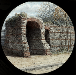
The early part of the nineteenth century saw a rise in interest in the remains of Roman Britain. This was, in part, due to the disruption caused to travel by the Napoleonic wars to the traditional Classical Lands of the Mediterranean. Industrial construction leading to new discoveries, the formation of national and local learned societies, and the beginning of cheaper rail travel for the growing middle classes to engage in leisure activities were additional factors. Guide books to many of the large Romano-British sites date to this period. Despite a slight falling off in interest in the middle of the 1860s and 1870s, the last decade of that century saw a revival with more professional and systematic approaches to new excavations and discoveries.
The majority of the slides in the 1925 pamphlet, List of Haverfield and Underhill collection of Lantern Slides in the Ashmolean Musem, are missing, including two of Roman London.
Bath
The antiquity of the medieval and Roman remains of Bath was known as early as 1540 with the observations of John Leland. However, it wasn't until the late eighteenth century that the facade of the temple of Sulis Minerva was exposed by the workmen laying the foundations for the new pump Room. Antiquarian interest dates to about that time with well-known scholars such as Camden and Stukeley visiting the site. However, the first intensive archaeological investigations of the site began in the mid-nineteenth century. Rescue excavations under the auspices of the city engineer continued until the first decade of the twentieth century.
Colchester
The first survey of the remains of pre-Roman occupation of the area and of the Roman town of Camulodunum was conducted in 1722 by Lufkin and Smith (published by philip Morant in 1748 in The history and antiquities of the most ancient town and borough of Colchester, in the county of Essex). Antiquarian interest and further surveys continued throughout the eighteenth and nineteenth centuries as did casual discoveries of mosaics, sculptures and other finds. However it wasn't until the early twentieth century that scientific investigations were carried out by such bodies as the Essex Archaeological Society and the Royal Commission on Historical Monuments.
Silchester
Evidence for eighteenth century visitors to the site include John Aubrey and William Stukeley. Then, walls were still standing and street outlines could be traced. Large amounts of antiquities were acquired from the site and unsystematic excavations had been conducted here before the late nineteenth century. From 1890 to 1909, excavations by the Society of Antiquaries aimed at high standards of method and practice were published in Archaeologia. The date suggests that Underhill would have visited the site in the middle of these excavations. From the description of his slides in the 1925 catalogue, it is clear that many of his slides showed recently excavated monuments, the South and West Gates, the Forum and the round Temple.
Wroxeter
Most of the slides listed in the 1925 catalogue indicate that the majority of Underhill's slides of the plans and views of Wroxeter were taken from the publications of J.C. Anderson (1867) and Thomas Wright (1877). However, paintings of objects (pottery, bronze and personal items) appear to be drawn from originals which Underhill may have seen in the Birmingham Museum.
North Leigh
The Roman villa at North Leigh in Oxfordshire is the only site in this set of slides that does not refer to a 'city'. The lecture had originally been prepared for the Midland Union of Natural History Societies at the Converzatione before their excursion the following day to the Stonesfield Quarry, famous for Buckland's megalosaurus, and the North Leigh Roman villa. It seems likely that the North Leigh villa was included in the lecture because of this visit.
North Leigh villa was first excavated by Henry Hakewell in 1813-1816. The villa contains preserved geometric mosaics. Underhill's hand-drawn plan of the villa is schematic with symetrically placed rooms which do not tally with a more exact plan. This slide is signed with his initials, a further indication that he did not copy it from published material, but drew it from his own observations. The photographs he took later of one mosaic floor are of immense significance. They are records of the floor before the 1920s when it was taken up, reconstructed and laid over concrete. Based on Hakewell's 1826 published sketch of the mosaic, the 1920s reconstruction of it is known to be incorrect. Only two of Underhill's photographs are definitely dated: one to 1898 and the other to 1899. The two undated photographs probably are earlier than 1899 and show more of the existing mosaic. Underhill shows different geometric motifs in each central circular device whereas the reconstructed mosaic as it is today displays the same repeated pattern.
Windmills
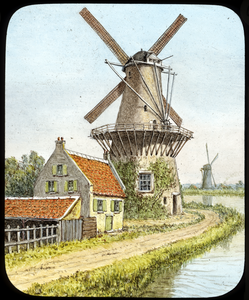
In 1907, Henry Underhill undertook a photographic survey of windmills of Oxfordshire and Berkshire. A set of mounted photographs along with a handwritten catalogue were presented to the Oxford Architectural and Historical Society and are now in Oxford University Bodleian Library. It is quite likely that this survey was part of a larger scheme to photographically record prehistoric, Roman and Anglo-Saxon remains; ecclesiastical architecture; domestic architecture; village scenes; ethnographic subjects; objects of natural history and portraits of historical significance. This scheme was first proposed at the Annual Congress of Archaeological Societies in 1894. They recommended that local societies organise and conduct the actual photography of their specific counties. In 1897, the Oxford Architectural and Historical Society voted to set up a sub-committee together with the Camera Club and the Natural History Society to coordinate the project for Oxfordshire. professor J.L. Myres was the chairman and Henry Underhill was listed as a consulting member from the Camera Club. It is not known how many of the photographic projects were actually completed.
