
Woodland Futures. Assessing Impacts of Forestry Strategies on the Historic Environment
Caron Newman, 2018. https://doi.org/10.5284/1047576. How to cite using this DOI
Data copyright © Newcastle University unless otherwise stated
This work is licensed under the ADS Terms of Use and Access.


Primary contact
Dr
Caron
Newman
Newcastle University
School of History, Classics and Archaeology
Newcastle upon Tyne
NE1 7RU
UK
Tel: +44 (0)191 208 7846
Resource identifiers
- ADS Collection: 3119
- DOI:https://doi.org/10.5284/1047576
- How to cite using this DOI
Introduction
The Government has made a commitment to increase the area of forestry coverage in England from its present level of 10%, to 12% by 2060. The Forestry and Woodland Futures project examined how the historic environment will be affected by woodland expansion, and where the historic environment could offer opportunities to inform and benefit planting schemes. In particular, the project looked at how the historic environment can contribute to the benefits of woodland expansion to the wider environment, society and the economy; and it identified the landscape types and areas most sensitive to change.
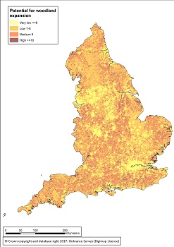
The project outcomes include both regional and national statements on the potential for woodland expansion and a sensitivity map of England plotting the capacity for woodland planting. The statements and maps were created through the assessment of historic and natural environment datasets. The datasets chosen had to be available for the whole country, with well-defined attributes allowing a scoring system for woodland potential to be applied, and thus providing a total to be given to each defined area. As the intention of the map was to assess the opportunities for woodland planting and its potential impact on the historic environment, both historic and natural environment attributes were compared to produce a more holistic result. The datasets were plotted against a measured grid of 1km squares, using a Geographic Information System (GIS) and a total score calculated, which indicated the potential for an area to absorb new woodland.
The regional statements and maps are based on the 159 National Character Areas, which are used by Natural England and other bodies to inform a range of environmental activities and to monitor landscape change. The statement for each National Character area provides a brief overview of the landscape character and its historic environment character, and a brief description of the opportunities for woodland expansion. Accompanying the National Character Area descriptions is a project report with details of the methodology used to produce the map, the data sources used, and a summary of the results. The report also includes a suggested framework assessment template for woodland expansion. The framework assessment is intended to inform the design and siting of new woodland in a manner that respects the historic character of places and protects the heritage assets within them. A grid of woodland potential is available to download as a shapefile.
Historic England commissioned the project from the McCord Centre for Landscape at Newcastle University in 2016.
