
Data from a Scheduled Monument Topographic Survey at Grim's Ditch, Buckinghamshire, 2020 (HS2 Phase One)
High Speed Two Ltd., INFRA Archaeology, 2024. https://doi.org/10.5284/1119342. How to cite using this DOI
Data copyright © High Speed Two Ltd. unless otherwise stated
This work is licensed under a The Open Government Licence (OGL).

Primary contact
High Speed Two Ltd.
2 Snowhill
Queensway
Birmingham
B4 6GA
United Kingdom
Tel: 08081 434 434
Resource identifiers
- ADS Collection: 4629
- DOI:https://doi.org/10.5284/1119342
- How to cite using this DOI

Overview
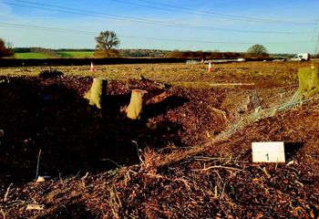
The segment of the Grim’s Ditch Scheduled Monument (List Entry 1021198), that lies within the site, is 145m long and is aligned northeast-southwest and has a visible upstanding bank on the west side of a linear ditch. The coverage demonstrated a continuation to the south of both the negative and positive elements but to the north, beyond the Monument, the area is entirely flat.
The results were able to rapidly capture detailed data which can be viewed as either orthomosaic photographic representations or as 3-dimensional models. This preserved the status of the Monument at one given point in time, provides a baseline of information to gauge future changes against.
