Fig 1 1
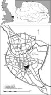
Figure 1.1: Location of Norwich, Norfolk, England and of the Castle Mall and Golden Ball Street sites
[ DOWNLOAD] (Full Resolution) right-click and save link
|
Fig 1 1
Figure 1.1: Location of Norwich, Norfolk, England and of the Castle Mall and Golden Ball Street sites |
JPG
Fig 1 1
Figure 1.1: Location of Norwich, Norfolk, England and of the Castle Mall and Golden Ball Street sites
[ DOWNLOAD] (Full Resolution) right-click and save link
|
1.04 Mb
|

Fig 1 2=11.2
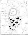
Figure 1.2: Plan of excavated areas at Castle Mall and Golden Ball Street, showing modern street names. Scale 1:2500
[ DOWNLOAD] (Full Resolution) right-click and save link
|
Fig 1 2=11.2
Figure 1.2: Plan of excavated areas at Castle Mall and Golden Ball Street, showing modern street names. Scale 1:2500 |
JPG
Fig 1 2=11.2
Figure 1.2: Plan of excavated areas at Castle Mall and Golden Ball Street, showing modern street names. Scale 1:2500
[ DOWNLOAD] (Full Resolution) right-click and save link
|
2.35 Mb
|

Fig 1 3=13.1
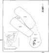
Figure 1.3: Excavation Area Numbers. Scale 1:2500
[ DOWNLOAD] (Full Resolution) right-click and save link
|
Fig 1 3=13.1
Figure 1.3: Excavation Area Numbers. Scale 1:2500 |
JPG
Fig 1 3=13.1
Figure 1.3: Excavation Area Numbers. Scale 1:2500
[ DOWNLOAD] (Full Resolution) right-click and save link
|
1.03 Mb
|

Fig 4 10
Figure 4.10: Period 1.1: Cemetery 2, reinterred child burial sk45210. Scale 1:50
[ DOWNLOAD] (Full Resolution) right-click and save link
|
Fig 4 10
Figure 4.10: Period 1.1: Cemetery 2, reinterred child burial sk45210. Scale 1:50 |
JPG
Fig 4 10
Figure 4.10: Period 1.1: Cemetery 2, reinterred child burial sk45210. Scale 1:50
[ DOWNLOAD] (Full Resolution) right-click and save link
|
236 Kb
|

Fig 4 140
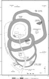
Figure 4.140: Location of churches and cemeteries (all periods) in relation to Norwich Castle's earthworks. Scale 1:2500
[ DOWNLOAD] (Full Resolution) right-click and save link
|
Fig 4 140
Figure 4.140: Location of churches and cemeteries (all periods) in relation to Norwich Castle's earthworks. Scale 1:2500 |
JPG
Fig 4 140
Figure 4.140: Location of churches and cemeteries (all periods) in relation to Norwich Castle's earthworks. Scale 1:2500
[ DOWNLOAD] (Full Resolution) right-click and save link
|
776 Kb
|

Fig 4 37
Figure 4.37: Period 1.3: Plan of Cemetery 3 (Farmer's Avenue), showing grave and skeleton numbers. Key: c=child, m=male, f=female, i=indeterminate (Areas 1, 6 and 22). Scale 1:200
[ DOWNLOAD] (Full Resolution) right-click and save link
|
Fig 4 37
Figure 4.37: Period 1.3: Plan of Cemetery 3 (Farmer's Avenue), showing grave and skeleton numbers. Key: c=child, m=male, f=female, i=indeterminate (Areas 1, 6 and 22). Scale 1:200 |
JPG
Fig 4 37
Figure 4.37: Period 1.3: Plan of Cemetery 3 (Farmer's Avenue), showing grave and skeleton numbers. Key: c=child, m=male, f=female, i=indeterminate (Areas 1, 6 and 22). Scale 1:200
[ DOWNLOAD] (Full Resolution) right-click and save link
|
1.41 Mb
|

Fig 4 51
Figure 4.51: Period 1.4: Plan of Cemetery 4 (St John, Timberhill/Berstrete), showing grave and skeleton numbers. Key: c=child, m=male, f=female, i=indeterminate (Areas 1 and 13). Scale 1:125
[ DOWNLOAD] (Full Resolution) right-click and save link
|
Fig 4 51
Figure 4.51: Period 1.4: Plan of Cemetery 4 (St John, Timberhill/Berstrete), showing grave and skeleton numbers. Key: c=child, m=male, f=female, i=indeterminate (Areas 1 and 13). Scale 1:125 |
JPG
Fig 4 51
Figure 4.51: Period 1.4: Plan of Cemetery 4 (St John, Timberhill/Berstrete), showing grave and skeleton numbers. Key: c=child, m=male, f=female, i=indeterminate (Areas 1 and 13). Scale 1:125
[ DOWNLOAD] (Full Resolution) right-click and save link
|
2.70 Mb
|

Fig 4 52
Figure 4.52: Period 1.4: Plan of Cemetery 4 (St John, Timberhill/Berstrete) showing burial types (Areas 1 and 13). Scale 1:250
[ DOWNLOAD] (Full Resolution) right-click and save link
|
Fig 4 52
Figure 4.52: Period 1.4: Plan of Cemetery 4 (St John, Timberhill/Berstrete) showing burial types (Areas 1 and 13). Scale 1:250 |
JPG
Fig 4 52
Figure 4.52: Period 1.4: Plan of Cemetery 4 (St John, Timberhill/Berstrete) showing burial types (Areas 1 and 13). Scale 1:250
[ DOWNLOAD] (Full Resolution) right-click and save link
|
827 Kb
|

Fig 4 54
Figure 4.54: Period 1.4: Plan of Cemetery 4 (St John, Timberhill/Berstrete) showing distribution of leper burials (Areas 1 and 13). Scale 1:250
[ DOWNLOAD] (Full Resolution) right-click and save link
|
Fig 4 54
Figure 4.54: Period 1.4: Plan of Cemetery 4 (St John, Timberhill/Berstrete) showing distribution of leper burials (Areas 1 and 13). Scale 1:250 |
JPG
Fig 4 54
Figure 4.54: Period 1.4: Plan of Cemetery 4 (St John, Timberhill/Berstrete) showing distribution of leper burials (Areas 1 and 13). Scale 1:250
[ DOWNLOAD] (Full Resolution) right-click and save link
|
642 Kb
|


