
Evaluating and enhancing the geoarchaeological resource of the Lower Severn Valley
Worcestershire Historic Environment and Archaeology Service, Gloucestershire County Council, University of Birmingham, University of Southampton, 2011. https://doi.org/10.5284/1000179. How to cite using this DOI
Data copyright © Gloucestershire County Council, Worcestershire County Council unless otherwise stated
This work is licensed under the ADS Terms of Use and Access.


Primary contact
Robin
Jackson
Project manager
Worcestershire Historic Environment and Archaeology Service
Woodbury
Worcester University
Henwick Grove, Worcester
WR2 6AJ
England
Tel: 01905 855401
Resource identifiers
- ADS Collection: 1053
- ALSF Project Number: 5725
- DOI:https://doi.org/10.5284/1000179
- How to cite using this DOI


Introduction
'Evaluating and enhancing the geoarchaeological resource of the Lower Severn Valley' (The Severn Geoarchaeology Project) is a collaborative project completed by two local authority archaeology services, those of Gloucestershire and Worcestershire County Councils, and three universities, those at Birmingham, Gloucester and Southampton.
The defined project area encompassed both active, and anticipated, areas of large-scale extraction of aggregates along a 50km stretch of the Lower Severn Valley, from Stourport to below Gloucester. Within this, a pilot programme of mapping, modelling and dating was undertaken across two main study areas which sought to begin to redress the historic lack of geoarchaeological and palaeoenvironmental research in the Lower Severn.
The primary aims of the project were to improve the methodological approaches and baseline information which underpin strategic planning and individual application decisions relating to widespread mineral extraction in this area, as well as evaluation and mitigation strategies designed in response to these. The project especially focussed on testing those techniques which have proved most effective elsewhere and were therefore felt most liable to be applied within the development control process in the Severn Valley.
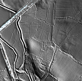
In particular, the project has identified the high potential of LiDAR derived digital terrain modelling to cost effectively map landform units (terraces, alluvial deposits, palaeochannels, etc) and cultural features within a GIS environment. The value of historic map and aerial photographic analysis to further identify and define palaeochannels was also demonstrated, along with the potential for applying carefully targeted Optical (OSL) and radiocarbon dating programmes in advancing understanding of chronological development of the valley floor.
The project has identified and mapped both geomorphological (landform) and cultural features and enhanced the understanding of known features of potential archaeological interest within the two project study areas. The geomorphological mapping and collated data provides essential background information for exploring and effectively managing the associated cultural landscape, the prehistoric and Roman aspects of which are 'masked' by alluvium across wide areas of the valley floor.
The newly mapped resources have been made available through the two county HERs. Together with existing information, these highlight the value of using a wide range of information sources within a GIS environment to map resources and develop predictive models for assessing the likely archaeological potential of any given area. The regular application of these techniques is therefore recommended for use in the management, selection and exploration of areas and individual sites proposed for mineral extraction in this river valley.
