
Franciscan Way, Ipswich - IAS5003
Suffolk County Council Archaeological Service, 2015. https://doi.org/10.5284/1034356. How to cite using this DOI
Data copyright © Suffolk County Council Archaeological Service unless otherwise stated
This work is licensed under the ADS Terms of Use and Access.

Primary contact
Suffolk County Council Archaeological Service
Bury Resource Centre
Hollow Road
Bury St Edmunds
IP32 7AY
Resource identifiers
- ADS Collection: 1922
- DOI:https://doi.org/10.5284/1034356
- How to cite using this DOI

Introduction
Circumstances of excavation
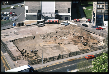
The site, which lay on the north side of the junction between Franciscan Way and Wolsey Street, had been occupied by a redundant garage and car showroom. Outline planning consent to redevelop the site was granted in 1988 subject to a Section 52 Agreement providing for an archaeological record to be made of archaeological deposits which would otherwise be damaged or destroyed. Excavation of c.1400m2 took place in 1990.
The development was never started and the site changed hands twice after the 1990 excavation with owners submitting new schemes for planning permission. Each scheme was larger than the previous one and each additional area was excavated by the Suffolk Archaeological Unit: 309sq m in 2002 and 176 sq m in 2006. The results of these two additional areas technically fall outside the remit of this project but they have been included as they have a direct bearing on the interpretation of the 1990 work.
Site constraints
The excavations were restricted to the footprints of the proposed developments. Following completion of the 1990 excavation, the site was not backfilled and the edges were sheet piled causing some damage to unexcavated deposits along the western boundary.
The site lies just above the normal flood limit of the River Gipping (now piped underground) only 50m to the west, but remains vulnerable to flood tides. Deeper features became waterlogged during excavation, especially towards the south-west.
The natural sands and gravels sloped from c.2.4m OD in the north-east to c.1.4m OD in the west. The north-south contours bend eastward in the south-west of the site, indicating either a relict meander of the Gipping or a small stream running roughly along the line of Wolsey Street/Cutler Street to the south.
Site summary
Two sherds of prehistoric pottery, six Romano-British and four Early Middle Saxon sherds were found, residual in later contexts. The features themselves all date from c.700 onwards.
Five boundary features, four wells and 16 pits can be assigned to the Middle Saxon period (MS: c.700-850) but no structures. A sequence of at least four phases of activity underlay the Early Late Saxon (ELS: c.850-900/925) road (0113) and was associated with small quantities of Ipswich ware and four sceattas deposited c.740-760. Over 11kg of iron slag was recovered from Middle Saxon contexts indicating the start of an industry which took off in the following ELS period; the assessment by the Ancient Monuments Laboratory indicates that both smithing and smelting were being undertaken on the site. It would seem likely that the west half of the site was meadow throughout the period with the wells providing drinking water for stock. The eastern half may have formed the rear of tenements to the east, where iron production was a significant activity.
The whole site was redeveloped by the end of the Early Late Saxon period with a major ditch and roadway, four structures and 81 pits, which in some instances show three phases of inter-cutting. The late ninth century is marked by a spectacular growth in the iron industry. Nearly 180kg of slag was recovered (94kg from ELS and 85kg from LS features), mainly from pits on the east side of the street and from the road surface itself (29kg). There is evidence for both smelting and smithing. At least one certain furnace base was recorded (0731), on the eastern edge of the road, just south of the centre of the site. It appears to be a pit with a vitrified clay ‘bowl-shaped’ feature in its upper levels.
Two wells (0009 and 0236) and 22 pits belong to ththe Middle Late Saxon (MLS: c.900/925-1000). Although there do not appear to be any buildings of this date, it is quite possible that the smithy building (1042), which appears to have been constructed in the ELS period, continued in use during at least the early MLS period. This is supported by the fact that the MLS yard (0234) appears to respect this structure. There appears to be a reduction of activity compared with the preceding ELS period. However, the metal working industry continued as a major activity. The absence of pits on the west end of the site implies that it was covered by the bank associated with the town ditch, of which no other evidence survives.
The most significant aspect of the medieval and later sequence was the use of the site for burial. The whole site lay within the precinct of the Greyfriars from c.1236.
A total of 150 individuals were excavated, which have been divided into three groups:
- Group 1 was an isolated small group of 4 graves on the eastern edge of the site, probably 12th/early 13th century in date.
- Group 2 was a large group of 87 bodies in the north-west of the site. The graves were in slightly haphazard north-south rows and buried deep enough for grave edges to be defined. It is suggested that burial proceeded from north to south and over a period of c.1250-1500.
- Group 3 was a group of 59 bodies in the centre of the site, mostly in north-south rows but with outliers. They were shallow burials, sometimes with multiple burials in one grave, and grave edges were more difficult to define. The Group 3 burials are clearly 16th century or later and post date the dissolution of the friary in 1534. The group is unusual both in burial custom and the nature of the population represented. The multiple occupancy graves suggest a higher than normal death rate, resulting in the need for more rapid burial as found at a time of plague epidemic
For the Post-Medieval period (c.1600-1900) a series of concrete stanchion pads at the north end of the site, associated with a number of concrete-floored tanks set below ground surface level, relate to the timber yard that was established in the late 19th century.
Further information can be found in the Site Summary which can be accessed by selecting the 'Reports' tab on the 'Downloads' page.
