
Reconstructing a Medieval Welsh Landscape: Exploring the Evidence of Nineteenth Century Field-Names and Land-Use Data in Landscape Archaeology
Andrew Seaman, 2016. https://doi.org/10.5284/1037857. How to cite using this DOI
Data copyright © Canterbury Christ Church University unless otherwise stated
This work is licensed under the ADS Terms of Use and Access.

Primary contact
Dr
Andrew
Seaman
Canterbury Christ Church University
North Holmes Road
Canterbury
Kent
CT1 1QU
England
Resource identifiers
- ADS Collection: 2281
- DOI:https://doi.org/10.5284/1037857
- How to cite using this DOI

Introduction
This project set out to provide two complimentary datasets through which the early and later medieval landscapes of the eastern Vale of Glamorgan can be explored. Firstly, the results of a computer-based ‘predictive model’ of early medieval settlement location, and secondly a comprehensive geodatabase of nineteenth century field-names and land-use information.
The predictive model of early medieval settlement location was developed in 2010 as a way of addressing the difficulties of identifying early medieval secular settlements in Wales (Seaman 2010). The model, which focused on a 100km2 area in the eastern Vale of Glamorgan, aimed to identify ‘core settlement zones’ where prospection techniques, such as geophysical survey, could be most profitably targeted. The predictive model is presented as a shapefile in which settlement zones are defined. Zones 1 and 2 are the most likely to contain evidence for early medieval settlement, and it is hoped that researchers will be able to use these to most effectively target prospection techniques.
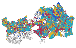
The geodatabase of field-names and agricultural land-use information is drawn from nineteenth century Tithe survey plans and apportionments. Field-names have long been acknowledged as vital sources of information by landscape historians, but archaeology has been slow to draw upon their evidence. This dataset will allow researchers to explore the archaeological significance of particular field-names, and by integrating field-name evidence with the predictive model, researchers will be able to target particular fields with prospection techniques. The Tithe surveys also provide the first comprehensive information about the spatial organization of the agricultural landscape, albeit several centuries removed from the Middle Ages. This data can therefore be used as a starting point from which to investigate the organisation of the medieval the landscape (Seaman 2010). Place-name specialists will also be able to use the geodatabase to place field-names within their wider landscape context.
Seaman, A., P. 2010: 'Towards a Predictive Model of Early Medieval Settlement Location: A Case Study from the Vale of Glamorgan', Medieval Settlement Research 25, 11-20.
The project was funded by the British Academy/Leverhulme Small Research Grant scheme.
