
Reconstructing a Medieval Welsh Landscape: Exploring the Evidence of Nineteenth Century Field-Names and Land-Use Data in Landscape Archaeology
Andrew Seaman, 2016. https://doi.org/10.5284/1037857. How to cite using this DOI
Data copyright © Canterbury Christ Church University unless otherwise stated
This work is licensed under the ADS Terms of Use and Access.

Primary contact
Dr
Andrew
Seaman
Canterbury Christ Church University
North Holmes Road
Canterbury
Kent
CT1 1QU
England
Resource identifiers
- ADS Collection: 2281
- DOI:https://doi.org/10.5284/1037857
- How to cite using this DOI

Overview
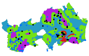
This collection includes the results of the predictive model and a fully georeferenced database of field-names and land-use information derived from twelve Tithe surveys. The data pertains to a 90km2 area in the eastern Vale of Glamorgan (an area roughly coterminous with the Dinas Powys hundred). The results of the predictive model consist of a network of ‘settlement zones’ labelled 1 to 4 in descending order of their likelihood of containing evidence for early medieval domestic settlement (1 most likely, 4 least likely; see Seaman 2010 for detailed discussion of the methodology of the model).
The database of field-names and land-use information is derived from information held within Tithe survey apportionments (dating to between 1838 and 1841) for twelve parishes within the study area. Two further parishes, Porthkerry and Barry, were excluded because their Tithe apportionments included neither field-names nor land-use information, and Highlight (a part of Wenvoe parish) was not included as its field boundaries were not recorded on the Tithe survey plans. A total of 4609 entries listing the name and/or state of cultivation of fields were transcribed from the apportionments and geocoded the British National Grid via a network of field-boundaries based upon the First Edition Ordnance Survey 6 inch 1 to a mile maps. Changes to a small number of field boundaries between the dates of the Tithe surveys and the Ordnance Survey maps meant that some fields could only be reconstructed to their approximate original proportions, but individual errors are unlikely to be greater than 10metres. There were also inconsistencies in the amount information provided in the Tithe apportionments, and whilst both field-names and state of cultivation information was provided for 1212 fields, 930 fields had only field-names, and 2467 fields had only entries for the state of cultivation. The names of settlements, houses, farms and associated structures have not been included in the database.
Where possible the state of cultivation information and field-names has been used to assign individual fields to one of six agricultural land-use categories: arable, pasture, meadow, mud flat, wood or orchard. A system of coding is used to indicate where field-names provide evidence for features of potential archaeological significance within or near to a particular field, or where contradictions between the state of cultivation and field-name indicate a change in land-use.
The interpretations of the field-names are derived from:
Field, J. 1972: English Field-Names: A Dictionary. Newton Abbot: David and Charles.
Pierce, G., O. 1968: The Place-Names of the Dinas Powys Hundred. Cardiff: University of Wales Press.
