
The Verderers of the New Forest Higher Level Stewardship Scheme
Peter Crow, Network Mapping, Cambridge University Technical Services, 2020. https://doi.org/10.5284/1095844. How to cite using this DOI
Data copyright © Forest Research, The Verderers of the New Forest, New Forest National Park Authority, Forestry England, Cambridge University Technical Services unless otherwise stated
This work is licensed under a Creative Commons Attribution 4.0 International License.

Primary contact
Archaeology Team
New Forest National Park Authority
Lymington Town Hall
Avenue Road
Lymington
SO41 9ZG
Resource identifiers
- ADS Collection: 3530
- DOI:https://doi.org/10.5284/1095844
- How to cite using this DOI
Overview
This archive is comprised of the bulk of the remote sensing data gathered by the HLS scheme for the Heritage Mapping project.
The three sets of data were gathered in a series of flights conducted by Network Mapping in March 2011. It was necessary to capture these data in winter months when the tree canopy was relatively thin, thus providing good visibility of the land surface in areas of woodland. It was also necessary to arrange the flights for daylight hours with little or no cloud cover, so that light conditions were suitable for photography. Altitude was no greater than 1,000 feet. An ‘eye-safe’, class IV laser was used to give better penetration of the forest canopy.
The Lidar data were captured at a density of between two and six laser hits per square metre, using a maximum half scan angle of 15 degrees and a swath overlap of 65%, and gathered as 3 dimensional geo-referenced point cloud data in a series of 1km squares saved as ASCII text files.
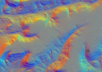
The point cloud data was processed by Cambridge University Technical Services (CUTS) to produce both Digital Terrain Models (DTM) and Digital Surface Models (DSM) of 0.5m cell size. These were subsequently used by Forest Research, part of the Forestry Commission, to generate a series of height, slope, aspect and hillshade dataset layers. These were provided as seven large landscape sections of varying sizes (approximately between 30 and 40 square km), rather than 1 square km tiles.
The aerial RGB colour photography and Infra-Red (IR) photography was captured at the same time as the Lidar. The colour photography was captured at a pixel size of between 6 and 10cms, whilst the IR images were between 10 and 12cms. The processed data were provided as 1km tiles.
The data were used to inform and guide landscape surveys of the New Forest's Crown lands, with a view to recording archaeological features of all periods of history. The resulting records of sites identified and recorded were deposited with the Hampshire Archaeology and Historic Building Record (Hampshire AHBR).
This collection includes the slope, aspect and hillshade dataset layers of the lidar, along with the aerial photography and IR data. It is made available here on the condition that the licence holder is informed of any work or discoveries made using it as a source.
