
Worcestershire Aggregates Resource Assessment
Worcestershire Historic Environment and Archaeology Service, Cotswold Archaeology, 2007. https://doi.org/10.5284/1000295. How to cite using this DOI
Data copyright © Worcestershire Historic Environment and Archaeology Service, Cotswold Archaeology unless otherwise stated
This work is licensed under the ADS Terms of Use and Access.


Primary contact
Robin
Jackson
Project manager
Worcestershire Historic Environment and Archaeology Service
Woodbury
Worcester University
Henwick Grove, Worcester
WR2 6AJ
England
Tel: 01905 855401
Resource identifiers
- ADS Collection: 792
- ALSF Project Number: 3966
- DOI:https://doi.org/10.5284/1000295
- How to cite using this DOI


Introduction
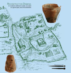
The Worcestershire Aggregates Resource Assessment results from a partnership project undertaken by Worcestershire Historic Environment and Archaeology Service (WHEAS) and Cotswold Archaeology. The project was commissioned by English Heritage through the Aggregates Levy Sustainability Fund (ALSF) programme and was designed to complement other similar ALSF-funded resource assessments, in particular those for the adjacent counties of Gloucestershire and Warwickshire.
The project was desk-based, comprising an assessment and synthesis of existing data and targeted enhancement of the Worcestershire Historic Environment Record (HER). The aggregate resources of the county and areas of extraction have been defined and mapped, and the impact of past, present and potential future extraction programmes on the archaeological resource has been summarised. The level of existing information relating to past activity in the aggregate extraction areas has been assessed and a research agenda drawn up to address areas of insufficient information. The latter has been refined through circulation of the report to stakeholders, a peer review conference and collation of resultant feedback.
The project has improved the amount and quality of archaeological information available for aggregate producing areas in Worcestershire and will support the provision of informed advice on the potential archaeological impact of aggregates extraction when reviewing existing planning permissions or considering new applications. Although covering the entire county of Worcestershire, a major element of the project has inevitably focused on the river valleys. Consequently the project has also contributed to the ongoing development of a framework for ALSF-funded projects in the Severn Valley and Severn Estuary; constituting one element within a broader strategy for reducing the impact of aggregate extraction (both terrestrial and marine) within this catchment.
The principal project outputs are a written and illustrated report and the updating of the Worcestershire HER, both of which will provide a vital input into strategic minerals planning and the knowledge base of the archaeology of aggregate areas of Worcestershire.
