
WHICH WAY IS UP? CONTEXT FORMATION & TRANSFORMATION:
THE LIFE AND DEATHS OF A HOT BATH IN BEIRUT
R. Thorpe, Archaeological Collaboration for Research and Excavation (ACRE)
WHICH WAY IS UP? CONTEXT FORMATION & TRANSFORMATION:
THE LIFE AND DEATHS OF A HOT BATH IN BEIRUT
R. Thorpe, Archaeological Collaboration for Research and Excavation (ACRE)
INTRODUCTION
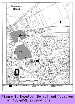 The following paper narrates the stratigraphic sequence within one room (Room 11) of
an Imperial Roman and Byzantine bathing complex (Building 709) partly within the excavation limits of BEY 045, excavated in the Downtown area of central Beirut (Figure 1). It then goes on
to explain the structure used used to interpret the room, and how, in their strictest
sense, the Laws of Archaeological Stratigraphy (Harris 1979, 1989) and the
archaeologists that apply them are challenged by sites that exist as partially extant,
though essentially buried, ruins within an archaeological excavation. The final sections of
the paper concern issues of archaeological methodology and the recognition of site
complexity, concluding that traditional methodologies, as practised in the archaeology of
the Middle East, and more recent thinking on archaeological method, as expounded by
Hodder 1997, fail to address deposit complexity adequately.
The following paper narrates the stratigraphic sequence within one room (Room 11) of
an Imperial Roman and Byzantine bathing complex (Building 709) partly within the excavation limits of BEY 045, excavated in the Downtown area of central Beirut (Figure 1). It then goes on
to explain the structure used used to interpret the room, and how, in their strictest
sense, the Laws of Archaeological Stratigraphy (Harris 1979, 1989) and the
archaeologists that apply them are challenged by sites that exist as partially extant,
though essentially buried, ruins within an archaeological excavation. The final sections of
the paper concern issues of archaeological methodology and the recognition of site
complexity, concluding that traditional methodologies, as practised in the archaeology of
the Middle East, and more recent thinking on archaeological method, as expounded by
Hodder 1997, fail to address deposit complexity adequately.
SITE LOCATION, NATURAL AND URBAN TOPOGRAPHY
The pediment of a large public building, most probably a temple (Lauffray 1945, Maquis
and Tarrazi 1996) and remnants of colonnades were found in the area to the south of the
baths. Excavations to the north in the area of the former Souks (markets) revealed a
large domus [4] of the peristyle/atrium type (Perring, et al. 1996), as well as other
residential and artisanal structures. A series of numbered shops to the north of what was
probably a colonnaded plateia (square) (Butcher and Thorpe 1997) or street (Williams,
et al. 1995) have also been excavated to the northwest of BEY 045. It is unlikely,
however, that this street or square is the decumanus maximus [5] of Roman Berytus,
which Lauffray (1945) suggested lay beneath Rue Weygand. The domus to the north of
the baths, as well as the portico and associated shops, were extant and in use during the
fourth and fifth centuries AD, a time when the baths of BEY 045 were at their most
grandiose.
Despite the identification of such a large public building, its exact limits are unknown.
The western extent of the bathing complex is thought to lie under the Munzer Mosque,
an historic building dating to the seventeenth century. It is certain, however, that the
baths extend beneath the Omari (or Great) Mosque to the east, though how far is a
matter of some conjecture. Predictive models of the street layout of Roman Beirut are
still unreliable, and the uncertainties regarding the full extent of the baths of BEY 045
reflect similar uncertainties about what is emerging as a complex and dynamic urban
plan.
The natural relief below the baths is easier to elucidate. The relief of the site slopes from
a high point of 7.00m OD (ordnance datum) in the west to 4.5m OD in the east. A break of slope to the
north-east leads down to the sea and is somewhat accentuated by what was either a
natural wadi (gully) or an earlier city ditch (author's own observation). Such a
commanding position, at a high point of the city, must have been dramatically reinforced
by the high ground 200 metres to the southwest, where the land rises steeply to 50
metres OD.
PREPARING THE GROUND: THE IMPERIAL THERMAE OF BEY 045
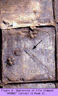
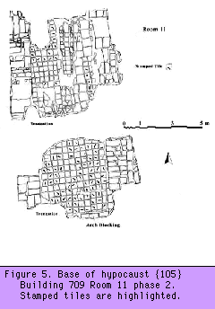
The third century saw a Severan embellishment of the baths. The drains were modified
and renovated, and a long series of cisterns was added to the east, possibly replacing an
earlier and smaller cistern. The hypocaust [6] of each room was also refurbished and
flue systems were consolidated or re-built. The late fourth and early fifth centuries also
saw an attempt to upgrade the baths. Two rooms (5 and 11) were inserted into the
demolished remnants of a former drain. The base of each room was paved with tiles
stamped INIMAS or INIBAGA (transliterated from Greek; Figures 4 and 5). These indiction stamps have been
dated to AD 423 or 431 -- during the reigns of Honorius and Valentinian III in the west and
Theodosius II in the east -- and have been sourced to either Constantinople or Antioch
(Hayes, pers. comm.). It is likely that the renovation of these rooms in this period formed
an Imperial commission built and paid for at imperial or civic expense.
The longevity of the building is well established, and Room 11 in particular was used for
a substantial period of time. During its lifetime, Room 11 was repaired and renovated
repeatedly. The hot pool built within it was built over the unconsolidated fill of an earlier
drain, a fact which is surprising given the usual solidity of Roman construction, especially
in public buildings. Subsequent drying and shrinkage of this unconsolidated material
resulted in the slumping and collapse of the floor of the pool above. Several attempts to
repair the pool were made and concrete was poured into the hypocaust to buttress failing
pilae [10]. Battles in the protracted war against collapse and structural failure were
fought and lost no less than nine times, before the final stages of the room's life during
the ninth century.
SITE
RECORDING SYSTEM AND PHASING STRUCTURE
The site was excavated and recorded using the single-context recording system, within a
five-metre grid outlined in Spence (1990, 1993). The record sheets were adapted from
those used by the Museum of London Archaeology Service (MoLAS). Only direct
stratigraphic contacts were recorded onto the context sheet in the 'relationships field',
while physical relationships were annotated where the excavator felt necessary. The site-wide sequence was compiled from and validated against the plans and context records
during the excavation, and checking of the sequence was completed as soon after the
excavation as funding allowed.
The structure adopted to group and phase the context records has been outlined
elsewhere (Shepherd 1992; Thorpe 1995; Thorpe and Williams, in press; Williams 1987;
Williams and Pearson 1992). The system used in Beirut differs from that used in London and York, and by other urban units, only insofar as sub-group [11] and
group [12] numbers derive from a continual sequence rather than the sub-group
being a numerical subdivision of the group number. This approach to phasing is based on
the hierarchical grouping of physically superimposed episodes of deposition or truncation,
which is in turn based on processual association by direct stratigraphic link. Associated
contexts are grouped into activities based on the definition of events of construction, use
and disuse. These sub-groups then form the basis for higher units of interpretative
association (groups), which encompass inferred temporal-spatial relationships between
archaeological entities not directly linked by a stratigraphic chain and define buildings,
open areas, roads, and so forth. Post-depositional processes of context transformation or
horizontal truncation are shown on the sub-group matrix with a red dash-double dot line
(Figure 7), demonstrating activity that is inferred by the archaeological record but which
has no physical form per se. This enables an interpretative understanding of the site
sequence to be demonstrated graphically without enshrining a single scheme of
perception within the primary context record of the site. By using keywords to express
processual interpretation at sub-group level, the sub-group matrix may equate to
Adams's (1991, 1992) traits or attributes matrices.
THE STRUCTURAL SEQUENCE OF ROOM 11: STRATIGRAPHIC COMPLEXITY OVERESTIMATED?
Ceramic spot dates suggest that the internal division of extant space, demonstrated by
the superimposition of Rooms 20 and 11, had been established some time during the
middle first to second century AD. The floors relating to this period, however, had been
entirely removed by horizontal truncation and the insertion of a later phase of Room 11
in the fifth century. The southern end suffered further truncation with the insertion of a
concrete floor during the first half of the twentieth century. The northern section of the
room was also truncated during the refurbishment of a Mamluk building in the sixteenth
century. The mixed deposits cleaned from the top of the sequence after initial machine
clearance in the south of the room represented reworking of the upper layers during
robbing. These upper layers were overlain by construction trample from the laying of the
floor. To the north, these deposits were absent, having been removed unrecorded by
workers from the Directorate General of Antiquities of Lebanon before our involvement
with the site.
Below this horizon of reworking, mortar bedding on top of the suspensurae [14] of the
room's hypocaust retained some fragments of grey marble flooring {609}. It was clear
that the robbing and removal of the marble floor above the suspensurae had occurred
while the floor itself retained its horizontal continuity. The mortar bedding below this
floor, though not part of its construction, had previously slumped, and in so doing, had
contributed to the preservation of a low sandstone wall, the top of which showed
evidence of truncation due to the robbing witnessed above. This sub-group retained its
structural association with the surrounding deposits composed of distinct and separate
layers of mortar and tile (each representing episodes of deposition, possibly phases of
consolidation), yet neither was in situ. Phase 13, then, represents the products of collapse
or slumping of deposits which are associated with the construction of Phase 12.
The wall itself had been built on an earlier floor {117} that had collapsed, reusing
the debris of the previous floor in its makeup. This collapsed floor in turn sealed a phase
of foundation repair {113}. Earlier flooring {112} was incorporated into this
consolidation; in this way the subsidence to which {113} was a response again
necessitated the incorporation of an earlier structure and the products of its
transformation (reworking) into its foundation.
A familiar pattern emerged in both the excavated deposits and in the diagram of the room sequence constructed on site during record checking. The definition
of episodes of horizontal truncation and/or floor removal on site seemed to coincide with
'crossing lines' at nodal points on the matrix. What had appeared a relatively straightforward
archaeological sequence began to provide an object lesson in archaeological stratigraphic
problem solving and interpretation. The empirical sequence of deposition demonstrated
that our initial assumptions had grossly underestimated the complexity of Room 11.
Two successive earlier sequences of floor removal and re-building lay below (Figure 7,
phases 3 and 4), each characterised by the addition of support to earlier structural
elements. Phase 2 truncated an earlier phase of heated room, which was itself associated
with the construction and use of a flue and the blocking of a doorway, presumably used
in an even earlier phase of Room 11 lost when the main central drain was inserted. THINKING
STRATIGRAPHY: INFERRING PROCESSES OF DEPOSITION AND POST-DEPOSITIONAL
TRANSFORMATION
The identification and definition of physical and spatial entities with real edges (no matter
how blurred) is empirical, i.e. it is not a matter of inference or interpretation, unlike our
perceptions of what these entities mean or signify. The inference potential of a context is
based upon the relational qualities of composition, displacement, contents and
constituents, and is thus related to definition of deposit status (Roskams 1992: 28).
Determining which way is up is at the core of stratigraphic excavation; indeed, the top of
the archaeological sequence must be determined before the excavator can apply the Law
of Superposition (Harris 1989: 30) to the rest of the strata. In Room 11, physical
superposition, based on the assumption of sequential deposition determined by gravity
was of limited use when forming concepts of the archaeological sequence. Two independently
formed sequences of hypocaust superstructure and flue-firing deposits were physically in
superposition -- the suspended floor physically lying above the later flue-firing deposits.
However, linear stratigraphic and temporal succession could not be inferred between the
two. Instead, we had to recognise that we were dealing with a sequence that had two
tops -- two 'ups' -- and that the practicalities of excavating these two superimposed
multilinear [15] sequences, complex in their own right, required that we could not
physically excavate the room stratigraphically (from the top to the bottom).
Our approach to Room 11 relied on conceiving of the room and its constituent contexts
at sub-group level, as well as at the level of the individual context. The application of the
Law of Superposition, Original Continuity, and Original Horizontality (Harris 1989),
within the individual sequences defined episodes of truncation during excavation,
clarifying which way was up. These Laws were of little use between the superimposed
sequences of firing and superstructure, despite physical links. Clarifying the bottom and
the top of each sequence, especially at the end of a multilinear strand, highlighted
stratigraphic problems, or rather instances in which archaeological strata could not possibly
have been doing what at first they appeared to do. This led to the inference of processes
of deposition with which to try and explain these phenomena, suggested and supported
by the stratigraphy. It would have been easy to assume that a single period of post-depositional transformation had affected the deposits within Room 11 and had occurred
during its disuse -- or indeed caused its disuse. The frequent and periodic episodes of
anthropogenic modification and consolidation of the structure could only be explained as
a response to an event (or events) that made these modifications necessary.
The character of the repairs provided the interpretative link that could be used to suggest
why these repairs had been undertaken. The reflexive relationship between interpretation
and methodology, which resulted from sound stratigraphic observation and hypothesis
testing, enabled inferences about processes of deposition and transformation to be made.
By adhering to the Laws of Stratigraphy as a means of understanding the order of
deposition and identifying transformed strata, we had a tool with which to unravel the
sequence even in a situation where the direction of 'up' could not be taken for granted.
Yule (1992: 20) defines a reworked layer as 'one that has undergone mixing and post-
depositional transformation'; I would like to offer some clarification of this by breaking it
into two definitions. A reworked deposit is one which has been modified by
anthropogenic actions: the re-deposition of material generated from the digging of
negative features or the demolition of positive features. Post-depositional transformation,
on the other hand, occurs as a product of natural processes. In this way, these two terms equate to
Matthews's (1993: 59) C-Transform (cultural transformation) and N-Transform (natural
transformation), respectively. ISSUES
OF COMPLEXITY AND RESIDUALITY: INTERPRETATIVE MODELLING BASED ON
INFERRED PROCESSES OF REWORKING AND TRANSFORMATION
All excavation is a reflexive process. The dynamic relationship between archaeologist
and archaeological stratigraphy is reflected in the continued hypothesis forming, theory
testing and re-evaluation practised by all archaeologists at what Hodder (1997) calls 'the
trowel's edge'. This process however relies on the excavator determining the direction of
'up' so that 'he [sic] can ... apply the Law of Superposition accordingly' (Harris 1989: 31). Put
simply, the excavator must have a handle on the formation processes that occurred on the
site before she or he can excavate it. Indeed, the excavator has no choice but to make these
assumptions, usually derived from laws of geological sedimentation, before deciding
on the most apt methodological tool to apply. The fact that we work with a set of
archaeological perceptions, which are constantly and rigorously tested and re-evaluated,
does not invalidate or detract from this approach to stratigraphy, nor does this critical
self-awareness mark a paradox. It is this approach that does not enshrine the separation of
observation and interpretation, but which demonstrates intellectual and methodological
rigour. The process of 'thinking stratigraphy', that is the process of testing, examining
and re-evaluating within a framework of what is stratigraphically possible, is one of the
keys to understanding deposition, site, and (urban) complexity. It need hardly be stressed that
this may also enable richer multivocal interpretations of the social processes behind
urban formation. If, as archaeologists, we are interested in understanding urban, site, and
deposit complexity, it is essential that we realise that many interpretations (at the trowel's
edge) are based (often solely) on the form of deposits or structures: we infer function from their form and then blithely use this to ascribe deposit status. It is also important that we realise that this
practice is fundamentally flawed and that status is a property of the relationship between
the deposit and the assemblage it contains. The reflexive relationship between
interpretation and appropriate methodology is at the core of sound stratigraphic
approaches to excavation. The conceptual tools provided by the Laws of Archaeological
Stratigraphy, when applied well, allow us to identify complexity and seek many
explanations for this complexity while excavation is still in progress. A more complex model of deposition and reworking is posed by Figure 15, in which deposits
and structures are reworked after their original deposition. In this model, the function of
a context may be altered without any alteration to its form. For example, an episode of
demolition can also be used as a rubble foundation for a floor. The interpretation of the deposit
as such is based on its form, composition, and its physical and stratigraphic position. In
this instance, the deposit has been reworked and its original function can be inferred, as can
its secondary form, though its status has been altered. The process of anthropogenic modification characteristically produces multilinear
sequences (though multilinear sequences do not only result from this). The crossing
lines on the sub-group matrix of Room 11 are often indicative of reworking in the form
of horizontal truncation. Although they are not proposed as a reliable index of site
formation in themselves, crossing lines can demonstrate deposit complexity, in the same way that the
size of a matrix represents the number of contexts recorded.
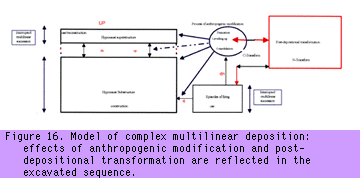
The most complex model (Figure 16) attempts to show the non-linearity of deposition, post-depositional transformation and anthropogenic modification, and the fact that in each case
the direction of 'up' can change. The process of anthropogenic modification has a
recursive link with that of post-depositional transformation; likewise, the patterns of
deposition are also linked to both transformation and modification. The sequences of
deposition, represented by episodes of firing, alteration to the hypocaust substructure
(evidenced here as the pilae and floor supports) and the superstructure (the actual floor,
its fittings, and foundations), all have the potential for the direction of the tops of their
respective sequences to be inverted physically, depending on the processes of deposition,
reworking, or transformation. The sequences represented by these episodes of deposition
will be interrupted -- that is they themselves would have been truncated -- reworked, redeposited, and transformed. Residuality within these sequences is characteristically high,
and the nature of the transformation or modifications also increases the chance that later
material will be introduced into earlier, though physically sealed, contexts. It is likely, then,
that the groups within the ceramic assemblages can represent original composition and
deposition as well as events of subsequent modification and transformation. In the case of Room 11, post-depositional transformation was represented by several
episodes of slumping and downward displacement of strata. The basin of this
transformation is reflected in the slumped base of the hypocaust (Figure 17) and is shown as
an interface physically at the base of the sequence. However, this basin has itself been
transformed, as demonstrated by the contextual relationships of the repairs and
consolidation to the hypocaust substructure. In each case, the transformation produced a
response in the relaying of the suspended floor and the insertion of additional structural
support. The displaced strata retained their internal in situ relationships; however, the entire
sequence as discovered had also undergone transformation during its ruination and was
no longer in situ as originally deposited. The fact that post-depositional transformation
of this kind had dictated various processes of modification, re-building, and strengthening
served to highlight the fact that these two processes of transformation had occurred not
just once but repeatedly. For example, a complete pilae stack had collapsed while still
physically contiguous with its base, transformed -- via natural processes -- from a floor support
(construction) to a collapsed floor support (structural failure/disuse). It was then
incorporated in its fallen form as an aggregate into the concrete of sub-group {110}; as such
it had become part of an episode of reconstruction. THE
TROUBLE WITH GHOSTS: REFLECTIONS ON A REFLEXIVE SITE METHODOLOGY
The study of site formation and complexity hinges on the approach of the individual
archaeologist to the deposits and structures she or he is about to dismantle. This approach
relies implicitly on a structured and in-depth understanding of the 'laws' of archaeological
stratigraphy. These laws have always existed, and those sites that have been excavated well
before and since the advent of open-area excavation and stratigraphic recording, are without
doubt done by women and men who had an intuitive understanding of these laws, such as
Wheeler (1954: Figure 16) and Kenyon (1957: 122-44), for example. However, Harris's
articulation of these laws clearly and succinctly provided a format in which
stratigraphic and relative temporal succession could be shown. The development of
excavation techniques that enshrined the importance of plan as well as sequence and the
recording of that sequence in a demonstrable way, in a format that allows units of
stratification to be overlain in plan, enables stratigraphic or physical relationships
between deposits to be articulated. These processual advances were devised during the
burst of rescue excavation in the 1970s and the development-led excavations in historic
cities in Britain (most notably London) in the late 1970s and 1980s, as a
mitigation strategy against the total loss of archaeological deposits. Their basic motivation
was to standardise the quality of archaeological recording and recovery among a large
workforce with disparate levels of skill, while creating an archive that could later be reworked and interpreted by any archaeologist in the light of new discoveries and
approaches. In essence, the emphasis on empirical objectivity when recording and the
precise planning (to within a 20-millimetre tolerance over 5 metres) of the limits of observable
archaeological phenomena enables the multivocal discourses discussed by Hodder
(1997) and Chadwick (1998), despite their development within processualist paradigms
and by a professionalised workforce.
Recent observations on the use of the Harris matrix are interesting, though I feel it is
possible that Adams (1992: 14) and Lucas (forthcoming) expect that the matrix, or some
variation of it, to act as a panacea for difficulties of site interpretation. The Harris
matrix is a tool with which stratigraphic succession is tabulated. It is an exercise in
topology and ascribes equal importance to each recorded unit of stratigraphy; that is all it
does. Other inferential levels of information such as post-depositional transformation,
horizons of truncation, deposit reworking, and demolition -- in themselves all attributes of the
processes of construction, use, and disuse -- are expressed on matrices at sub-group or
group level and are articulated in sub-group and group discussions. The allocation of
ghost contexts, as at Çatalhöyük, is in my opinion methodologically incorrect, since it
objectifies and embeds an interpretation within the narrative of site sequence. The
example Chadwick (1998) cites is worthy of repetition: It is procedurally incorrect to allocate a context number to an event, the existence of
which cannot be empirically demonstrated. If it cannot be drawn, no photograph taken,
no description of its physical manifestation written and no stratigraphic succession
indicated, then it is a supposition with no empirical basis upon which to postulate its
existence in the physical world. Chadwick's interpretation of why a skeleton was found as residual material within the backfill of another burial is coherent, but it is only one of a number of equally valid interpretations. The definition of an
archaeological context as an indivisible unit of deposition or truncation is the working
definition behind modern archaeological practice and stratigraphic excavation.
Demonstrating the inferred process of deposition at sub-group level as an annotation on
the matrix or within the discussion adds a depth and colour to interpretation without
compromising the integrity of the site record. Giving this absent action a number,
however, and putting it on the stratigraphic matrix as a unit of deposition or truncation are
not justifiable in archaeological theory and practice.
Interpreting complexity requires a rigorous adaptive and reflexive methodological
approach. The Laws of Stratigraphy articulated by Harris (1989), when applied to dry-land sites,
intrinsically rely on the excavator understanding which way is up. Supposed instances
where the Laws of Stratigraphy do not apply, such as examples of late drain fills in an
early capped drain, only enforce two points. Firstly, archaeological entities, what some
would call 'features', have depositional complexity and phases within them; hence the fills of a
drain would not be sub-grouped with contexts relating to that drain's construction.
Secondly, the Laws of Stratigraphy apply to sites excavated on dry land, provided the
stratigrapher understands which way is up.
CONCLUSIONS
In this paper, I have tried to make several points about approaches to stratification and
site complexity which I feel have some bearing on current discourses on archaeological
field method. The application of the Laws of Stratigraphy as a means of unravelling site
formation processes is not simply a mechanistic process. It is a process that requires
'thinking stratigraphy' in a dialectic relationship between empirical observation and
working interpretation. As a means of expressing the sequence of deposition, the
stratigraphic matrix is an invaluable tool both for helping to conceive
which way is up and to promote a sense of three-dimensional stratigraphic self-awareness.
This requires the excavator constantly to examine and re-examine inferred interpretations
about deposit function and interpretation based purely on physical form, and it is a means
of being able to understand stratigraphic complexity and respond to the recording
demands of it.
Despite the presence of multilinear sequences on the more complex sites that we
excavate, linear explanations of how the site formed often dominate interpretations. This
reductionist simplicity encourages perceptions of scientific, objective truths which
provide their own validation. We assume that observations were made under rigorous
conditions and that, though we may disagree on matters of interpretation, the means to
reassess the basis of those interpretations is available in the archive. However, the crux
of the matter is that if the approach is flawed and an understanding of the principles of
stratigraphy is missing, we risk producing only caricatures of site complexity, imbued
with scientific unequivocality. In this sense, I feel that the current discourse on reflexive
field method is actually in danger of missing the point, by underestimating that
complexity. In accepting that there are grey areas and blurred interfaces within and
between units of stratigraphy, we must also accept that we have to try and recognise this
complexity, try to understand what it might mean and how it can be characterised. This
has to be done with the rigour of empirical stratigraphic recording. Harris's
matrix helps in this, as it clearly expresses sequence; it is not of itself reductionist, as it
allots equal weight to all recorded contexts, but neither is it an end in itself. The occurrence
of crossing lines on matrices is often taken to denote either a mistake during excavation
or in the drafting of the matrix. This is not the case. These crossing lines could also be explained with
the phrase 'you cannot represent a three-dimensional entity in two dimensions'. However, what the
crosses might mean and why they exist at all are questions seldom asked. Matrix two-dimensionality is
not a problem; it forms an easily understood tabulation of complex strands of succession.
Indeed, the fact that it is two-dimensional may be a boon. The more stratigraphically
complex the site, the more lines cross. Could it then be true that crossing lines may
denote complexity? Should we not then try and define and explain that complexity, within
the framework of site stratigraphy, rather than assuming that it is an instance on the edge
of chaos where the laws of the physical world need not apply?
My participation in the rescue excavations in Downtown Beirut
<http://www.aub.edu/aub-online/faculties/arts_and_sciences/archaeology/index.html>
brought me into direct contact with various excavation methods and many different
conceptions of what constitutes a unit of stratigraphy and the way it should be recorded.
All of these methods, however, produce a serviceable 'result' of differing quality and
depth, all produce datable assemblages and structures, and most are a product of the
level of site preservation and the traditions of Middle Eastern archaeology. Many of
these methods, such as those using spits as unit of stratification (planum excavation) or leaving
structures on pillars of stratigraphy as a matter of course, are also at risk of producing a
caricature of the site, let alone its complexity. Yet this is because the better the
preservation of the site, the more easily readable it is assumed to be. This is a dangerous assumption,
if we are at all interested in recovering data that can help us understand complexity.
It seems to me that neither of the above approaches are contextual in terms of trying to
understand site complexity while on site. Both disregard it: one because it is ill-equipped
with the relevant stratigraphic tools to recognise this complexity; the other because it sees
empirical observation and recording as being antithetical to developing and documenting
on-site interpretation, rather than being at the very core of truly reflexive excavation
methodologies.
In applying the Laws of Archaeological Stratigraphy to Room 11 and critically examining
which way was up, an insight into formation processes was gained which reflected
the dialectic, as opposed to a paradox between stratigraphic excavation and
interpretation. Demonstrably, there are Laws of Archaeological Stratigraphy. Instances
where they seem not to apply serve as valuable markers of complexity.
As such, these instances require critical and rigorous re-examination of which way is up
and of one's own stratigraphic self-awareness. Discarding of basic principles in an attempt
to demonstrate supposition is in danger of restricting our ability to
characterise and understand site complexity. By adopting a rigid response, and
allotting a context number to an entity that has no trace in the physical world and then
enshrining this in the stratigraphic matrix at context level, one is not seeking to
understand complexity, or acknowledge the dynamic nature of archaeological sites. Instead, one
is engaged in an exercise in bending the record to one's own scheme of perception, as a
means of justifying that perception.
There is no single truth lying at the trowel's edge, nor a single interpretation, only a
superimposed sequence of units of archaeological stratigraphy and the assemblages they
contain. We do not approach this interface as passive sponges ready blindly to document
self-evident facts, but neither are we, nor should we be, locked into a single perception of
what there is. The process of building stratigraphic self-awareness occurs at that point
where the excavator first defines which way is up and starts with the recognition and
definition of physical entities with substance or form or both. Retaining a three-dimensional
appreciation of where one is in the site sequence, i.e. thinking stratigraphy at context and
sub-group level makes possible the adoption of an intelligent and reflexive excavation methodology. Reflexive method relies on the excavator being anything but passive.
However, it also leaves the individual context record open to re-interpretation by anyone
who cares to do so. Truly reflexive excavation methodologies are born from one's
approach to the strata at the trowels edge, and one's approach to the co-workers who
use that trowel.
As a discipline, field archaeology has invested over a century in developing field
methodologies, and one hopes that this development will continue. Soil
micromorphology and other disciplines continue to improve our understanding of the
physical processes of deposition and micro-stratigraphic analysis will certainly enrich the
histories that we have to tell. It is unlikely, in my opinion, that the principles of open-
area stratigraphic excavation -- recording based on the delineation of the extents of each
context, their graphic recording on a grid, and the recording of their position within the
sequence according to the principles of archaeological stratigraphy -- will be supplanted.
The tools we use to execute various parts of this process will no doubt change, and I am
not suggesting that we are at a zenith in terms of archaeological method. However, I
suggest that in our approach to stratification born of the publication of
'Principles' (Harris 1989), we are getting deeper than ever before into the substance of complexity and the interplay of
social and economic factors involved in site formation.
The tools that enable us to write richer, fuller histories already exist in various guises and
continue to develop. The only obstacle to writing these histories is our own mindset. The
blurred edges require only that we think harder about complexity, stratification,
contextual association and status. ACKNOWLEDGEMENTS
I am equally indebted to many friends and colleagues, too numerous to mention, from the units for
which I have worked for many discussions on stratigraphy and archaeological methodology. The
AUB-ACRE team who worked so hard in Beirut all deserve special praise, especially Richard
Wooley for his exertions with Room 11. professor Helga Seeden, Chris Cumberpatch, Adrian
Chadwick, Dominic Powlesland, Paul Reynolds, and Tim Williams all read earlier versions of this
text; Paul Reynolds also provided the spot dating information. However, it goes without saying
that, while owing much to all the above, the opinions expressed and any mistakes are my own.
The photographic images presented in this paper are copyright of the Director, Lebanese
Department of Antiquities, and were taken by Dylan Hopkinson. Illustrations are by the
author. Copyright © R. Thorpe 1998
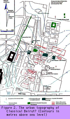 The baths of BEY 045 lay in the eastern lee of a high peninsula of ground
stretching from the Grand Serail (CDR) in the south to the Majidiyeh Mosque in the
north. Previous archaeological work has suggested that the site (Figure 2), which
contained part of a large bathing complex, was built on or around the forum of Roman
Berytus (Beirut) and was flanked to the South by a civilian basilica. Recent excavations
have shown that it is likely this basilical structure was associated with the baths of BEY
045 either as a Kaisersaal [2] or palaestra [3] and was not in fact the civilian basilica of
Berytus (Thorpe, in press).
The baths of BEY 045 lay in the eastern lee of a high peninsula of ground
stretching from the Grand Serail (CDR) in the south to the Majidiyeh Mosque in the
north. Previous archaeological work has suggested that the site (Figure 2), which
contained part of a large bathing complex, was built on or around the forum of Roman
Berytus (Beirut) and was flanked to the South by a civilian basilica. Recent excavations
have shown that it is likely this basilical structure was associated with the baths of BEY
045 either as a Kaisersaal [2] or palaestra [3] and was not in fact the civilian basilica of
Berytus (Thorpe, in press).
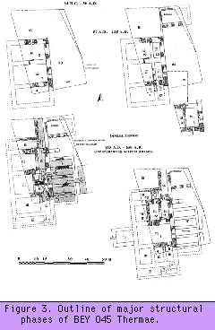 The building sequence on BEY 045 consists of a series of superimposed discrete and
temporally separate events. The palimpsest of occupation, renovation, re-building, and re-use was evident both in superimposed deposits and in the walls which apparently had
been re-built at various times. Building 709 (Figure 3) was established as a bath during the
early first century AD. The early second century saw the baths undergo a major phase of
re-building as a large central drain was inserted along the north-south axis of the
structure. The form of the building and its axial symmetry were then altered to resemble
those of the imperial thermae of Rome.
The building sequence on BEY 045 consists of a series of superimposed discrete and
temporally separate events. The palimpsest of occupation, renovation, re-building, and re-use was evident both in superimposed deposits and in the walls which apparently had
been re-built at various times. Building 709 (Figure 3) was established as a bath during the
early first century AD. The early second century saw the baths undergo a major phase of
re-building as a large central drain was inserted along the north-south axis of the
structure. The form of the building and its axial symmetry were then altered to resemble
those of the imperial thermae of Rome.
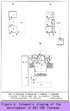 Rooms 5 and 11 were special additions to the baths and served to reorient and
establish a fluidity in the architectural symmetry of the building (Figure 6) that had been
lacking before the second century AD. It was the establishment of this symmetry that
broke up the regular 'row type' [7] linear progression of earlier phases through the
building to the caldarium (hot room) [8]. Instead, this symmetry established and
accentuated the independently operating halves of the baths. It created a more complex
bathing sequence that could be enjoyed and tailored by selecting or omitting different
gradations of heated room from the comfort of the tepidarium (warm room) [9] before
progressing to the caldarium. As such, this division of space may represent some increase
in status as well as the complexity of bathing offered, possibly reflecting the growth
in affluence and security among Beirut's inhabitants. This security and status, or their
perception at least, were further reinforced during the third century and again in the early
fifth century with the refurbishing of the baths under Imperial patronage, there is also
evidence of a later refurbishment under the Emperor Justinian (AD 527-565). The
inclusion of the stamped tiles in the fifth-century refurbishment made an overt political
statement regarding the stability of the East and the continuation of an essentially
Hellenised version of empire, while the Empire of the West suffered the turmoil and
insecurity of economic and military failure.
Rooms 5 and 11 were special additions to the baths and served to reorient and
establish a fluidity in the architectural symmetry of the building (Figure 6) that had been
lacking before the second century AD. It was the establishment of this symmetry that
broke up the regular 'row type' [7] linear progression of earlier phases through the
building to the caldarium (hot room) [8]. Instead, this symmetry established and
accentuated the independently operating halves of the baths. It created a more complex
bathing sequence that could be enjoyed and tailored by selecting or omitting different
gradations of heated room from the comfort of the tepidarium (warm room) [9] before
progressing to the caldarium. As such, this division of space may represent some increase
in status as well as the complexity of bathing offered, possibly reflecting the growth
in affluence and security among Beirut's inhabitants. This security and status, or their
perception at least, were further reinforced during the third century and again in the early
fifth century with the refurbishing of the baths under Imperial patronage, there is also
evidence of a later refurbishment under the Emperor Justinian (AD 527-565). The
inclusion of the stamped tiles in the fifth-century refurbishment made an overt political
statement regarding the stability of the East and the continuation of an essentially
Hellenised version of empire, while the Empire of the West suffered the turmoil and
insecurity of economic and military failure.
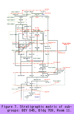 Figure 7 is the stratigraphic matrix of sub-groups from Room 11 drawn in Microsoft
Excel®. It is part of the wider grouped and phased site matrix and is related to the
site archive and phase plans generated and manipulated in G-SYS [13]. I have
highlighted in red where lines on the matrix cross rather than using bridges over crossing
strands. A red crossing line means that the sub-groups in the cross have no relationship
to one another. Room and phase numbers are in green. The sub-groups of each phase are
within corresponding dashed green boxes. Letters in blue denote use, construction,
demolition/re-working or transformation.
Figure 7 is the stratigraphic matrix of sub-groups from Room 11 drawn in Microsoft
Excel®. It is part of the wider grouped and phased site matrix and is related to the
site archive and phase plans generated and manipulated in G-SYS [13]. I have
highlighted in red where lines on the matrix cross rather than using bridges over crossing
strands. A red crossing line means that the sub-groups in the cross have no relationship
to one another. Room and phase numbers are in green. The sub-groups of each phase are
within corresponding dashed green boxes. Letters in blue denote use, construction,
demolition/re-working or transformation.
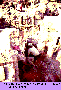 The archaeological deposits in Room 11 were some of the best preserved within the
baths of BEY 045. Deep truncation at the north and south ends of the room, as well as in
its centre, gave the excavators a sneak preview of the sequence (Figure 8). The quality of
preservation within the room, its assumed stratigraphic simplicity, and the ability to
predict and quantify the sequence by means of the truncations implied that we were
dealing with a sequence complicated only by the time in which we had to excavate it.
Needless to say, our initial appraisal was incorrect. At an early stage, during site
cleaning, the room appeared to have been relatively short-lived, and episodes of minor
remodelling which had taken place on subsequent occasions could be seen in section.
However, the room had eventually collapsed, possibly during the earthquake which
devastated Beirut in AD 551. This classic case of over-interpretation at first sight
perfectly demonstrates what is common on sites containing both upstanding and buried
remains. The bigger picture seems at first so much clearer than on many British urban
sites for example. The apparent linear simplicity of the sequence and the ease with which
it can be read seem almost to negate the need for the rigour of strict stratigraphic
recording and single-context planning. However, it is sites of this kind that validate,
precisely because of the quality of their preservation, the adage, 'the closer you look at
stratification, the more complex it becomes. Infinitely'. (Adams 1992: 13).
The archaeological deposits in Room 11 were some of the best preserved within the
baths of BEY 045. Deep truncation at the north and south ends of the room, as well as in
its centre, gave the excavators a sneak preview of the sequence (Figure 8). The quality of
preservation within the room, its assumed stratigraphic simplicity, and the ability to
predict and quantify the sequence by means of the truncations implied that we were
dealing with a sequence complicated only by the time in which we had to excavate it.
Needless to say, our initial appraisal was incorrect. At an early stage, during site
cleaning, the room appeared to have been relatively short-lived, and episodes of minor
remodelling which had taken place on subsequent occasions could be seen in section.
However, the room had eventually collapsed, possibly during the earthquake which
devastated Beirut in AD 551. This classic case of over-interpretation at first sight
perfectly demonstrates what is common on sites containing both upstanding and buried
remains. The bigger picture seems at first so much clearer than on many British urban
sites for example. The apparent linear simplicity of the sequence and the ease with which
it can be read seem almost to negate the need for the rigour of strict stratigraphic
recording and single-context planning. However, it is sites of this kind that validate,
precisely because of the quality of their preservation, the adage, 'the closer you look at
stratification, the more complex it becomes. Infinitely'. (Adams 1992: 13).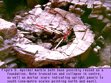 The episode of re-building demonstrated by {112} was based on even earlier structural
failure or room redefinition witnessed in Phase 8, which itself seems to have been a
period of determined consolidation and re-building. A marble bath foundation was
established or re-established (Figure 9), with an apsidal southern end, over an episode of
major -- and one may conclude desperate -- consolidation {110}. Some degree of
collapse {157} occurred during the bath's use, and was sealed by flue-firing deposits
{156}. These deposits indicate the longevity of this phase of use. Alternatively, one may
infer that the bath's superstructure had been lifted and replaced, though this has no basis
in the archaeological record other than its interpretative plausibility. This phase (Phase 8)
dates to the early Umayyad period, and represents a substantial refurbishment of parts of
the bath in a manner reminiscent of the late Roman alterations after the fall of Beirut to
the Muslim armies.
The episode of re-building demonstrated by {112} was based on even earlier structural
failure or room redefinition witnessed in Phase 8, which itself seems to have been a
period of determined consolidation and re-building. A marble bath foundation was
established or re-established (Figure 9), with an apsidal southern end, over an episode of
major -- and one may conclude desperate -- consolidation {110}. Some degree of
collapse {157} occurred during the bath's use, and was sealed by flue-firing deposits
{156}. These deposits indicate the longevity of this phase of use. Alternatively, one may
infer that the bath's superstructure had been lifted and replaced, though this has no basis
in the archaeological record other than its interpretative plausibility. This phase (Phase 8)
dates to the early Umayyad period, and represents a substantial refurbishment of parts of
the bath in a manner reminiscent of the late Roman alterations after the fall of Beirut to
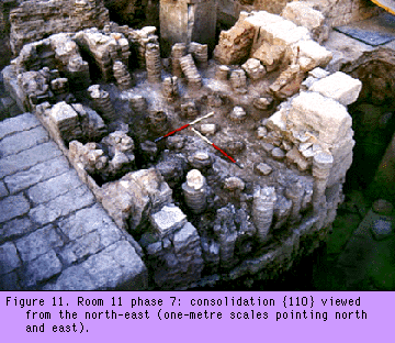
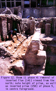
the Muslim armies. Consolidation {110} (Figure 10) seems to have been a response to massive room failure
denoted by Phase 6. It is likely that to achieve this consolidation an earlier floor was
removed in its entirety, due to its ruination and collapse (inferred from the character of
the Phase 6 deposits) and a thick deposit of concrete/mortar (Figure 11) poured between
the pilae of the hypocaust. The space between the base of the hypocaust and the
underside of the suspensurae was 1.25 metres at its highest. This is an unusual height (Figure
12), given the usual height of 0.4 - 0.75 metres recommended by Vitruvius (V; X; 2. Hicky
Morgan 1960), and corroborated by Adam (1989: 266-267, Fig. 624), who suggests that
it was a standard for this type of construction in most of the Roman world.
Consolidation {110} (Figure 10) seems to have been a response to massive room failure
denoted by Phase 6. It is likely that to achieve this consolidation an earlier floor was
removed in its entirety, due to its ruination and collapse (inferred from the character of
the Phase 6 deposits) and a thick deposit of concrete/mortar (Figure 11) poured between
the pilae of the hypocaust. The space between the base of the hypocaust and the
underside of the suspensurae was 1.25 metres at its highest. This is an unusual height (Figure
12), given the usual height of 0.4 - 0.75 metres recommended by Vitruvius (V; X; 2. Hicky
Morgan 1960), and corroborated by Adam (1989: 266-267, Fig. 624), who suggests that
it was a standard for this type of construction in most of the Roman world.
 Although technically there was enough room for a child or small adult to crawl below the
floor of Room 11, it is highly unlikely that {110} was deposited by a gang of small
builders while the suspensurae above remained in place. The fact that sub-group {110}
contained layers of tamping and construction trample between mixes of concrete must
indicate the removal of the floor above to lay it. Logically, the purpose of this
consolidation was to buttress failing pilae stacks and stop the downward movement of
the floor they supported. Evidence also demonstrated that broken stacks {650, 651} had
been replaced upright within this mortar, not bedded on to the hypocaust base. Earlier
pilae collapse was also incorporated into this consolidation. Strata were thus reused
within the context of the post-depositional transformation of the collapse and in doing so
altered its contextual status from 'collapse' to that of a 'coarse component' within
another context. These pilae were not in situ in terms of their original structural
association, though that association could be inferred from direct physical contact with
the remains of their former selves, or in terms of their initial transformation. They were in
situ, however, in terms of their contextual association with the material into which they
had been incorporated.
Although technically there was enough room for a child or small adult to crawl below the
floor of Room 11, it is highly unlikely that {110} was deposited by a gang of small
builders while the suspensurae above remained in place. The fact that sub-group {110}
contained layers of tamping and construction trample between mixes of concrete must
indicate the removal of the floor above to lay it. Logically, the purpose of this
consolidation was to buttress failing pilae stacks and stop the downward movement of
the floor they supported. Evidence also demonstrated that broken stacks {650, 651} had
been replaced upright within this mortar, not bedded on to the hypocaust base. Earlier
pilae collapse was also incorporated into this consolidation. Strata were thus reused
within the context of the post-depositional transformation of the collapse and in doing so
altered its contextual status from 'collapse' to that of a 'coarse component' within
another context. These pilae were not in situ in terms of their original structural
association, though that association could be inferred from direct physical contact with
the remains of their former selves, or in terms of their initial transformation. They were in
situ, however, in terms of their contextual association with the material into which they
had been incorporated.

It was clear that the floor superstructure of Room 11 had previously been buttressed and
consolidated before the episode of consolidation evidenced by {110}. This event also
required the removal and re-bedding of the floor. Flue {141} was relined after an episode
of use and was thus renamed {143}. Pilae stacks were also re-built and additional floor
supports {116, 144} were inserted to provide added strength (Figure 13).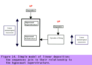 In Figures 14, 15, and 16, I have tried to demonstrate the differing levels of depositional
complexity that may have operated in a situation like that in Room 11. The least complex of the
three models (Figure 14) demonstrates a straightforward sequence of construction,
re-building, and use in simple superposition. This simple model is often inadequate to
explain the site as excavated.
In Figures 14, 15, and 16, I have tried to demonstrate the differing levels of depositional
complexity that may have operated in a situation like that in Room 11. The least complex of the
three models (Figure 14) demonstrates a straightforward sequence of construction,
re-building, and use in simple superposition. This simple model is often inadequate to
explain the site as excavated.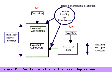

We excavated a burial which had totally re-cut and removed an earlier
primary burial; disarticulated elements from the original skeleton were
redeposited with the second skeleton in the re-cut burial pit. The partially
articulated remains of the original skeleton were also redeposited on top of
the second skeleton. We wanted to show this sequence of activity on the
matrix, and we therefore thought it was necessary to create 'ghost'
contexts representing the original burial pit, though little trace of this
survived.


Copyright © assemblage 1998