
Burdale: an Anglian settlement in the Yorkshire Wolds
Julian D Richards, Steve Roskams, 2013. https://doi.org/10.5284/1021540. How to cite using this DOI
Data copyright © Prof Julian D Richards unless otherwise stated
This work is licensed under a Creative Commons Attribution 4.0 International License.

Primary contact
Prof
Julian D
Richards
Department of Archaeology
University of York
King's Manor
Exhibition Square
York
YO1 7EP
England
Tel: 01904 433901
Fax: 01904 433902
Resource identifiers
- ADS Collection: 1596
- DOI:https://doi.org/10.5284/1021540
- How to cite using this DOI
Introduction
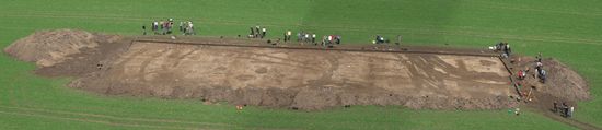
Panoramic view of excavations in 2006, by Ben Gourley
The Anglian settlement at Burdale (SE 875623) is situated in the main Thixendale-Fimber valley, 2km south-east of Wharram Percy (https://doi.org/10.5284/1000415). The valley has been subject to metal-detecting over a number of years and a number of finds, including Romano-British objects, four Anglian strap ends and an 8th-9th century disc brooch were deposited in the Yorkshire Museum in 2000 (YORYM: E2214). However, most of the metal detecting has been illegal 'night-hawking', focussed on the eastern end of the valley away from Burdale House Farm. It is alleged (Mark Ainsley pers comm. 20 March 2007) that this has produced material from the 1st century AD to the 8th century AD, including large numbers of Anglo-Saxon silver sceatta, a dispersed styca hoard, and Anglo-Saxon gold coins.
The site was selected for further investigation as part of a University of York research project to investigate Anglo-Saxon and Anglo-Scandinavian settlement on the Yorkshire Wolds. It was also included within the remit of the VASLE (Viking and Anglo-Saxon Landscape and Economy) project (https://doi.org/10.5284/1000044). The objectives of the fieldwork were:
- To establish the depth, extent and survival of archaeological deposits in the valley bottom
- To explore the nature of sedimentation in the dry valley
- To identify the extent of the 8th and 9th century activity and to determine the development of the site
- To establish the relationship of the metalwork finds and the features
- To collect environmental and artefactual samples
- To determine the nature of the 8th-9th century activity on the site
- To help protect the site from further illegal metal-detecting
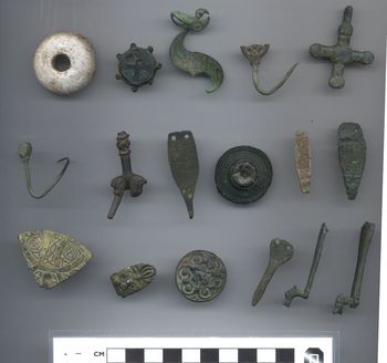
Selection of finds deposited by Neil Campling
in the Yorkshire Museum (YORYM: E2214)
Preliminary reconnaissance, including field-walking and magnetometry confirmed settlement activity. The crop marks indicated two concentrations of Anglo-Saxon activity: the first, at the western end comprised enclosure ditches, trackways and various cut features, possibly buildings. Intercutting features demonstrated that several phases of activity were represented. Magnetometry yielded significant magnetic anomalies in this area, suggestive of intense burning. There appeared to be a gap in activity to the south-east, with no crop marks at the junction of Whaydale and the main valley. Further east, however, there was a second concentration of activity with traces of several 'Butterwick-type' enclosures, as well as more rectangular enclosures, most clearly visible at the eastern end â Hayfield's Burdale/Fimber boundary farmstead. Field-walking and metal-detecting confirmed this twin focus of activity, although there was a background scatter of artefacts across the valley. The soils within the western concentration were much darker and contained more loam. Test pit excavations suggested that deposits were thicker here, and quantities of medieval pottery were recovered, possibly relating to middens associated within the vill underlying Burdale House Farm. Two seasons of excavation were undertaken, on the eastern and western groups of enclosures, in 2006 and 2007 respectively, as student training exercises for the University of York.
A summary report of the Burdale project has been published as Richards and Roskams (2012) "Investigations of Anglo-Saxon occupation in Burdale: an interim note" in S. Wrathmell (ed.) Wharram: A Study of Settlement on the Yorkshire Wolds XIII: A History of Wharram Percy and its Neighbours. York Univ Archaeol Publ 15, 113-8. Post-excavation, led by Julian Richards, was delayed due to other commitments but resumed in 2012 and was completed in 2013. The physical archive has been deposited with Malton Museum.
An associated data paper, including more details of the findings has been published in Internet Archaeology: Richards, J., & Roskams, S. (2013). Burdale: An Anglian Settlement in the Yorkshire Wolds (Data Paper). Internet Archaeology, (35). Council for British Archaeology. https://doi.org/10.11141/ia.35.8.
