Overview
We report here on a project aimed at securing, consolidating and enhancing the archives compiled during excavations of Nottingham’s Anglo-Scandinavian Borough by staff of the Nottingham City Field Archaeology Section (Young, C S B 1982 and 1986; Young, G A B 1987). This early focus of settlement extended across the high sandstone ridge that is crowned today by St Mary’s Church, and by the ninth century appears to have been defended by a substantial rampart with outer ditch. This project has provided a valuable foundation for future study of the material remains recovered from these sites, and has highlighted the importance of the archive as a resource for research into the origins and growth of Nottingham from the Early Medieval period.
Excavations were conducted between 1969 and 1980 at five sites inside the Anglo-Scandinavian Borough, at Drury Hill, Woolpack Lane, Fisher Gate, Boots Garage and Halifax Place, and at a site on Goose Gate, lying just beyond the pre-Conquest rampart. The excavation trenches were carefully positioned with the aims of locating and characterising the Borough defences and of investigating areas of the interior with potential for the preservation of significant archaeological remains. The archive derived from these excavations represents a major untapped resource for study of the early development of Nottingham, which since its rise to prominence as one of the Five Boroughs of the Danelaw has played a key role in the history of England.
A plan of Nottingham, showing the location of the six excavated sites and their relationship to the Anglo-Scandinavian and later medieval defences of Nottingham is included in the Project Summary and should be referred to when reading the summary below.
Excavations commenced in 1969 at Drury Hill, on a site shown to straddle the south-western defences of the Anglo-Scandinavian Borough. Fieldwork uncovered traces of a rampart and a massive flanking ditch running along the eastern edge of Drury Hill. The ditch was believed to have cut what was interpreted as a sunken-floored building attributed to the period c.850–1000, providing possible evidence of settlement along the cliff edge prior to construction of the defences; it preserved evidence of a major recut dated to the tenth century, but the date of its construction, whether before or during the Danish occupation, remains unclear. The rampart was levelled in the immediate post-Conquest period, and the ditch was filled and built over. Excavations revealed ditch deposits beneath a late eleventh century square, timber-built, two-room cottage, which in the early twelfth century was replaced by a timber aisled hall. Property boundaries were re-aligned along new frontages around 1150, following destruction by fire of the aisled hall; in the 1690s, a courtyard arrangement was established that persisted with some modifications until wholesale demolition in the late 1960s prior to construction of the Broadmarsh Shopping Centre.
Excavations in 1970 at Woolpack Lane uncovered on the northern side of the Borough another length of the defensive ditch, together with probable traces of the levelled rampart, running from west to east along the northern edge of Woolpack Lane. As at Drury Hill, the ditch preserved evidence of a major recut. The fully silted ditch was cut in the first half of the twelfth century by another substantial ditch, separated from an internal bank by a wide berm, which was interpreted as part of the medieval defences that had enclosed both the Anglo-Scandinavian and Norman Boroughs. The defences represented by this twelfth century feature may have continued north-west along the eastern edge of, or beneath, Cranbrook Street, and were found to cut the pre-Conquest defences and follow their course to the south-east.
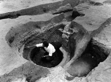
Intermittent excavations between 1971 and 1978 to the north of Fisher Gate revealed a wide and fairly shallow west–east ditch that it was suggested might mark the southern boundary of an early Anglian settlement extending eastwards of the Anglo-Scandinavian Borough, but the date and purpose of this feature remain uncertain. The area south of this ditch seems to have been unoccupied until the construction in the late ninth or tenth century of a timber building interpreted by Charles Young as a bow-sided hall reminiscent of post-built structures recorded at Halifax Place (below). Yet later developments include the construction around 1100 of a cobbled road joining Bellar Gate and Carter Gate. The road frontages were flanked by barn-like timber houses fronting land plots preserving pits, ovens and kilns. One of the more important discoveries was a rock-cut corn-drying kiln, dated from between c.1100 and 1350, which had burnt down while in use. The kiln pit was connected to a stoke-hole approached by rock-cut steps, and was edged by stake-holes preserving the charred remains of a wattlework frame of hazel that had survived partially in situ. This frame had been lined internally with clay, and was separated from the pit wall by a thin layer of sand packing. Grain had been dried on the floor of an above-ground compartment, which was reconstructed as a domed wattlework construction sealed externally by clay. The kiln yielded an abundance of carbonised emmer wheat, including complete ears on stalks, and remains unique in Nottingham in terms of the richness of its charred plant remains and the level of structural preservation. Clearance around 1300 retained the cobbled road joining Bellar Gate and Carter Gate, but discovery of a range of new buildings suggests amalgamation into one property; these new buildings included a timber building with service wing, warehouses or workshops and a courtyard. The area was derelict from c.1350 until the fifteenth century, which saw the construction of a substantial boundary wall that was later cut by a probable Civil War ditch. In the nineteenth century, as Nottingham developed its industrial base, the area became a focus for tightly packed workers’ housing.
Excavations in 1972 at Boots Garage, between Woolpack Lane and Barker Gate, revealed a wide and fairly shallow east–west ditch, which was interpreted as possibly the northern boundary of the early Anglian settlement postulated at Fisher Gate, but as on that site doubts remain regarding the purpose and date of this feature. The Barker Gate frontage was greatly disturbed by Post-Medieval and later building foundations and cellars, but traces survived of occupation dating back to around 900. Along Woolpack Lane, a slight wattle and daub structure of ninth or tenth century date was recorded. This was replaced by successive timber buildings, followed by clearance in the thirteenth century for a malt kiln and associated cellar. These structures were overlain by buildings of the twelfth and thirteenth centuries, including one with a cellar dated to c.1290 that was identified in deeds. Evidence of industrial activity in the period spanning the Norman Conquest was found in the form of a corn-drying kiln and a possible smelting hearth, while later activity was indicated by a large bowl-shaped kiln or oven dating to the thirteenth century. These backlands appear to have been abandoned by c.1350.
From 1978 to 1980, excavations in the heart of the Anglo-Scandinavian Borough at Halifax Place revealed evidence of early activity in the form of a linear boundary ditch dated to between 650 and 850 and a remarkable group of large, rectilinear timber buildings of at least three phases predating 1000. Clearance of these structures in the eleventh century was followed by the construction of new buildings and of a pottery kiln dating to c.1000. Other evidence for industry attributable to the period from c.1030–1070 was provided by several timber-lined pits that may have been used for tanning. The site was reorganised around 1100, with properties along at least two frontages and intense activity until c.1350, including eight corn-drying kilns, pits and an oven or kiln. A third frontage was occupied by buildings in the thirteenth century, preceding a phase of dereliction, rebuilding in the seventeenth and eighteenth centuries and, in the nineteenth century, industrialisation associated with lace manufacture. Nine caves were also encountered on the site, including at least three that may date from the High Medieval period.
Excavations at Goose Gate in 1976 and 1977, immediately outside the northern defences of the Anglo-Scandinavian Borough, revealed buildings spanning the period from c.1100 to c.1350. Pits, ovens and corn-driers were recorded behind the buildings, together with one, or possibly two, pottery kilns producing Nottingham Splashed Ware. These were replaced by more pits and by two cellar buildings, probably used as warehouses or workshops. One of these buildings appears to have been abandoned by c.1350, but the other cellar was used until the sixteenth century. A fifteenth century malt kiln, a cave system in use during the High Medieval and Post-Medieval periods, and a seventeenth century latrine in a timber shed were also recorded. The site seems to have been abandoned by the end of the seventeenth century, and is shown on a map published in 1744 by Badder and Peat as the location of an orchard. The area was redeveloped with the construction of a brewery in 1792 and further developed during the industrialisation of the Lace Market in the nineteenth century.
References
- Knight, D, Lomax, S and Young, G 2012 ‘The origins of Nottingham: archaeological investigations in the medieval town from 1969 to 1980’. Transactions of the Thoroton Society of Nottinghamshire 116, 45–52
- Mastoris, S and Groves, S (eds) 1997 Sherwood Forest in 1609: a Crown Survey by Richard Bankes. Thoroton Society of Nottinghamshire Record Series 40
- Young, C S B 1982 Discovering Rescue Archaeology in Nottingham. Nottingham: Nottingham City Council Museums
- Young, C S B 1986 ‘Archaeology in Nottingham: the pre- Conquest Borough’ in Mastoris, S N (ed) History in the Making: Recent Historical Research in Nottingham and Nottinghamshire 1985. Nottingham: City of Nottingham Museums, 1–4
- Young, G A B 1987 ‘Archaeology in Nottingham: the Halifax Place excavation’ in Mastoris, S N (ed) History in the Making: Recent Historical Research in Nottingham and Nottinghamshire 1986. Nottingham: City of Nottingham Museums, 1–6