Introduction

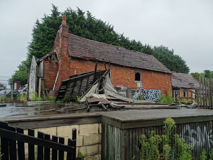
This collection comprises of images, spreadsheets, laser scanning, report, CAD, GIS and photogrammetry from a building survey at Capitol Joinery Timber Yard, Coleshill, Warwickshire, 2019-2023.
Project Summary
The Project Plan for Capitol Joinery Timber Yard (Doc. No: 1EW04-LMJ-DJV-EV-PLN-NS04_NL10-029007) defined the scope, rationale, aims and objectives for the historic building recording. The Project Plan provided a summary of the origins and historic development of the Site through an external assessment and through an assessment of available historic cartographic sources, as gathered during the preparation of the HS2 Phase One Environmental Statement. It also defined the methodology for the appropriate level of historic building recording.
The LS-WSI for the historic building recording (Doc. No: 1EW04-LMJ-EV-MST-NS04_NL10-029007) was prepared in response to the Project Plan, setting out how the building recording works would be delivered. It had been prepared in accordance with the standards and guidance provided by the GWSI: HERDS, the Technical Standards for Specification for Historic Environment Project Plans (HS2-HS2-EV-STD-000-000036) and Location Specific Written Schemes of Investigation (Doc. No: HS2‐HS2‐EV-STR-000-000015), the Specification for Historic Environment Investigations (Document No. HS2‐HS2‐EV‐STD‐000‐000035) and the relevant CIfA Standards including the Standard and guidance for the archaeological investigation and recording of standing buildings or structures (CIfA, 2020).
The aims and objectives of the historic building recording are set out in the Project Plan and the Location Specific Written Scheme of Investigation. The historic building recording was to be undertaken to a Level 3 survey, as agreed within the Project Plan and defined in Historic England’s 2016 Understanding Historic Buildings: A Guide to Good Recording Practice. The creation of the record was required ahead of the demolition of the buildings at the Site to ground level prior to commencement of Coleshill No.3 Embankment and Coleshill East and West Viaducts as an element of the enabling works programme for the HS2 project in the Coleshill area. A record of the Site within its setting was also made.
The objective of the historic building recording as detailed within the Project Plan was to investigate and record each of the buildings at the Site, with particular consideration to be given to:
- The use and character of each building, and its component parts, and evidence of its function as part of a working farm, sawmill or other.
- Identifying and explaining any elements of particular architectural or historic significance within the Site.
- Identifying the extent of survival of original buildings depicted on Snape’s map of 1783 and the Parish Plan of 1843-44 and assisting in building an understanding of the Site’s development.
- Explaining the relationship between each of the buildings and whether any ‘process flow’ existed.
- Explaining what prompted the construction of the Site, its original use and changes to its layout that occurred during the centuries.
- The role of the Site in the context of the Coleshill Hall Estate, before and after the demolition of the manor, and its role within the local area and in connection with the nearby town of Coleshill.
- Recognising changes in the buildings’ functions over time and whether these reflected changes in the social status or lifestyle of the Site’s occupiers, in connection with social changes in the local area.
3.1.5 Setting recording aimed at elucidating the relationship between the Site and the extended Coleshill Hall Estate, from the post-medieval period to the 20th century, with particular consideration to be given to:
- Clarifying the use of the land in the demesne of the Estate and its connection with the buildings on the Site.
- Understanding patterns of circulation in and out of the Site when the buildings served the Hall as ancillary structures and during the following centuries.
- Understanding the relationship between the buildings on the Site and the Victorian Coleshill Hall, built to the north of the River Cole in 1873.
3.1.6 Further aims of the building and setting recording were to:
- Cross-reference the information collected from the physical evidence of the buildings and landscape with information from documentary sources, in order to form an architectural and social history of the asset that contributes to an understanding of the local area development.
- Contribute to the understanding of small-scale industrial activities in the post-medieval period in the local area, whether this applies to the Site.
The scope of works seeks to create knowledge and outputs that contribute to the following GWSI: HERDS Specific Objectives:
- KC39: Develop a detailed understanding of the nature, formation, date, and chronology of the historic landscape at Coleshill including the former Coleshill Deer Park, Coleshill Hall Farm and moated site?
- KC44: How did rural industries fare, and what was their contribution to society over to the period of the urban-centred industrial revolution?
- KC52: Understanding the pattern, form and function of post-medieval rural vernacular architecture: can we identify regional, intra-regional or temporal variations?
Re-Use Value Statement
The location, extent, survival and significance of any heritage assets of archaeological interest on this site have been captured in this dataset. This can inform future research into the archaeology and practices within the site and surrounding landscape, but also for the county as a whole.


