Introduction
This collection comprises image, text and GIS data from The Routes and Roads of the Gough Map project undertaken by Eljas Oksanen (Department of Cultures, University of Helsinki) and Stuart Brookes (UCL Institute of Archaeology) between 2015 to 2024.
The Gough Map of circa 1400, so named after Richard Gough who bequeathed it to the Bodleian Library, Oxford, in 1809, is one of the oldest surviving maps of Great Britain and unparalleled among its predecessors for its geographic detail and scope. This digital resource uses it to generate new data on medieval overland travel and transport in England and Wales.
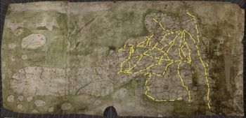
One feature of the map that has excited a great deal of interest among historians of the Middle Ages are the so-called “red lines” that connect together a number of the towns and settlements. Nine-tenths of the circa 190 lines are accompanied by a Roman numeral — accepted as a distance value — and in aggregate these have traditionally been seen as representing a sample of the English and Welsh overland route network. If so, the map is of tremendous value to scholars working with travel, communications and transport in the Middle Ages. But owing to the schematic and incomplete nature of the "network" there has also been debate on whether a more conservative interpretation, one that characterises the red lines as simply indicating distances and a sense of connectedness between settlements, should be preferred.
New Geographic Information Systems (GIS) analysis and methodologies have enabled a complete reassessment of the evidence. The Routes and Roads of the Gough Map of Great Britain: GIS Database maps the red lines and the settlements they connect, and matches them with routeways reconstructed from documentary, archaeological, place-name and other historical cartographic evidence. It can be shown that in almost every instance a red line can be parsed with a historical road or a routeway, and in one case a red line clearly designates a navigated section of the River Witham. Various routes represented on the map match with pathways from the Early Modern to at least the Roman periods, capturing important aspects in the long-term evolution of overland travel connections.
From this data it is clear that the Gough Map depicts a select sample of the travel and communications network existing at the time of its composition. While the map by no means contains a full depiction of the route network that existed in the Middle Ages — or even of all the major overland connections — the historical importance of its red lines lies in their representation of the most extensive single depiction of contemporary travel routes across the kingdom, as chosen by its creator or creators. When combined with data on medieval bridges and navigated inland waterways archived in the Early Medieval Atlas, as well as coastal routes, the combined transport network connects a substantial majority of the major urban and commercial sites in England and Wales. As such these resources form the basis and a key reference for reconstruction and evaluating the scope and character of the medieval travel, transport and communications systems in these countries.
The GIS dataset contained in the geopackage file comprises spatial data allowing for the plotting of features depicted on the Gough Map (points relating to the settlement icons connected to a red line, and schematic vector line representation of the red lines) as well as ground-truthed vector line representations of the historical routeways or roads that match the red lines.