Introduction
This collection contains a survey report alongside geophysics (magnetometry), GIS, and CAD data from a geophysical survey at Land at North Leigh, West Oxfordshire. Work was undertaken by SUMO Geophysics in November 2023.
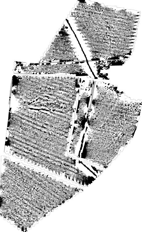
The magnetometer survey investigated 11 hectares of land at North Leigh, recording magnetic responses that have been interpreted as being of archaeological interest. A segmented ditch-like anomaly and a zone of increased response have been detected which appear to correspond with Grim’s Ditch. Another possibly linked weaker linear anomaly has also been recorded. Uncertain anomalies are also visible in the survey which are likely to be products of agricultural and natural processes. Ridge and furrow cultivation has been detected in Areas 1, 3, 4 and 5 plus the route of a service pipe has also been marked.
Methodology
A temporary grid system was established over the site and marked out using canes. The location of the grid was set out using an RTK GPS system theoretically accurate to some 0.01m and referenced to OS co-ordinates. Data was collected using a cart carrying four paired Bartington magnetic sensors. Four sensors mounted 1m horizontally apart and very accurately aligned to nullify the effects of the earth's magnetic field. Readings relate to the difference in localised magnetic anomalies compared with the general magnetic background. Each data point is geographically referenced using an on-board Trimble RTK survey grade GPS system. Readings were taken at 0.125m centres along traverses 1.0m apart. Readings relate to the difference in localised magnetic anomalies compared with the general magnetic background. The magnetometer survey has recorded magnetic responses that have been interpreted as being of archaeological interest. A segmented ditch-like anomaly and a zone of increased response have been detected in the survey which appear to correspond with Grim's Ditch, a scheduled monument that is located in Area 3 (1013236). A second weaker line of pit-like anomalies is also visible in Area 3 and thought to be of possible interest. Anomalies of uncertain origin have been detected throughout the survey which are likely to be due to a combination of agricultural and natural processes. Ridge and furrow cultivation has been detected in Areas 1, 3, 4 and 5 plus the route of a water pipeline has also been marked.