Whitton Burn 2a
ERA ID: 1233Showing:
| Panel name | Whitton Burn 2a |
|---|---|
| ERA ID | 1233 |
| Beckensall ID | 631 |
| Panel type | Art in the landscape: boulder |
| Nature of access | Private owner |
| Current location | At original location |
| County | Northumberland |
| District | Alnwick |
| Parish | Whitton and Tosson |
| NGR | NU 06561 00146 |
| Latitude | 55.295344 |
| Longitude | -1.896664 |
| Bibliography |
|
NADRAP Notes
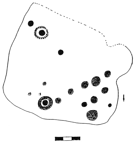
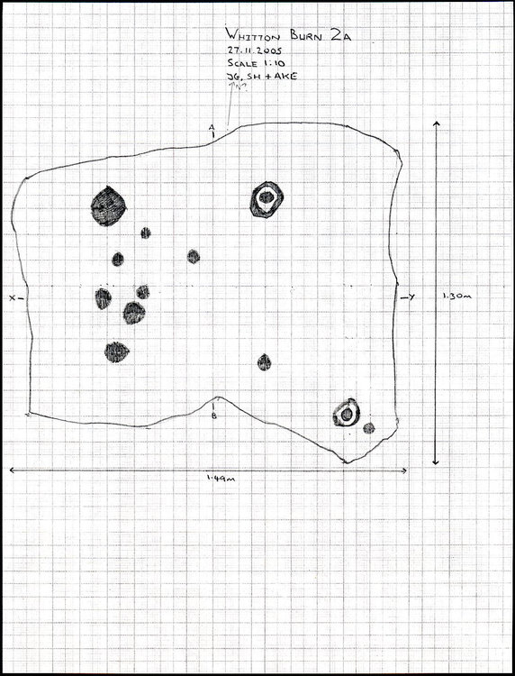
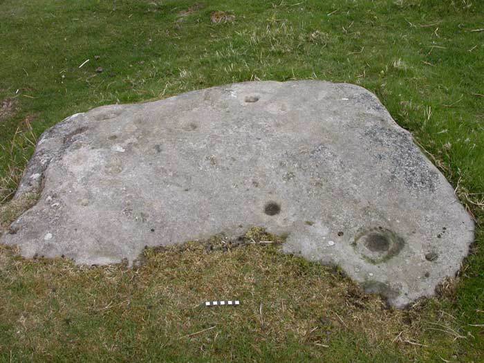
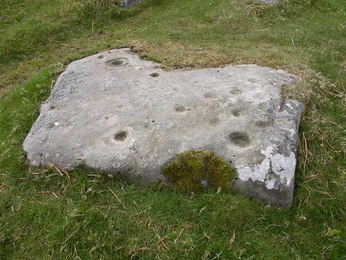
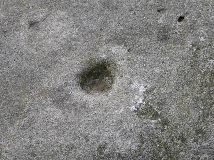
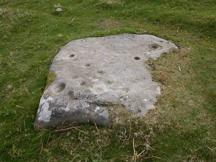
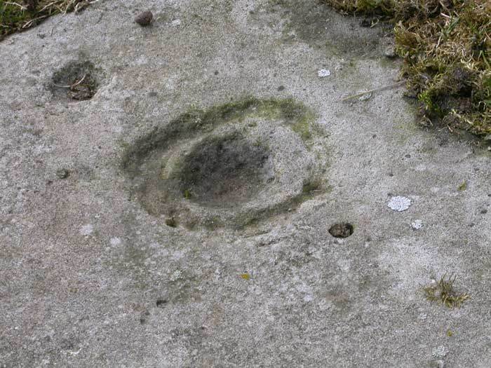
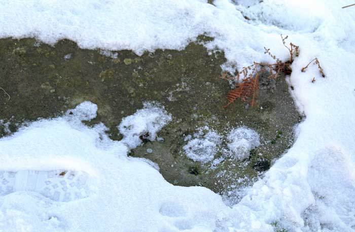
This is an almost square panel of stone lying flush with the ground. It is unknown for certain if this is a boulder or quarried stone as only the uppermost (decorated) face is visible and vegetation is tight around the edge. There is evidence of such quarrying of outcrop in the immediate area of this panel. However, this stone is of some archaeological interest; the panel bears two types of motifs. These are simple cup marks and cup and (single) ring marks. The cup and ring marks are also different to each other; one appears pecked and angular. The motifs are scattered across the surface. Whether or not this is a boulder quarried from the adjacent outcrop is uncertain. However, the panel is situated on or near the top of a broad ridge. This position gives good views in most directions - including much of the North Lordenshaw group 6 panels, on the opposite side of the Whitton stream. The other rock art panels called Whitton Burn are lower down to the north and west, nearer the valley sides, and are invisible from this panel. The two cups with rings are noted for their difference. The first appears complete and well formed The second looks more recent, more angular and rough inside, perhaps made by pecking (as opposed to smoothing). The other cups are uniform in size and well rounded; though one is elongated of 0.12m length, the others are about 0.10m diameter.
Beckensall Archive Notes
The Whitton Burn 2 area has been quarried, and the burial mounds reported by D.Dixon 'on a little plateau near this rock' have disappeared. Only one rock was described by Messrs. Parker Brewis and D.D.Dixon in The Proceedings of the Society of Antiquaries of Newcastle, 3rd.Series, Vol. VII, p.41,
The exact nature of the motifs identified may differ with separate recording projects. The Beckensall Archive data is based on drawings, some made a number of years ago, whereas the NADRAP recordings reflect motifs currently visible in the field. The effects of weathering, of human and animal impacts and especially the presence of biological growths such as lichen, moss or turf may have resulted in motifs becoming obscured or, in some cases, revealed. Changes in lighting may also affect what is visible. Photogrammetry models now provide the most accurate record of the panel, but some details may have been lost over time; historical drawings therefore provide a valuable snapshot. Recent research also suggests that prehistoric people may have incorporated natural features into their carvings, sometimes enhancing them. This means that it is difficult to determine whether some features are natural or human made.
NADRAP Motif Details
| Elements |

|
|---|
Beckensall Archive Motif Details
| Elements |


|
|---|
Notes
The panel has two ringed cups and 12 others, with three small, faint ones.
Measurements
| Orientation from | West |
|---|---|
| Orientation to | East |
| Orientation of slope (top) | South |
| Orientation of slope (bottom) | North |
| Slope (°) | 6-10 |
| Length (m) | 1.49 |
| Width (m) | 1.3 |
| Height (m) | 0.25 |
Geology
| Panel geology | Sedimentary |
|---|---|
| Surface topography | Sloping |
| Fissures/cracks present | No |
| Natural hollows | No |
| Visible bedding planes | Yes |
| Visible weathering channels | No |
| Grain size (μ) | Medium 250-500 |
| Surface compactness | Friable |
| Visible components | Quartz |
Location
| NGR | NU 06561 00146 |
|---|---|
| Latitude | 55.295344 |
| Longitude | -1.896664 |
| OSGB method | GPS |
| County | Northumberland |
| District | Alnwick |
| Parish | Whitton and Tosson |
Landscape context
| Altitude (m) | 154 |
|---|---|
| Altitude method | GPS |
| Terrain | Sloping |
| Position | Middle (e.g. hillside) |
| Proximity to watercourse (m) | 100 |
| Underlying geology | Sedimentary |
| Land use | Impoved pasture |
Archaeological context
| Panel type | Art in the landscape: boulder |
|---|---|
| Current location | At original location |
| Prehistoric features | Rock art |
NADRAP Notes
There is another rock art panel close by this panel (Whitton Burn 2b). There is also exposed bedrock through nearby quarrying, and running roughly parallel to this a field wall of earth and stone topped by a wire fence.
Management
The condition of rock art, and the nature of threats to its survival, can change rapidly with alterations to either the local environment, the use of the land, or the accessibility of the panel. NADRAP assessments were made during the period 2005 - 2008. See the help page for more information on assessments and management.
Assessment
0 = no impact/risk; 3 = significant impact/riskCondition
| Chemical and physical erosion | 1 |
|---|---|
| Biological coverage | 2 |
| Animal/human impacts | 3 |
| Overall Condition | Moderate |
Risk
| Chemical and physical risk | 3 |
|---|---|
| Biological risk | 2 |
| Animal/human risks | 3 |
| Overall Risk | Severe |
View detailed Assessment Report
Assessment Report
Physical and Chemical
| Condition | Carved Area | Exposed Area |
|---|---|---|
| Differential | None | < 1/3 |
| Planar | None | None |
| Cratering/pitting | None | None |
| Burnt areas | None | None |
| Threat | Severity |
|---|---|
| Water flow | None |
| Water pool | Moderate |
| Prevailing weather | Severe |
Biological
| Condition | Carved Area | Exposed Area |
|---|---|---|
| Lichen (crustose) | 1/3 - 2/3 | 1/3 - 2/3 |
| Lichen (foliose) | < 1/3 | < 1/3 |
| Moss | None | < 1/3 |
| Algae | None | None |
| Grass/turf | None | None |
| Other condition | None | None |
| Detritus | None | None |
| Threat | Severity |
|---|---|
| Lichen (crustose) | None |
| Lichen (foliose) | None |
| Moss | None |
| Algae | None |
| Tree canopy | None |
| Other threat | None |
| Detritus | None |
Animal and Human
| Condition | Carved Area | Exposed Area |
|---|---|---|
| Wear (rubbing/trampling) | 1/3 - 2/3 | 1/3 - 2/3 |
| Droppings (game/stock) | > 2/3 | > 2/3 |
| Quarrying | None | None |
| Chips or scratches | None | None |
| Graffiti (painted) | None | None |
| Graffiti (carved) | None | None |
| Plough/flail marks | None | None |
| Threat | Severity |
|---|---|
| Stock animals | Severe |
| Game animals | None |
| People | None |
| Land management | None |
| Other Human/Animal | None |
Risk factors
| Land use | Impoved pasture |
|---|
Management factors
| Distance to road (m) | 150 |
|---|---|
| Distance to bridleway (m) | 250 |
| Distance to footpath (m) | 250 |
| Distance to habitation (m) | 700 |
| Distance to parking (m) | 150 |
| Open access land | No |
| Subject to HLS stewardship scheme | No |
| Interpretation on site | No |
See the help page for descriptions of specific media types and guidance on accessing IIIF resources for images.
Open a IIIF workspace containing all IIIF-compatible images belonging to this panel.
Media From the NADRAP Archive
Conventional Photograph
Open in IIIF Viewer.jpg)
.jpg)
.jpg)
.jpg)
.jpg)
.jpg)
.jpg)
.jpg)
Panoramic Photograph
Open in IIIF Viewer.jpg)
Photogrammetry Image
Open in IIIF Viewer(t3).jpg)
(t3).jpg)
(t3).jpg)
(t3).jpg)
Photogrammetry Form
Open in IIIF Viewer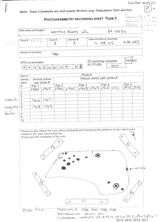
General Sketch
Open in IIIF Viewer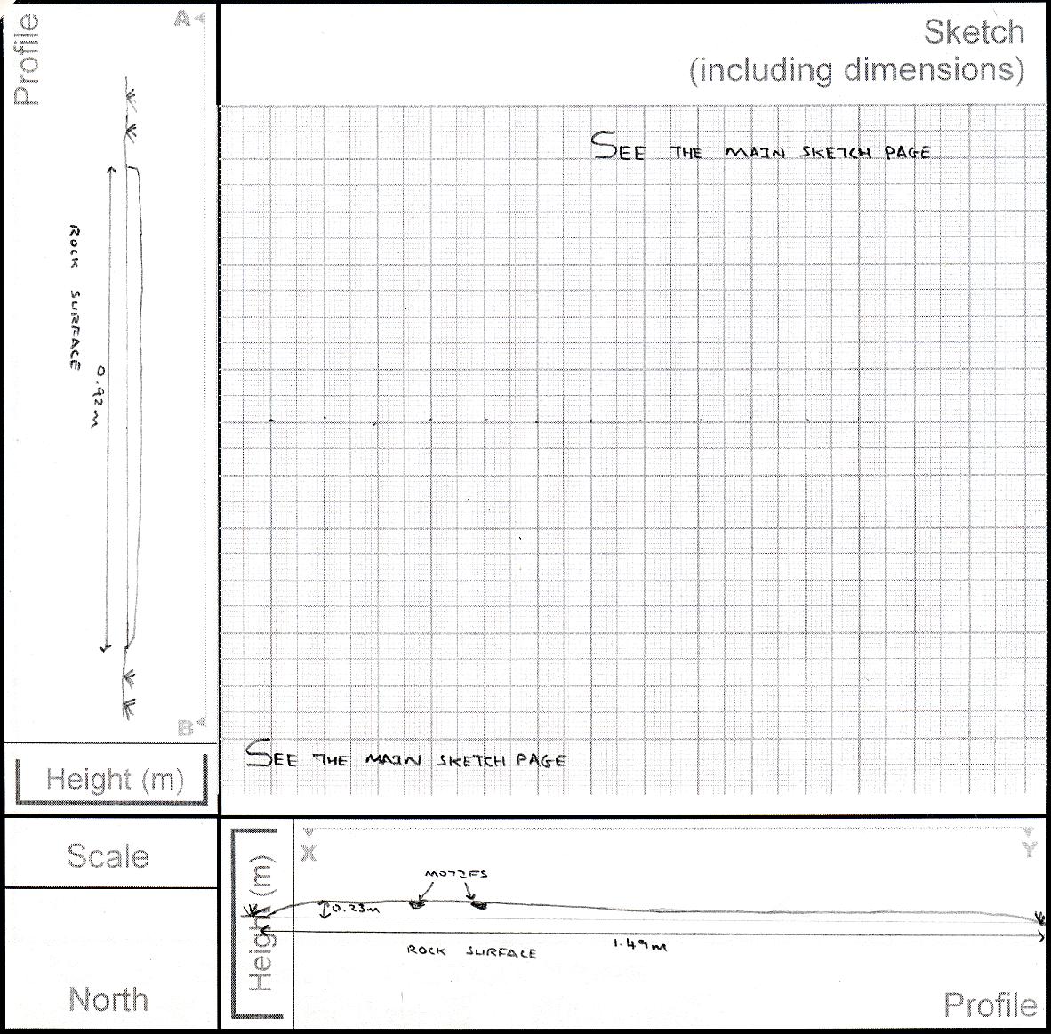
VRML Model
QTVR Movie
Media From the Beckensall Archive
Beckensall Photograph
Open in IIIF Viewer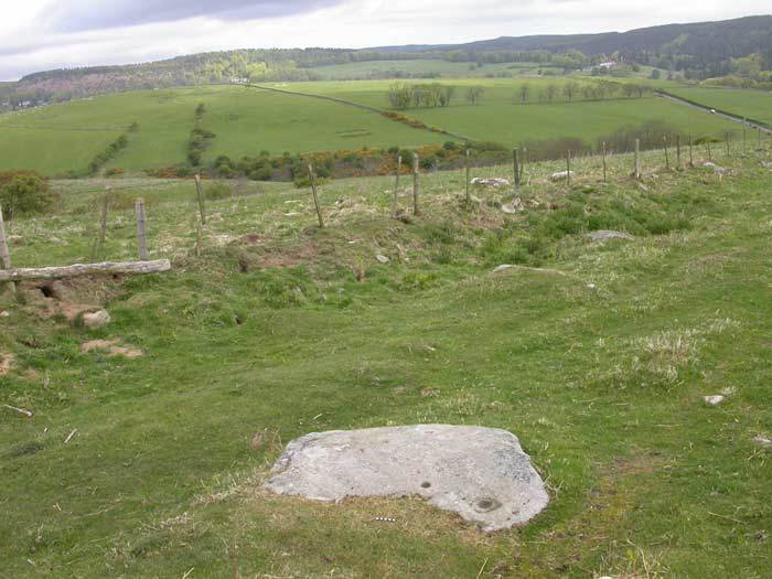
Beckensall Negative
Open in IIIF Viewer
Beckensall Drawing
Open in IIIF Viewer